Sold (333)
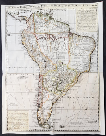
1719 Henri Chatelain Large Original Antique Map of South America
- Title : Carte De La Terre Ferme, Du Perou, Du Bresil, et du Pays des Amazones..
- Ref #: 50619
- Size: 28 3/4in x 22 1/4in (730mm x 565mm)
- Date : 1719
- Condition: (A+) Fine Condition
Description: This large, scarce, highly detailed & beautifully hand coloured original antique map of South America was published by Henri Abraham Chatelain in the 1719 edition of Atlas Historique.
Background: This map was engraved with Chatelain's usual eye for detail, with all the known information available at the time of publication. Old known highly detailed coastal information is included along with much speculative detail of the interior and the river systems of the Amazon and River Plate. In the southern part of the are the tracks of the exploration routes of explorers such as Magellan, Charp, Vespuce & many others. Chatelain has also included text boxes top and bottom with detailed remarks on the continent. (Ref: Tooley; M&B)
Atlas Historique: First published in Amsterdam from 1705 to 1720, the various volumes were updated at various times up to 1739 when the fourth edition of vol.I appeared, stated as the "derniere edition, corrigée & augmentee."
The first four volumes seem to have undergone four printings with the later printings being the most desirable as they contain the maximum number of corrections and additions. The remaining three final volumes were first issued between 1719-1720 and revised in 1732.
An ambitious and beautifully-presented work, the Atlas Historique was intended for the general public, fascinated in the early eighteenth century by the recently conquered colonies and the new discoveries. Distant countries, such as the Americas, Africa, the Middle East, Mongolia, China, Japan, Indonesia, etc., take an important place in this work.
In addition to the maps, many of which are based on Guillaume De L'Isle, the plates are after the best travel accounts of the period, such as those of Dapper, Chardin, de Bruyn, Le Hay and other.
Other sections deal with the history of the European countries, and covers a wide range of subjects including genealogy, history, cosmography, topography, heraldry and chronology, costume of the world, all illustrated with numerous engraved maps, plates of local inhabitants and heraldic charts of the lineages of the ruling families of the time. The maps, prints and tables required to make up a complete set are listed in detail in each volume.
The accompanying text is in French and often is printed in two columns on the page with maps and other illustrations interspersed. Each map and table is numbered consecutively within its volume and all maps bear the privileges of the States of Holland and West-Friesland.
The encyclopaedic nature of the work as a whole is reflected in this six frontispiece. The pages are the work of the celebrated Mr. Romeijn de Hooghe. and are engraved by J.Goeree, T.Schynyoet and P.Sluyter.
New scholarship has suggested the compiler of the atlas, who is identified on the title as "Mr. C***" not to be Henri Abraham Chatelain, but Zacharie Chatelain. (See Van Waning's article in the Journal of the International Map Collectors' Society for persuasive evidence of the latter's authorship.)
Condition Report:
Paper thickness and quality: - Heavy and stable
Paper colour: - Off white
Age of map colour: - Early
Colours used: - Yellow, pink, green
General colour appearance: - Authentic
Paper size: - 28 3/4in x 22 1/4in (730mm x 565mm)
Plate size: - 28in x 21in (710mm x 535mm)
Margins: - Min 1/2in (10mm)
Imperfections:
Margins: - None
Plate area: - Folds as issued
Verso: - None
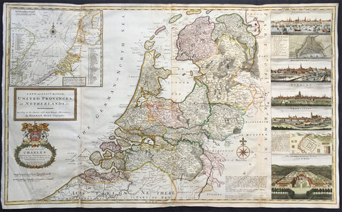
1720 Herman Moll Large Antique Map of The Netherlands - Holland, VII Provinces
- Title : A New and Exact Map of the United Provinces, or Netherlands &c. According to the Newest and Most Exact Observations by Herman Moll Geographer
- Ref #: 35090
- Size: 41in x 25in (1.04m x 635mm)
- Date : 1720
- Condition: (A+) Fine Condition
Description:
This very large beautifully hand coloured original antique map* of The Netherlands by Herman Moll was published in 1720 in the atlas The World Described, or a New and Correct Sett of Maps by John Bowles, Thomas Bowles, Philip Overton & John King of London.
In the 18th century many large-scale maps were published by the likes of John Senex and Herman Moll, this trend continued until the end of private mapping in the early 19th century when it was replaced by Ordnance Survey maps.
Background: An attractive, large scale map of The Netherlands or the United Provinces by the highly regarded cartographer and engraver Herman Moll. on the right-hand side views of Amsterdam, Rotterdam, Middelburg, Utrecht, Groningen, Het Loo Palace and a plan of the ancient Roman Castle at the mouth of the Rhine river Arx Britannica (Huis Britten, Brittenberg). The upper left corner of the map has an inset map of the coasts, sands and banks of the North Sea, the stretch of water that lies between England and The Netherlands. Moll dedicates his map to ‘The Right Hon Charles Lord Viscount of Townsend &c one of his Majesty’s Principal Secretaries of State’
This magnificent map was printed by John Bowles of Cornhill, London and published in Moll’s 1719 New and Complete Atlas, but it may also have been separately issued earlier. Moll came to London probably from Bremen around 1678 and by 1688 he had his own shop in Vanley's Court in London's Blackfriars, between 1691 and 1710 at the corner of Spring Gardens and Charing Cross, when he moved to Beech Street where he remained until his death. In 1701 he published his first work A System of Geography. He was publishing atlases and separately issued maps, and from 1710 was also known as a maker of pocket globes. (Ref: Tooley, Koeman, M&B)
General Description:
Paper thickness and quality: - Heavy and stable
Paper color: - off white
Age of map color: - Original & later
Colors used: - Pink, yellow, green
General color appearance: - Original
Paper size: - 41in x 25in (1.04m x 635mm)
Plate size: - 39 1/4in x 24 1/2in (1.00m x 625mm)
Margins: - Min 1/2in (10mm)
Imperfections:
Margins: - Light creasing
Plate area: - Re-joined folds as issued, small repair in top L&R folds, no loss
Verso: - Re-enforced along folds
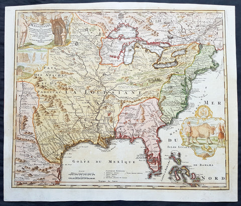
1720 Homann Large Old, Antique Map of North America, Louisiana, Mississippi, Buffalo Map
- Title : Amplissimae Regionis Mississipi seu Provinciae Ludovicianae a R.P. Ludovico Hennepin Francisc....
- Date : 1720
- Condition: (A+) Fine Condition
- Ref: 43168
- Size: 25in x 21 1/4in (635mm x 540mm)
Description:
This large finely engraved beautifully hand coloured original antique map of North America from the United States, the Mississippi River, to Spanish North America was published by J.B Homann in 1720
General Description:
Paper thickness and quality: - Heavy and stable
Paper color: - off white
Age of map color: - Original & later
Colors used: - Yellow, green, blue, pink
General color appearance: - Authentic
Paper size: - 25in x 21 1/4in (635mm x 540mm)
Plate size: - 23in x 19 1/2in (590mm x 500mm)
Margins: - Min 1/2in (12mm)
Imperfections:
Margins: - Light age toning in top margin
Plate area: - None
Verso: - None
Background:
This iconic map of Louisiana, the Mississippi River Valley to the Colonial United States by Johann Baptiste Homann, is commonly called the 'Buffalo Map' for its distinctive decorative elements depicting a stylized buffalo. This map is derived from an earlier 1718 map of the same region by G. De L'Isle though it has been enlarged to include New England.
The map covers much of the modern day United States from Canada and the Great Lakes to the Florida Keys and from Mexico and Texas to the Pacific. According to the political conventions of the time this map is segmented into various zones including New Mexico (red) along the Rio de Norte (Rio Grande), Louisiana (blue) covering a vast area including Texas, all five of the Great Lakes, and both the upper and lower Mississippi River Valleys, Florida (green) consisting most of the American southeast, the english Colonies (yellow) along the Atlantic seaboard, and Canada (red) stretching across the top of the map north of the Great Lakes. Various explorers' routes (including de Soto) are noted, as are mission settlements, American Indian villages, fortifications, and portages. Florida is depicted as an archipelago inhabited by anthropophagi (cannibals). The cartouche work, in the upper left quadrant, details Niagara Falls as well as various allegorical illustrations. A secondary cartouche, showing American Indians and a stylized buffalo appears in the lower right.
This map enjoyed a long production run and was extremely popular throughout europe – most likely for its decorative inclusion of the American Buffalo and Niagara Falls, objects of fascination for many 18th century europeans. Though this map was issued in only one edition, it was published in Homann's Neuer Atlas, the Atlas Major, and many other composite atlases well into the late 1700s, making specific instances of the map all but possible to date with precision. Most examples thus reference the original publication date, c. 1720. (Ref: Tooley; M&B)
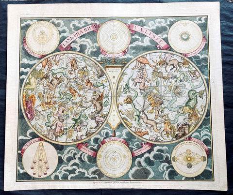
1720 Homann, Doppelmayr & Eimmart Antique Twin Hemisphere Celestial Chart, Map. Planisphaerium Caeleste
- Title : Planisphaerium Caeleste
- Ref #: 27010
-
Condition: (A+) Fine Condition
- Size: 25in x 21 1/2in (635m x 545mm)
- Date : 1720
- Price: $2750.00US
Description:
This magnificent original hand coloured copper plate engraved antique double hemisphere celestial chart, showing constellations of the northern and southern hemispheres depicted as allegorical figures, animals and scientific instruments after Georg Christoph Eimmart (1638-1705) was published by Johann Baptist Homann and Johann Gabriel Doppelmayr (1677-1750) in ca 1720.
The stars are shown in six degrees of magnitude according to a key in the center between the hemispheres. The selection and style of the constellations followed that of Firmamentum Sociescianum sive Uranographia (1687) by the Polish astronomer Johannes Hevelius, whose name is noted in the subtitle of the chart. The subtitle further indicates that the chart also draws on the work of Edmund Halley, the British astronomer for whom Halley’s Comet is named. There are numerous variants of this chart published in Germany in the 18th century; this example, Planispaerium Caeleste by Homann, bears the name of the firm (Officina Homanniana) under the border in the lower margin, together with the name of Georg Christoph Eimmart (1638-1705), the Nuremberg astronomer.
General Definitions:
Paper thickness and quality: - Heavy and stable
Paper color : - off white
Age of map color: - Original
Colors used: - Yellow, green, blue, pink
General color appearance: - Authentic
Paper size: - 25in x 21 1/2in (635m x 545mm)
Plate size: - 23in x 19 1/2in (585mm x 495mm)
Margins: - Min 1/2in (12mm)
Imperfections:
Margins: - None
Plate area: - None
Verso: - None
Background:
The outer borders of the chart are decorated with six inset diagrams against a background of clouds including the planetary models of Tycho Brahe, Ptolemy, and Copernicus. The other 3 diagrams show the illumination of the moon by the sun, the revolution of the earth around the sun, and the effect of the moon on tides.
Various firms in Amsterdam, Nuremberg and Augsburg published double hemisphere constellation charts based on the work of George Eimmart titled Planispaerium Caeleste or Planisphaerium Coeleste during the first eight decades of the 18th century, which can be divided fundamentally into two different versions. The prolific Nuremberg publisher Johann Baptist Homann first published Planispaerium Caeleste in his Neuer Atlas in 1707, bearing the inscription Opera G.C. Eimmarti. prostat in Officina Homanniana, meaning Work of Georg Christoph Eimmart offered for sale by the Homann Workshop. That chart has six inset diagrams. Scholar Robert H. van Gent notes the existence of similar prints of this format published by de Wit, Funck, Schenck, and Lotter, as well as by R. & J. Ottens in Amsterdam. The other versions vary more considerably with the inclusion of a seventh inset diagram and a figural illustration in the upper center. These include ones published by Melchior Rein in Augsburg and by Georg Matthäus Seutter (1647–1756) in Nuremberg.
Johann Gabriel Doppelmayr and Johann Baptist Homann were frequent collaborators in producing celestial and astronomical charts for atlases published by Homann and issued under various titles. The major two compilations of Dopplemayr’s works were published by Homann Heirs: Atlas Coelestis in quo Mundus Spectabilis et in Eodem Stellarum Omnium Phoenomena Notabilia, issued as 30 plates in 1742, and the revised edition of this work Atlas Novus Coelestis, in quo Mundus Spectabilis, et in Eodem tam Errantium quam Inerrantium Stellarum Phoenomena Notabilia, issued in 1748 (with an additional plate depicting the solar eclipse of 1748).
Nonetheless, these charts have a complicated publishing history that is not fully known. Some of these charts had appeared in earlier Homann editions such as his first atlas, the Neuer Atlas (Nuremberg: 1707), Atlas von Hundert Charten (Nuremberg: 1712), Grossen Atlas (Nuremberg: 1716), and Atlas Portatilis Coelestis (Nuremberg: 1723). Homann also issued geographical maps in various atlases that may have included celestial plates (particularly composite atlases), and Homann and his heirs presumably sold separately issued maps. Further, three additional celestial and astronomy plates have been located in at least one Homann celestial compilation atlas (1742, 1748, or later), though not among the 30 maps of the standard issue of Atlas Coelestis in quo Mundus Spectabilis, namely Sphaerarum Artificialium Typica Repraesentatio (globes and armillary sphere), Neu invertirte Geographische Universal (clock), and Planisphaerium Caeleste (double hemisphere celestial chart).
Doppelmayr, a professor of mathematics at the Aegidien Gymnasium at Nuremberg, was an acclaimed German geographer and astronomer who wrote on astronomy, geography, cartography, trigonometry, sundials and mathematical instruments. He was also involved in the production of globes as part of a larger goal to bring the scientific ideas of the Enlightenment to a broader public. In service of that idea, Doppelmayr translated several works into German including Nicholas Bion’s 1699 work L’usage des globes célestes et terrestes, et des sphères [The Usage of Celestial and Terrestrial Globes and of Spheres]. Doppelmayr was elected to several scientific societies, including the Berlin Academy of Sciences, the Royal Society and the St. Petersburg Academy of Sciences.
Please note all items auctioned are genuine, we do not sell reproductions. A Certificate of Authenticity (COA) can be issued on request.
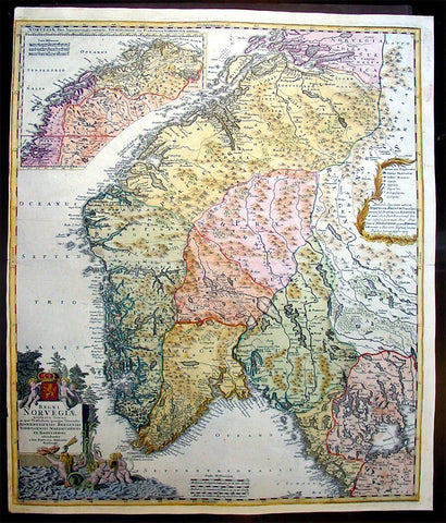
1720 Homann Large Antique Map of Norway
- Title : Regni Norvegiae Accurata Tabula in qua Praefecturae Quinque Generales Aggerhusiensis, Bergensis Nidrosiensis, Wardhusiensis et Bahusiensi Ioh. Bapt. Homanno.
- Date : 1720
- Condition: (A+) Fine Condition
- Ref: 16343
- Size: 23 3/4in x 20 1/4in (600mm x 515mm)
Description:
This large beautifully hand coloured original antique map of Norway & parts of Scandinavia - with an inset map of Lapland & Northern Norway - by Johann Baptist Homann was published 1720.
Background:
Before the fifteenth century the peoples of Southern Europe had little geographical knowledge of the Scandinavian world except from sketchy detail shown in the Catalan Atlas (1375) and on a number of 'portolani' embracing Denmark and the southern tip of Norway. It was not until 1427 that a manuscript map prepared about that time by Claudius Clavus (b. 1388), a Dane who had spent some time in Rome, made available to scholars a tolerable outline of the northern countries and Greenland. That was to remain the best map available for the rest of the century and it was used as the basis for maps of Scandinavia in early printed editions of Ptolemy. Others by Nicolaus Cusanus (1491) and Ehrhard Etzlaub (c. 1492) followed but, needless to say, these are extremely rare; even the later maps by Olaus Magnus and Marcus Jordan, where they have survived at all, are known only by very few examples. In fact, apart from the rare appearance of an early Ptolemy map, the oldest of Scandinavia which a collector is likely to find are those in Munster'sCosmography published in 1544 with many later editions. In the following centuries the comparatively few maps and charts compiled in Scandinavia were usually published in Amsterdam, Antwerp, Paris or Nuremberg, the more important maps often being incorporated in the major Dutch, French and German atlases. (Ref: Tooley; M&B)
General Description:
Paper thickness and quality: - Heavy and stable
Paper color: - off white
Age of map color: - Original
Colors used: - Yellow, green, blue, pink
General color appearance: - Authentic
Paper size: - 23 3/4in x 20 1/4in (600mm x 515mm)
Plate size: - 23 1/4in x 19 1/2in (590mm x 495mm)
Margins: - Min 1/8in (2mm)
Imperfections:
Margins: - Left margin cropped close to border
Plate area: - Horizontal crease parallel to centrefold
Verso: - None
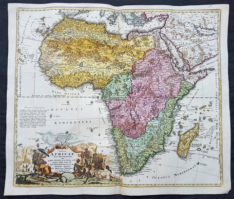
1715 Homann Original Antique Map of Africa - Origins of the Nile River, Heinrich Scherer
- Title : Totius Africae Nova Repraesentatio qua praeter diversos in ea Status et Regiones, etiam Origo Nili ex veris RRPP Missionariorum Relationibus ostenditur" Johann Baptist Homann
- Date : 1715
- Condition: (A+) Fine Good Condition
- Ref: 70820
- Size: 24in x 20 1/2in (610mm x 520mm)
Description:
This beautiful, large original hand coloured antique map of Africa, 1st edition, by JB Homann was published in 1715.
Handsome, large map of the continent with the typical inaccuracies of eighteenth century cartography. The map conforms to the twin lake configuration for the source of the Nile and a lengthy paragraph on the map purports to provide evidence of the accuracy of this theory based on the work of Heinrich Scherer. The geographical features are identical to the map that Johann engraved for Jacob von Sandrart, circa 1697, prior to Homann establishing his own publishing firm. The political boundaries and the large title cartouche are different. The cartouche is filled with interesting imagery including the pyramids, ivory trading, the source of the Nile, a troop of monkeys (throwing rocks at their hunters), kings, chiefs and warriors, a fat-tailed sheep with its tail supported by a wagon, and cherubs bringing salvation to the continent.
General Definitions:
Paper thickness and quality: - Heavy and stable
Paper color : - off white
Age of map color: - Original & later
Colors used: - Yellow, green, blue, pink
General color appearance: - Authentic
Paper size: - 24in x 20 1/2in (610mm x 520mm)
Plate size: - 22 1/2in x 19 1/4in (570mm x 490mm)
Margins: - Min 1/2in (12mm)
Imperfections:
Margins: - None
Plate area: - None
Verso: - Centerfold re-enforced on verso
Background:
Being part of the Mediterranean world, the northern coasts of the African continent as far as the Straits of Gibraltar and even round to the area of the Fortunate Isles (the Canaries) were reasonably well known and quite accurately mapped from ancient times. In particular, Egypt and the Nile Valley were well defined and the Nile itself was, of course, one of the rivers separating the continents in medieval T-O maps. Through Arab traders the shape of the east coast, down the Red Sea as far as the equator, was also known but detail shown in the interior faded into deserts with occasional mountain ranges and mythical rivers. The southern part of the continent, in the Ptolemaic tradition, was assumed to curve to the east to form a land-locked Indian Ocean. The voyages of the Portuguese, organized by Henry the Navigator in the fifteenth century, completely changed the picture and by the end of the century Vasco da Gama had rounded the Cape enabling cartographers to draw a quite presentable coastal outline of the whole continent, even if the interior was to remain largely unknown for the next two or three centuries.
The first separately printed map of Africa (as with the other known continents) appeared in Munster\'s Geographia from 1540 onwards and the first atlas devoted to Africa only was published in 1588 in Venice by Livio Sanuto, but the finest individual map of the century was that engraved on 8 sheets by Gastaldi, published in Venice in 1564. Apart from maps in sixteenth-century atlases generally there were also magnificent marine maps of 1596 by Jan van Linschoten (engraved by van Langrens) of the southern half of the continent with highly imaginative and decorative detail in the interior. In the next century there were many attractive maps including those of Mercator/Hondius (1606), Speed (1627), Blaeu (1 630), Visscher (1636), de Wit (c. 1670), all embellished with vignettes of harbours and principal towns and bordered with elaborate and colourful figures of their inhabitants, but the interior remained uncharted with the exception of that part of the continent known as Ethiopia, the name which was applied to a wide area including present-day Abyssinia. Here the legends of Prester John lingered on and, as so often happened in other remote parts of the world, the only certain knowledge of the region was provided by Jesuit missionaries. Among these was Father Geronimo Lobo (1595-1678), whose work A Voyage to Abyssinia was used as the basis for a remarkably accurate map published by a German scholar, Hiob Ludolf in 1683. Despite the formidable problems which faced them, the French cartographers G. Delisle (c. 1700-22), J. B. B. d\'Anville (1727-49) and N. Bellin (1754) greatly improved the standards of mapping of the continent, improvements which were usually, although not always, maintained by Homann, Seutter, de Ia Rochette, Bowen, Faden and many others in the later years of the century. (Ref: Tooley; M&B)
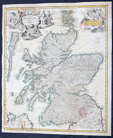
1720 JB Homann Large Antique Map of Scotland
- Title : Magnae Britannia Pars Septentrionalis Regnum Scotiae....Johan. Bapt. Homanno
- Ref #: 33663
- Size: 24in x 20in (610mm x 515mm)
- Date : 1720
- Condition: (A) Very Good Condition
Description:
This large original hand coloured copper plate engraved antique map of Scotalnd by JB Homann firm was published in 1720.
General Definitions:
Paper thickness and quality: - Heavy and stable
Paper color : - off white
Age of map color: - Original
Colors used: - Blue, red, yellow
General color appearance: - Authentic
Paper size: - 24in x 20in (610mm x 515mm)
Plate size: - 23in x 19in (585mm x 485mm)
Margins: - Min 1/2in (12mm)
Imperfections:
Margins: - Light soiling
Plate area: - Light soiling and dis-colouration in 4 small areas of image
Verso: - Backed onto contemporary paper
Background:
The Treaty of Perpetual Peace was signed in 1502 by James IV of Scotland and Henry VII of England. James married Henrys daughter, Margaret Tudor. James invaded England in support of France under the terms of the Auld Alliance and became the last British monarch to die in battle, at Flodden in 1513. In 1560, the Treaty of Edinburgh brought an end to the Anglo-French conflict and recognized the Protestant Elizabeth I as Queen of England. The Parliament of Scotland met and immediately adopted the Scots Confession, which signaled the Scottish Reformations sharp break from papal authority and Catholic teaching. The Catholic Mary, Queen of Scots was forced to abdicate in 1567.
In 1603, James VI, King of Scots inherited the thrones of the Kingdom of England and the Kingdom of Ireland in the Union of the Crowns, and moved to London. The military was strengthened, allowing the imposition of royal authority on the western Highland clans. The 1609 Statutes of Iona compelled the cultural integration of Hebridean clan leaders. With the exception of a short period under the Protectorate, Scotland remained a separate state, but there was considerable conflict between the crown and the Covenanters over the form of church government. The Glorious Revolution of 1688–89 saw the overthrow of King James VII of Scotland and II of England by the English Parliament in favour of William III and Mary II In common with countries such as France, Norway, Sweden and Finland, Scotland experienced famines during the 1690s. Mortality, reduced childbirths and increased emigration reduced the population of parts of the country about 10-15%.
In 1698, the Company of Scotland attempted a project to secure a trading colony on the Isthmus of Panama. Although it received a huge investment, the Darien scheme failed, partially due to English hostility. Along with the threat of an English invasion, the resulting bankruptcies played a leading role in convincing the Scots elite to back a union with England. On 22 July 1706, the Treaty of Union was agreed between representatives of the Scots Parliament and the Parliament of England. The following year twin Acts of Union were passed by both parliaments to create the united Kingdom of Great Britain with effect from 1 May 1707 with popular opposition and anti-union riots in Edinburgh, Glasgow, and elsewhere.
With trade tariffs with England now abolished, trade blossomed, especially with Colonial America. The clippers belonging to the Glasgow Tobacco Lords were the fastest ships on the route to Virginia. Until the American War of Independence in 1776, Glasgow was the worlds premier tobacco port, dominating world trade. The deposed Jacobite Stuart claimants had remained popular in the Highlands and north-east, particularly amongst non-Presbyterians, including Roman Catholics and Episcopalian Protestants. However, two major Jacobite risings launched in 1715 and 1745 failed to remove the House of Hanover from the British throne. The threat of the Jacobite movement to the United Kingdom and its monarchs effectively ended at the Battle of Culloden, Great Britains last pitched battle.
The Scottish Enlightenment and the Industrial Revolution turned Scotland into an intellectual, commercial and industrial powerhouse so much so Voltaire said We look to Scotland for all our ideas of civilisation. With the demise of Jacobitism and the advent of the Union, thousands of Scots, mainly Lowlanders, took up numerous positions of power in politics, civil service, the army and navy, trade, economics, colonial enterprises and other areas across the nascent British Empire. Historian Neil Davidson notes after 1746 there was an entirely new level of participation by Scots in political life, particularly outside Scotland. Davidson also states far from being peripheral to the British economy, Scotland – or more precisely, the Lowlands – lay at its core. In the Highlands, clan chiefs gradually started to think of themselves more as commercial landlords than leaders of their people. These social and economic changes included the first phase of the Highland Clearances and, ultimately, the demise of the clan system. In the last third of the 18th century, Highlanders began to migrate seasonally to Lowland cities for work, and emigration to the New World from both the Highlands and Lowlands became commonplace, even as the population increased
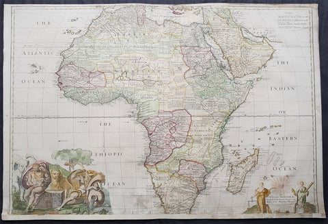
1720 John Senex Large Original Antique Map of Africa - Dedicated to Isaac Newton
- Title : Africa Corrected from the Observations of the Royal Society of London and Paris by John Senex
- Date : 1720
- Size: 40in x 27in (1.10m x 685mm)
- Ref #: 24893
- Condition: (B) Good Condition
Description: This very large, beautifully hand coloured and incredibly scarce original antique map of Africa was published by John Senex in the 1720 edition of his Elephant Folio General Atlas.
This large rare two sheet map provides a highly detailed look of the coastal regions along with the interior of Africa, at a time when it was still very much the Dark Continent. Also included are many annotations, including apocryphal notes regarding local peoples, animals, indigenous gems, mines, etc.
The map has undergone some restoration. These very large maps were subjected to adverse handling conditions over the centuries, making actual survival rare. This map has been backed onto archival Japanese tissue, with the bottom missing 1 1/2in re-enforced. This map sells normally retail up to $3500 (based on condition)
Condition Report:
Paper thickness and quality: - Heavy and stable
Paper colour: - Off white
Age of map colour: - Original & early
Colours used: - Yellow, pink, green
General colour appearance: - Authentic
Paper size: - 40in x 27in (1.10m x 685mm)
Plate size: - 38in x 27in (960mm x 685mm)
Margins: - Min 1/4in (5mm)
Imperfections:
Margins: - Bottom 1 1/2in of margin & image cropped
Plate area: - Soiling and several repairs to bottom of map adjacent to centerfold
Verso: - Backed with archival Japanese tissue, repairs as noted
Background: Good example of the large Senex map of Africa, dedicated to Sir Isaac Newton. " President of the Royal Society and Master of His Majesty's Mint." Newton served as President of the Royal Society from 1703 to 1727 and Master of the Mint from 1700 to 1727.
According to E.H. Lane-Pool, The Discovery of Africa . . . As Reflected in the Maps in the Collection of the Rhodes-LIvingstone Museum (1950)......."The dedication suggests that [Newton] was holding his post under Queen Anne, at the time the map was produced.. The topography is based on the later de L'Isle maps . . . the Portuguese discoveries inserted . . . much curious information is derived from the commentaries appended to the placenames. Of the Hensquas, a people inhabiting the country of Griquas, it is said, "This nations makes use of Lyons in fighting?' At the source of the Buffalo River is the note "This river is said to have no end." The Zimbas in what now is Nyasaland are "Anthropophagi or men-eaters who pay divine worship to their King", and Mount Chiri (near the Shire river) is aptly described as "very fertile and populous. " John Cassangi becomes established at the headwaters of the Cuneni River about this period. His town was a famous market for traders in transit from the interior, and was the limit of Portuguese Exploration from the West Coast. Seventy years later Cassangi was an embarrassment to the Portuguese on account of the embargo he placed upon trade between Mwatayamvu an the West Coast"
Being part of the Mediterranean world, the northern coasts of the African continent as far as the Straits of Gibraltar and even round to the area of the Fortunate Isles (the Canaries) were reasonably well known and quite accurately mapped from ancient times. In particular, Egypt and the Nile Valley were well defined and the Nile itself was, of course, one of the rivers separating the continents in medieval T-O maps. Through Arab traders the shape of the east coast, down the Red Sea as far as the equator, was also known but detail shown in the interior faded into deserts with occasional mountain ranges and mythical rivers. The southern part of the continent, in the Ptolemaic tradition, was assumed to curve to the east to form a land-locked Indian Ocean. The voyages of the Portuguese, organized by Henry the Navigator in the fifteenth century, completely changed the picture and by the end of the century Vasco da Gama had rounded the Cape enabling cartographers to draw a quite presentable coastal outline of the whole continent, even if the interior was to remain largely unknown for the next two or three centuries.
The first separately printed map of Africa (as with the other known continents) appeared in Munster's Geographia from 1540 onwards and the first atlas devoted to Africa only was published in 1588 in Venice by Livio Sanuto, but the finest individual map of the century was that engraved on 8 sheets by Gastaldi, published in Venice in 1564. Apart from maps in sixteenth-century atlases generally there were also magnificent marine maps of 1596 by Jan van Linschoten (engraved by van Langrens) of the southern half of the continent with highly imaginative and decorative detail in the interior. In the next century there were many attractive maps including those of Mercator/Hondius (1606), Speed (1627), Blaeu (1 630), Visscher (1636), de Wit (c. 1670), all embellished with vignettes of harbours and principal towns and bordered with elaborate and colourful figures of their inhabitants, but the interior remained uncharted with the exception of that part of the continent known as Ethiopia, the name which was applied to a wide area including present-day Abyssinia. Here the legends of Prester John lingered on and, as so often happened in other remote parts of the world, the only certain knowledge of the region was provided by Jesuit missionaries. Among these was Father Geronimo Lobo (1595-1678), whose work A Voyage to Abyssinia was used as the basis for a remarkably accurate map published by a German scholar, Hiob Ludolf in 1683. Despite the formidable problems which faced them, the French cartographers G. Delisle (c. 1700-22), J. B. B. d'Anville (1727-49) and N. Bellin (1754) greatly improved the standards of mapping of the continent, improvements which were usually, although not always, maintained by Homann, Seutter, de Ia Rochette, Bowen, Faden and many others in the later years of the century. (Ref: Tooley, Koeman)

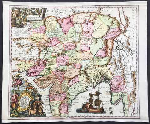
1720 Peter Vander AA Antique Map of Northern India - Mogul Empire
- Title : Royaume du Grand Mogol...Pierre Vander AA
- Ref #: 42004
- Size: 15in x 12 1/4in (370mm x 310mm)
- Date : 1720
- Condition: (A) Very good Condition
Description:
This beautifully hand coloured original antique map of Northern India, the Mogul Empire, was published by Peter Vander AA in 1720.
Finely engraved map of Northern India showing the mountains, rivers, cities, shrines, and roads. Lovely pictorial title cartouche, strapwork distance scales and compass rose embellish the map.
The Moghul Empire was founded in the northern part of India by Babur in 1526. It grew in size unitl the early 18th century, then slowly declined until it was finally dissolved by the British Empire in 1857.
While there was not a lot of interaction between Europe and the Moghuls in the seventeenth century, this important Asian empire was still of great fascination.
A 1618 map by William Baffin, based on the embassy of Sir Thomas Roe to emperor Jahangir in 1615, was the basis for a map of Willem Blaeu, which was then copied here by Blaeu's competitor Jan Jansson.
This is the more desirable version, as it contains a wonderful title cartouche showing two Moghul figures in elaborate dress. Also of interest are the small vignettes of elephants, lions, and a small camel caravan. (Ref: Koeman; Tooley) (Ref: M&B; Tooley)
General Description:
Paper thickness and quality: - Heavy & stable
Paper color: - Off white
Age of map color: - Early
Colors used: - Red, green, blue, brown
General color appearance: - Authentic
Paper size: - 15in x 12 1/4in (370mm x 310mm)
Plate size: - 14in x 11 1/2in (355mm x 290mm)
Margins: - Min 1/2in (12mm)
Imperfections:
Margins: - Age toning
Plate area: - Age toning and folds as issued
Verso: - Age toning
1724 Claude Delisle Large Antique Map of America, New Zealand Western Hemisphere
- Title : Hemisphere Occidental Dresse en 1720 pour l'usage
- Date : 1724
- Condition: (A+) Fine Condition
- Ref: 81075
- Size: 29 1/2in x 21in (750mm x 535mm)
Description:
This large beautifully hand coloured original copper-plate engraved antique map of the Western Hemisphere, including America & the west coast of New Zealand by Guillaume Delisle was engraved in 1724 - the date is engraved at the bottom of the map - by Joseph de la Haye and was published by in Atlas Nouveau.
Condition Report
Paper thickness and quality: - Very heavy and stable
Paper color: - Off white
Age of map color: - Original
Colors used: - Yellow, green, pink
General color appearance: - Authentic
Paper size: - 29 1/2in x 21in (750mm x 535mm)
Plate size: - 24in x 18 1/2in (610mm x 470mm)
Margins: - min. 1in (25mm)
Imperfections:
Margins: - None
Plate area: - None
Verso: - None
Background:
Claude de L isle was responsible for some of the most accurate maps of America avaialble in the early 18th century. Delisle did away with most of the speculative cartography especially of North America and researched his information in finite detail. This can be seen in many ways. The most oblivious is showing California as a Peninsular - which some cartographers did not believe until the 1740's - and the NW region has been left blank, free of speculation. Another noticeable difference is the accurate depiction of the Great Lakes. As with all Delisle's map this is finely engraved with amazing detail and hand colour. The map includes the tracks of many explorers up until 1710. These include Magellan 1520, Halley 1700, de Quiros 1605, de Mendana 1595, de la Maire 1616, Tasman, Halley and others. (Ref: M&B; Tooley)

1725 Campbell Antique Architectural Print of Greenhouse at Wanstead Manor Essex
- Title : The Greenhouse at Wanstead in Essex the Seat of Sir Richard Child Bart
- Ref #: 70547
- Size: 17in x 10 1/2in (430mm x 270mm)
- Date : 1725
- Condition: (A+) Fine Condition
Description:
This large original antique architectural print of the Greenhouse of the Great Manor House at Wanstead in Essex the home of Sir Richard Child by Colen Campbell and was published in the 1725 edition of Vitruvius Britannicus or The British Architect.
Background: In 1715 Sir Richard Child commissioned the Scottish architect Colen Campbell to design a grand mansion in the then emerging Palladian style, to replace the former house, and to rival contemporary mansions such as Blenheim Palace. When completed it covered an area of 260 ft (79 m). by 70 ft (21 m), the facade having a portico with six Corinthian columns, the earliest in England.
The grounds were landscaped and planted with formal avenues of trees by George London, one of the leading garden designers of his day. Child was created 1st Viscount Castlemaine 3 years later in 1718, the house being completed in 1722. Child had married in 1703 Dorothy Glynne, whose mother was of the Tylney family of Tylney Hall in Rotherwick, Hampshire.
On the death of Ann Tylney, her cousin, in 1730, Dorothy and her husband Viscount Castlemain inherited the Tylney estates. Castlemain was created 1st Earl Tylney the following year (1731) and in 1734 obtained an Act of Parliament to change the name of his family, including his heirs, from the patronymic to Tylney, probably to meet a condition of his wife's inheritance.
On the death of the Earl in 1750 he was succeeded by his 38-year-old son John Tylney, 2nd Earl Tylney, who continued the plantings, but in the then fashionable natural and non-formal style. The 2nd. Earl had no male issue and his estates passed on his death in 1784 to his elder sister Emma's sonSir James Long, 7th Baronet, who being then in possession of the vast estates of the Longs, the Childs and the Tylneys, assumed the surname Tylney-Long for himself and his descendants, again probably in accordance with a requirement of the inheritance.
On the death of the 7th Baronet in 1794 the combined estate passed to his one-year-old infant son Sir James Tylney-Long, 8th Baronet, who died in 1805 aged just 11. The estate then passed to his young sister, eldest of three, Catherine Tylney-Long, who thereby became the richest heiress in England.Like many other settlements, Wanstead first emerged into the light of history in the eleventh century, with the Domesday Survey, compiled on the orders of William I in 1086.
Vitruvius Britannicus or The British Architect is from one of the finest works on architecture ever produced. Colen Campbell published the work in London in 1725. The engravings from this work feature illustrations, plans, and cross sections of English country houses and parks.
Campbell was the chief architect to the Prince of Wales. His work served as a design book that led to the construction of many of Britain’s great houses. Vitruvius Britannicus established Palladian architecture as the dominant style England in the 18th century.
Vitruvius Britannicus documented the buildings of some of the greatest architects of the times including Indigo Jones, Sir Christopher Wren, and Colen Campbell himself. The work is essential to the study of 17th and 18th century design and architecture in England.
General Description:
Paper thickness and quality: - Heavy & stable
Paper color: - Off white
Age of map color: -
Colors used: -
General color appearance: -
Paper size: - 17in x 10 1/2in (430mm x 270mm)
Plate size: - 15in x 10in (380mm x 255mm)
Margins: - Min 1/2in (12mm)
Imperfections:
Margins: - Uniform age toning
Plate area: - Uniform age toning
Verso: - Uniform age toning
1730 Delisle Large Antique Map of South America
- Title : L Amerique Meridionale
- Date : 1730
- Condition: (A+) Fine Condition
- Ref: 60535
- Size: 24 1/2in x 21in (625mm x 535mm)
Description:
This large beautifully engraved hand coloured original antique map of South America by Guillaume Delisle was published by Covens and Mortier in the 1730 edition of Atlas Nouveau.
This important map of South America is cartographically unchanged from the 1st 1700 edition. The figures of Neptune and an Indian are incorporated into the title cartouche which was designed and engraved by Nicolas Guerard. The entire title cartouche is printed from a separate plate.
Also illustrated are the tracks of the explorers Sir Francis Drake, Olivier, Mendana, Le Maire Magellan and Sarmiento in the Pacific.
The southern extremity is shown curving to the west and the land extends to longitude 293°. (Ref: M&B; Tooley)
Condition Report
Paper thickness and quality: - Very heavy and stable
Paper color: - Off white
Age of map color: - Original & later
Colors used: - Yellow, green, pink
General color appearance: - Authentic
Paper size: - 24 1/2in x 21in (625mm x 535mm)
Plate size: - 23in x 19in (585mm x 480mm)
Margins: - min. 1in (25mm)
Imperfections:
Margins: - Light discolouration in bottom margin
Plate area: - None
Verso: - None
1730 Georg M Seutter Original Antique Map of America, Island of California
- Title : Novus Orbis sive America Meridionalis et Septentrionalis
- Date : 1730
- Size: 23 3/4in x 21in (605mm x 535mm)
- Ref #: 70793
- Condition: (A+) Fine Condition
Description:
This large handsome and beautifully hand coloured original antique map of America - showing California as an Island - was published by Georg Mattraus Seutter in 1730.
One of the best examples of this map I have seen to date with exceptional hand colouring.
General Definitions:
Paper thickness and quality: - Heavy and stable
Paper color : - off white
Age of map color: - Original & later
Colors used: - Yellow, green, blue, pink
General color appearance: - Authentic
Paper size: - 23 3/4in x 21in (605mm x 535mm)
Plate size: - 23in x 20in (585mm x 510mm)
Margins: - Min 1/2in (12mm)
Imperfections:
Margins: - None
Plate area: - Light spotting bottom right of map
Verso: - None
Background:
This is a highly decorative and informative map based on the contemporary European knowledge of America at the beginning of the 18th century. California is shown as an island based on the Sanson-Homann model but with additions including several more rivers on the west coast and two mountains to the north - M. Neges and M.S. Martin and C de Fortuna, C&R de Pins and many others.
The great lakes still show a large degree of ignorance to both shape and location and the NW is left blank. Brazil and the east coast of South America is still largely exaggerated.
The tracks of the early navigators are shown in the Pacific including Fr. Quir, Magellan, Drake and others.
The map also supports two large and highly decorative uncoloured - as published - cartouches which in themselves tell a story of European conquest and ignorance of the local populations.
Religion was a compelling motivation for European imperialism, and the opportunity to convert \"heathen\" Indians provided both a justification and means to conquer the indigenous peoples of the New World. Two Indians kneel reverently before a female figure representing Christianity in the top cartouche, flanked on the right by an altar prepared for Holy Communion and on the left by Europeans at a dining table.
The lower cartouche portrays tranquil Indians surrounded by standard symbols representing the Americas. The seated figure wears a feathered headdress, armband, and skirt. A servant shades him from the sun with a baldachin (parasol), while others in the background and to the left harvest what appears to be sugarcane and tobacco. In the center background someone rests in a hammock suspended between two palm trees while another rows quietly out to sea. A pelican, a cockatiel, and whimsical flying fish, some sporting saw-like beaks, hover above the title. The latter creatures appear to be the artist\'s misconception of a sawfish.
The placement of the two scenes illustrating this work is significant. By depicting numerous symbols associated with Roman Catholicism above a scene of Indians, a subtle message is conveyed: European contact with Indians would yield vast spiritual riches in the form of Christian converts and benefit the indigenous people, who, because they did not practice a Christian faith, were \"beneath\" those who did. (Ref: M&B; Tooley)
1730 Homann Large Antique Map Straits of Gibraltar Cadiz, Morocco, Malaga, Spain
- Title : Carte nouvelle de l'Isle de Cadix & du Detroit de Gibraltar
- Date : 1730
- Condition: (A) Very Good Condition
- Ref: 43157
- Size: 24 1/2in x 21in (620mm x 530mm)
Description:
This large beautifully hand coloured extremely attractive original antique map of the Strait of Gibraltar, Cadiz & southern Spain and Morocco, North Africa was published by Johann Baptiste Homann in 1730.
Background: This map of the Strait of Gibraltar was a collaborative effort between Jean de Petit (royal engineer and architect), Johann Friedrich Weidler (mathematician and astronomer at Witenberg), R.A. Schneider (engraver) and Johann Baptist Homann (publisher).
The map covers the tips of southern Spain and northern Africa in great detail showing forts, cities, farms, mountains, local roads and rivers. The numerous fortifications guarding this strategic waterway are the focus of the map, which is richly adorned with a brilliant compass rose, three large sailing ships and a fine title cartouche. (Ref: Tooley; M&B)
General Description:
Paper thickness and quality: - Heavy and stable
Paper color: - off white
Age of map color: - Original
Colors used: - Yellow, green, blue, pink
General color appearance: - Authentic
Paper size: - 24 1/2in x 21in (620mm x 530mm)
Plate size: - 22 1/2in x 19 1/2in (570mm x 490mm)
Margins: - Min 1in (25mm)
Imperfections:
Margins: - Light age toning left margin
Plate area: - None
Verso: - None
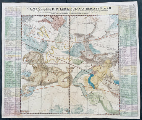
1730 J G Dopplemayr & J B Homann Large Antique Celestial Map Mythology & Zodiac
-
Title : Globi Coelestis In Tabulas Planas Redacti Pars II
- Ref #: 17031
-
Condition: (B) Good Condition
- Size: 23 1/2in x 20 1/4in (600mm x 515mm)
- Date : 1730
- Price: $425.00US
Description:
This large original copper plate engraved hand coloured antique celestial chart was engraved by Johann Gabriel Doppelmayr in 1730 - the date is engraved in the title - and was published by JB Homann in Atlas Coelestis.
This is the second chart in a series of six depicting part of the night sky on a gnomonic projection with the fixed stars for the end of the year of Christ 1730 according to the rules of arithmetic and geometry.
General Definitions:
Paper thickness and quality: - Heavy and stable
Paper color : - off white
Age of map color: - Original
Colors used: - Yellow, green, blue, pink
General color appearance: - Authentic
Paper size: - 23 1/2in x 20 1/4in (600mm x 515mm)
Plate size: - 23in x 19 1/2in (590mm x 495mm)
Margins: - Min 1/2in (12mm)
Imperfections:
Margins: - Age toning in margins, light creasing
Plate area: - Creasing and discolouration
Verso: - Creasing and age toning
Background:
The constellations are shown as figures according to classical mythology and the zodiac as derived from Hevelius. The more recently named constellations are shown as scientific instruments. The paths of several comets are traced following a pattern established by Pardies.
Specifically this chart is an internal view of the sky centred on the vernal equinox in a gnomonic projection between the declinations 45° North and 45° South. Also depicted are the paths of the comets C/1577 V1 (observed by Tycho Brahe), C/1585 T1 (Tycho Brahe), C/1590 E1 (Tycho Brahe), C/1664 W1 (Giovanni Domenico Cassini), C/1665 F1 (Johannes Hevelius), C/1672 E1 (Giovanni Domenico Cassini), C/1677 H1 (Johannes Hevelius), C/1680 V1 (John Flamsteed) and C/1683 O1 (Johannes Hevelius).
Doppelmayr wrote on astronomy, geography, cartography, spherical trigonometry, sundials and mathematical instruments. He often collaborated with the cartographer Johann Baptista Homann (1664-1724), a former Dominican monk from Oberkammlach in Schwabia who in 1688 had settled in Nuremberg and became a map engraver for the publishing firms of Jacob von Sandrart and David Funck.
In 1702, Homann founded an influential cartographic publishing firm that after his death was continued by his son Johann Christoph Homann (1703-1730) and after the latters death by his friend Johann Michael Franz (1700-1761) and his stepsisters husband Johann Georg Ebersberger (1695-1760) under the name Homännische Erben. The publishing firm remained in business under different names until 1848. (Ref: Adelung, J.Chr., Johann Gabriel Doppelmayr; Cantor, M., Johann Gabriel Doppelmayr)
Please note all items auctioned are genuine, we do not sell reproductions. A Certificate of Authenticity (COA) can be issued on request.
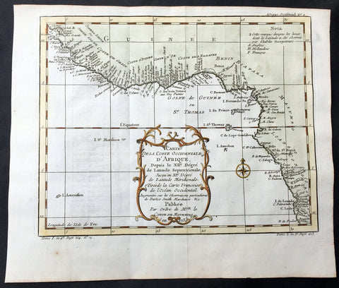
1739 Bellin Original Antique Map The West Coast of Africa - Senegal to Cameroon
- Title : Carte de la Coste Occidentale D Afrique...1739
- Date : 1739
- Size: 11 1/2in x 10in (290mm x 255mm)
- Ref #: 60910
- Condition: (A+) Fine Condition
Description:
This fine large, original copper-plate engraved antique map of The West Coast of Africa - from Senegal to Cameroon by Jacques Nicolas Bellin in 1739 was published in Antoine François Prevosts 15 volumes of Histoire Generale des Voyages written by Prevost & other authors between 1746-1790.
General Definitions:
Paper thickness and quality: - Heavy and stable
Paper color : - off white
Age of map color: - Early
Colors used: - Green, Yellow,
General color appearance: - Authentic
Paper size: - 11 1/2in x 10in (290mm x 255mm)
Plate size: - 10 1/2in x 8in (265mm x 205mm)
Margins: - Min 1/2in (6mm)
Imperfections:
Margins: - None
Plate area: - None
Verso: - None
Background:
One of Antoine Francois Prevosts monumental undertakings was his history of exploration & discovery in 15 volumes titledHistoire Générale des Voyages written between 1746-1759 and was extended to 20 volumes after his death by various authors.
The 20 volumes cover the early explorations & discoveries on 3 continents: Africa (v. 1-5), Asia (v. 5-11), and America (v. 12-15) with material on the finding of the French, English, Dutch, and Portugese.
A number of notable cartographers and engravers contributed to the copper plate maps and views to the 20 volumes including Nicolas Bellin, Jan Schley, Chedel, Franc Aveline, Fessard, and many others.
The African volumes cover primarily coastal countries of West, Southern, and Eastern Africa, plus the Congo, Madagascar, Arabia and the Persian Gulf areas.
The Asian volumes cover China, Korea, Tibet, Japan, Philippines, and countries bordering the Indian Ocean.
Volume 11 includes Australia and Antarctica.
Volumes 12-15 cover voyages and discoveries in America, including the East Indies, South, Central and North America.
Volumes 16-20 include supplement volumes & tables along with continuation of voyages and discoveries in Russia, Northern Europe, America, Asia & Australia.
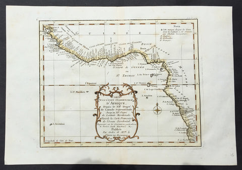
1739 Bellin Original Antique Map The West Coast of Africa - Senegal to Cameroon
- Title : Carte de la Coste Occidentale D Afrique...1739
- Date : 1739
- Size: 11 1/2in x 10in (290mm x 255mm)
- Ref #: 92510
- Condition: (A+) Fine Condition
Description:
This fine large, original copper-plate engraved antique map of The West Coast of Africa - from Senegal to Cameroon by Jacques Nicolas Bellin in 1739 was published in Antoine François Prevosts 15 volumes of Histoire Generale des Voyages written by Prevost & other authors between 1746-1790.
General Definitions:
Paper thickness and quality: - Heavy and stable
Paper color : - off white
Age of map color: - Early
Colors used: - Green, Yellow,
General color appearance: - Authentic
Paper size: - 11 1/2in x 10in (290mm x 255mm)
Plate size: - 10 1/2in x 8in (265mm x 205mm)
Margins: - Min 1/2in (6mm)
Imperfections:
Margins: - None
Plate area: - None
Verso: - None
Background:
One of Antoine Francois Prevosts monumental undertakings was his history of exploration & discovery in 15 volumes titledHistoire Générale des Voyages written between 1746-1759 and was extended to 20 volumes after his death by various authors.
The 20 volumes cover the early explorations & discoveries on 3 continents: Africa (v. 1-5), Asia (v. 5-11), and America (v. 12-15) with material on the finding of the French, English, Dutch, and Portugese.
A number of notable cartographers and engravers contributed to the copper plate maps and views to the 20 volumes including Nicolas Bellin, Jan Schley, Chedel, Franc Aveline, Fessard, and many others.
The African volumes cover primarily coastal countries of West, Southern, and Eastern Africa, plus the Congo, Madagascar, Arabia and the Persian Gulf areas.
The Asian volumes cover China, Korea, Tibet, Japan, Philippines, and countries bordering the Indian Ocean.
Volume 11 includes Australia and Antarctica.
Volumes 12-15 cover voyages and discoveries in America, including the East Indies, South, Central and North America.
Volumes 16-20 include supplement volumes & tables along with continuation of voyages and discoveries in Russia, Northern Europe, America, Asia & Australia.
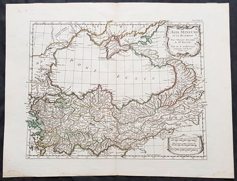
1740 J B D Anville Antique Map Gulf Of The Black Sea, Turkey, Crimea & Armenia
- Title : L Asie Mineure Et Le Bosphorepour L Histoire Ancienne de Mr Rollin...D Anville...1740
- Size: 16in x 13in (405mm x 330mm)
- Condition: (A+) Fine Condition
- Date : 1740
- Ref #: 70312
Description:
This magnificent original hand coloured copper-plate engraved antique map of The Black Sea, Turkey, Crimea & Armenia by Jean Baptiste Bourguignon D Anville in 1740 - dated - was published in Mr Charles Rollins Atlas. (Ref: M&B; Tooley)
General Definitions:
Paper thickness and quality: - Heavy and stable
Paper color : - off white
Age of map color: - Original
Colors used: - Blue, pink, red, green, yellow
General color appearance: - Authentic
Paper size: - 16in x 13in (405mm x 330mm)
Plate size: - 14in x 11 1/2in (355mm x 290mm)
Margins: - Min 1in (25mm)
Imperfections:
Margins: - None
Plate area: - None
Verso: - None
Background:
The Black Sea is a body of water and marginal sea of the Atlantic Ocean between Eastern Europe, the Caucasus, and Western Asia.[1] It is supplied by a number of major rivers, such as the Danube, Dnieper, Southern Bug, Dniester, Don, and the Rioni. About a third of Europe drains into the Black Sea,[2] including the countries of Austria, Belarus, Bosnia and Herzegovina, Bulgaria, Croatia, Georgia, Germany, Hungary, Moldova, Poland, Romania, Russia, Serbia, Slovakia, Slovenia, Turkey and Ukraine.
1740 Seutter Large Antique Map of India, Mughal Empire, Tibet, Nepal
- Title : Imperii Magni Mogolis sive Indici Padschach, juxta recentiissimas Navigationes accurata delineato Geographica studio et sumtibus.
- Date : 1740
- Condition: (A+) Fine Condition
- Ref: 42008
- Size: 25in x 20 1/2in (630mm x 520mm)
Description:
This large beautifully hand coloured original antique map of India and the Northern Mughal Empire was published by Georg Mattraus Seutter in 1740.
Background:
Representing 18th century Germany cartography at it’s finest; this is an absolutely spectacular c. 1740 map of northern India by Matthias Seutter. Showing the extent of the powerful Mughal Empire in the late 17th century, this map details the subcontinent and parts of Central Asia from Persia and Khandhar eastward as far a modern day Burma and Thailand. Extends northward to include parts of Tibet and Nepal and southwards as far as the Malabar Coast and the Gulf of Thailand. Cartographically this map is heavily based upon Hondius and Mercator’s 17th century of the same region entitled India Orientalis. Presented is wonderful combination of surprising accuracy, gross errors, and outright speculation. Generally speaking, this map is cartographically solid detailing numerous cities, river systems and trade routes. Shows Deli, Agra, Kandahar (Candahar), Lahore (Lahor), Pegu, Goa, Kabul (Cabul), Jaisalmer (Gislemere), and many other important and still thriving cities. Also notes several important trade routes including the ancient caravan trail westward from Agra into Persia. Despite this map’s thoroughness, there are a number of cartographic errors, probably the most notable of which is the narrowing of the subcontinent. Usually such lateral misrepresentations are the result of erroneous 16th century longitudinal calculations. In this case, these errors found their way into the Hondius’s map and hence into this one as well. The northernmost regions depicted on this map are highly speculative with regard to physical geography. A number of large lakes, including the apocryphal Lake of Chiamay, are speculated in the northeastern quadrants of the map as the sources of four important Southeast Asian river systems including the Irrawaddy, the Dharla, the Chao Phraya, and the Brahmaputra. The curious Lake of Chiamay (also called Chiam-may or Chian-may), roughly located in the area of Assam but sometimes as far north as Tibet and China, began to appear in maps of this region as early as the 16th century and persisted well into the mid 18th century. Its origins are unknown but may originate in a lost 16th century geography prepared by the Portuguese scholar Jao de Barros. It was speculated to be the source of five important Southeast Asian River systems and was mentioned in the journals of Sven Hedin. There are even records that the King of Siam led an invasionary force to take control of the lake in the 16th century. Nonetheless, the theory of Lake Chimmay was ultimately disproved and it disappeared from maps entirely by the 1760s. Decorated with several extremely attractive allegorical cartouche image. The title cartouche in the lower left hand quadrant shows Poseidon, Hermes, an angel and the goddess Fame admiring the wealth of Asia as represented by jewels, ivory, and precious metals. In the upper left hand quadrant, a distance scale plays second fiddle to a scene of cherubs rummaging through chests full of treasure while exotic peacocks look on. A large trade Caravel rests in the Indian Ocean, lower right quadrant, suggesting the trade riches to be had by daring ship captains willing to sail half way around the world. Engraved by Albrecht Carl Seutter and published by Matthias Seutter c. 1740. (Ref: M&B; Tooley)
Condition Report
Paper thickness and quality: - Heavy and stable
Paper color: - off white
Age of map color: - Original & later
Colors used: - Yellow, pink, green, orange, blue
General color appearance: - Authentic
Paper size: - 25in x 20 1/2in (630mm x 520mm)
Plate size: - 22 1/2in x 20in (570mm x 500mm)
Margins: - Min 1/2in (12mm)
Imperfections:
Margins: - Bottom & top margin extended from plate-mark & border
Plate area: - None
Verso: - None
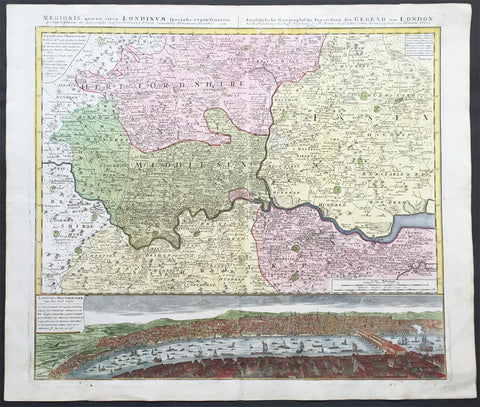
1741 Large Homann Antique Map of London Surrey - Birds Eye View of London
- Title : Regionis quae est circa Londinum....Homaniamus Heredibus 1741
- Date : 1741
- Condition: (A+) Fine Condition
- Ref: 92275
- Size: 25 ½in x 21 ½in (650mm x 550mm)
Description:
This beautifully hand coloured original antique map* of the Environs of London - Middlesex, Essex, Surrey and Kent - with a beautiful and a very real view of the city of London in the mid 18th century and the Thames - was engraved in 1741 - dated at the top of the map - and was published by the Homann firm.
A superb map with a deep heavy impression, stunning colour and sound heavy paper, a fine map.
Background: This map is based upon an earlier map of the region by Thomas Bowles and covers the London area from Berkshire (including Windsor Castle) in the west to Shamel in the east, extending north north as far as Bedford. Specifically focuses on Hertfordshire, Middlesex, Surrey, Essex and Kent. Offers extraordinary detail throughout, showing roadways, villages, London Streets, estates, and in many cases, individual homes. The lower portion of the sheet is dominated by a dramatic bird's-eye view of London and Westminster from Southwark across the Thames. View reveals a densely populated showing numerous boats, barges, and sailing vessels.
The beautifully hand coloured view of the city of London & Westminster was published only 90 odd years after the great fire of 1666.The view of London after Thomas Bowles, was one of a number published by Bowles and the Homann firm in the mid 18th century illustrating the growth and change of the great city.
The view is stunning, stretching from old London bridge & the docklands in the east to the farmlands to the west. What is really fascinating is the level of detail. There are a myriad of different sailing vessels occupying both sides of London bridge. The number of shops and residences that occupied the bridge at that time are uniquely displayed as is the number churches and cathedrals that dominate the skyline. To the right you can see the farm land that will one day become the West End and other upmarket areas of London.(Ref: M&B; Tooley)
General Description:
Paper thickness and quality: - Heavy and stable
Paper color: - off white
Age of map color: - Original & later color
Colors used: - Yellow, green, pink
General color appearance: - Authentic
Paper size: - 25 ½in x 21 ½in (650mm x 550mm)
Plate size: - 22 ½in x 20in (570mm x 510mm)
Margins: - Min ½in (12mm)
Imperfections:
Margins: - Light soiling in margins
Plate area: - None
Verso: - Bottom left plate-mark a little worn
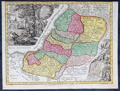
1744 Georg Mattaus Seutter Antique Map Holy Land, Palestine, Israel, XII Tribes
- Title : Terra Sancta vocata Quae, Olim XII Tribes........a Matth. Seutteri...T C Lotter, Geogr.
- Ref #: 93403
- Size: 11in x 8 1/2in (280mm x 215mm)
- Date : 1744
- Condition: (A+) Fine Condition
Description:
This beautifully hand coloured original copper-plate engraved antique map of The Holy Land was engraved by Tobias Lotter and was published in the 1744 edition of GM Seutters Atlas Minor Prae cipua Orbis Terrarum Imperia Regna et Provincias...., Augsburg, Germany.
General Definitions:
Paper thickness and quality: - Heavy and stable
Paper color : - off white
Age of map color: - Original
Colors used: - Yellow, green, blue, pink
General color appearance: - Authentic
Paper size: - 11in x 8 1/2in (280mm x 215mm)
Plate size: - 10 1/2in x 8in (265mm x 205mm)
Margins: - Min 1/4in (5mm)
Imperfections:
Margins: - None
Plate area: - None
Verso: - None
Background:
Atlas Minor was a series of beautiful maps of all parts of the world. Georg Matthäus Seutter was one of the most and important of the German cartographers of the 18th century, being appointed as the Geographer to the Imperial Court. His son, Albrecht Carl, joined Matthäus and eventually inherited the business. The maps from Atlas Minor were drawn by the two Seutters and engraved by Tobias Conrad Lotte. These maps are highly detailed and engraved with a bold hand with equally strong original hand color in the body of the map as was the 18th century German style. The cartouches were left uncolored in order to emphasize the elaborately detailed illustrations for which German maps are especially prized. These are some of the most decorative and interesting maps of the eighteenth century.
1745 Claude Delisle Large Antique Map of America - Magnificent Landmark Map
- Title : Carte D Amerique...Par Guillaume Delisle...1722
- Date : 1722 (1745)
- Condition: (A+) Fine Condition
- Ref: 50603
-
Size: 28in x 22in (710mm x 560mm)
This large, beautifully engraved, hand coloured original antique map of America, was published in 1722 by Claude de L'Isle (Delisle) and re-issued - cartographically unchanged - by Phillip Bauche in 1745 - both dates are engraved in the title cartouche and at the foot of the map. This is a landmark map and one of the most important maps of America published in the 18th century. So detailed was it, for its day, that it was copied many times over the next 100 years.
Condition Report
Paper thickness and quality: - Very heavy and stable
Paper color: - Off white
Age of map color: - Original
Colors used: - Yellow, green, pink
General color appearance: - Authentic
Paper size: - 28in x 22in (710mm x 560mm)
Plate size: - 24 ½in x 19 ½in (620mm x 495mm)
Margins: - Min 1in (25mm)
Imperfections:
Margins: - None
Plate area: - Toning along centrefold, professional restoration to small worm holes adjacent to Caribbean
Verso: - Toning along centrefold
Background: The map has an immense amount of detail regarding North America. In California and the Southwest the west coast is taken north to Cap Mendocin and Cap Blanc, with the notation, "Entrée decouverte par Martin d'Aguilar." Wagner notes "Briggs names with some of the corrections made by Blaeu. The Mediterranean Sea of California has disappeared. Delisle retained Cabrillo's B. de Pinos and introduced a few, the I. Ste Anne, the B. de St. Martin, and the B. de la Medelaine, from other maps. It seems likely that he had read the account of the Vizcaino expedition Torquemada... On the Sonora coast the names are much the same as those on his 1700 map with a few additions from Kino's map and other sources in Sonora. The course of the Mississippi is pushed considerably west of its true location, but the Missouri River is shown in a remarkably accurate fashion, with headwaters in the Northern Rocky Mountains. The look of the Great Lakes take on a more realistic form, the original Colonial States are represented and as can be expected from a French map of the period France through Louisiana claims most of south middle and north America. The map is rich with Indian and other early American details. (Ref: M&B; Tooley)
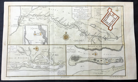
1745 D Anville & Childs Antique Map of Senegal, Fort St Louis, African Slavary
- Title : A General Map of The River Sanaga...Sr D Anville; A Map of the Entrance of the Sanaga; Island of Sanaga or St louis
- Date : 1745
- Size: 17 1/2in x 10in (440mm x 255mm)
- Ref #: 61152
- Condition: (A+) Fine Condition
Description:
This large hand coloured original copper-plate engraved antique map of Senegal and the Sanaga or Senegal River, along with a map of the entrance to the River and the Slave Island of Sanaga or St Louis after D Anville, by Graham Childs in 1745.
Background: These 3 maps are the key to a dark history of Slavery on the West Coast of Africa, in the country of Senegal. The first map shows the River of Senegal which would have been used to transport captured African slaves to the forts situated at the mouth of the river. These forts were used as holding stages for the captives, along with many others along the West African coast, prior to being transported to the Americas from the 16th to 18th centuries. (Ref: M&B; Tooley)
General Description:
Paper thickness and quality: - Heavy & stable
Paper color: - White
Age of map color: - Early
Colors used: - Yellow, pink, green
General color appearance: - Authentic
Paper size: - 17 1/2in x 10in (440mm x 255mm)
Plate size: - 15 1/2in x 9 1/2in (395mm x 240mm)
Margins: - Min 1/2in (12mm)
Imperfections:
Margins: - None
Plate area: - Folds as issued
Verso: - None

1745 George Anson Antique Mercators World Map, Island of California, New Holland
- Title : A Chart shewing The Track of the Centurion round the World
- Ref #: 16292
- Size: 19in x 10 1/2in (485mm x 265mm)
- Date : 1745
- Condition: (A+) Fine Condition
Description:
This fine original antique World Map centering on Australia and the Pacific - with North America & the Island of California - covering the route taken by Admiral George Anson & the ship the Centurion in his global voyage between 1740 & 1744.
The map was engraved by Richard Seale and was published in the English edition of Ansons book A Voyage round the World, in the Years MDCCXL, I, II, III,IV. The book was written by Richard Walter, Chaplin aboard Ansons flagship, Centurion.
In his famous voyage (1740–44) around the world, Anson, in spite of shipwrecks and scurvy, inflicted great damage on Spanish shipping and returned to England with a rich prize. He was raised to the peerage after his popular naval victory (1747) off Cape Finisterre. Appointed then as first lord of the admiralty, he assisted William Pitt, Lord Chatham, in reorganizing naval administration.
British navigators in the 1700`s were often interested in more than increasing the glory of God & Country. In September 1740 Commodore Anson set off across the Atlantic with six poorly manned, ill-equipped vessels to capture Spanish treasure ships in the Pacific. He lost three ships rounding Cape Horn but went on to raid Spanish mining settlements on the coast of Chili. Although he and his crew suffered incredible hardships while crossing the Pacific in their one remaining ship, the Centurion, Anson managed to capture a Spanish treasure galleon near the Philippines. He sold this prize for £400,000 in Canton, China, the Centurion being the first British warship to enter Chinese waters. By the time he reached England in June 1744, more than half the original crew of nearly 2,000 men had died, chiefly of scurvy. (Ref: Tooley)
General Description:
Paper thickness and quality: - Heavy & stable
Paper color: - White
Age of map color: -
Colors used: -
General color appearance: -
Paper size: - 19in x 10 1/2in (485mm x 265mm)
Plate size: - 16 1/2in x 9 1/2in (420mm x 245mm)
Margins: - Min 1/2in (12mm)
Imperfections:
Margins: - None
Plate area: - Light horizontal crease
Verso: - None
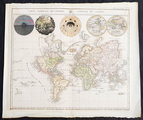
1745 Pieter Mortier Antique World Map with California as an Island
- Title : Carte Generale des Parties Connues du Globe
- Size: 21in x 17 1/2in (480mm x 340mm)
- Condition: (A+) Fine Condition
- Date : 1745
- Ref #: 93346
Description:
This large original copper-plate engraved antique World Map, on Mercators Projection, by Pieter Mortier, was first published in the late 17th century and was re-issued over the next 60 years in both Atlases and Bibles illustrating the world and the heavens, as understood in a century of huge change.
General Definitions:
Paper thickness and quality: - Heavy and stable
Paper color : - off white
Age of map color: -
Colors used: -
General color appearance: -
Paper size: - 21in x 17 1/2in (480mm x 340mm)
Plate size: - 21in x 17 1/2in (480mm x 340mm)
Margins: - Min 1in (25mm)
Imperfections:
Margins: - None
Plate area: - None
Verso: - Early mounting on contemporary paper
Background:
Finely engraved map, with California as an island with the Detroit d Anian in the west, connects by dotted lines, through the Northwest Passage to Button\'s Bay, which is located to the west of Hudson Bay. In North America there is an erroneous large lake shown as the source for the Rio Norte, which flows southwest and empties into the Gulf of California. In the Great Lakes region there is a large open-ended lake named Mer Douce. The northeast coast of Asia is severely truncated and shows Witsen\'s Cap de Glaces. A small coastline of New Zealand appears in the Pacific. Australia\'s northern coast is shown connected to New Guinea, and two disjointed coastlines appear to the south including Van Diemen\'s Land. Five spheres are presented along the top, depicting Day and Night, the Flood, the phases of the moon, and the Western and Eastern Hemispheres.
Mortier, Pieter 1661 - 1711
Mortier was an 18th-century mapmaker and engraver from the Northern Netherlands.
Mortier was born in Leiden. According to Houbraken, David van der Plas worked with Mortier on etchings for Bybelsche Tafereelen (Bible stories), published in Amsterdam in 1700. He was the father of Cornelis Mortier (1699–1783), who in partnership with Johannes Covens I (1697–1774) began the map publishing company Covens & Mortier (1721–1866). He won the privilege in 1690 of publishing maps and atlases by French publishers in Amsterdam. He also used this privilege to win a similar set of privileges for printing an illustrated print bible in 1700. He died in Amsterdam in 1711

1745 Tindal Antique Map of Spanish & Austrian Armies in Catalonia Spain in 1711
- Title : Plan of the Incampment of the Allies at Prats Del Rey. under the command of Count Staremberg and of ye Enemy under the Duke of Vendsome: wher ye two Armies lay from ye 17th of September to ye 25th of December 1711 N.S. when ye Enemy decamped and ye Allies the 27th.
- Size: 19 1/2in x 15 1/2in (495mm x 395mm)
- Ref #: 16430
- Date : 1745
- Condition: (A+) Fine Condition
Description:
This beautifully hand coloured original copper-plate engraved antique map, a battle plan of the encampments of the Spanish army under Louis-Joseph, duke de Vendome & the Austrian Army under Count Guido Starhemberg in Prado Del Rey in Catalonia, Spain - during the Spanish War of Succession (1701-13) - was engraved by John Basire and was published in the 1745 edition of Nicholas Tindals Continuation of Mr. Rapin\'s History of England.
General Definitions:
Paper thickness and quality: - Heavy and stable
Paper color : - off white
Age of map color: - Early
Colors used: - Pink, blue, green, yellow
General color appearance: - Authentic
Paper size: - 19 1/2in x 15 1/2in (495mm x 395mm)
Plate size: - 19 1/2in x 15 1/2in (495mm x 395mm)
Margins: - Min 1/2in (12mm)
Imperfections:
Margins: - None
Plate area: - Folds as issued
Verso: - None
Background:
Duke Louis-Joseph de Vendome , 1654 — 1712 was one of King Louis XIV’s leading generals during the War of the Spanish Succession (1701–14).
Vendome was the son of Louis de Vendome, Duke de Mercoeur, by his marriage to Cardinal Jules Mazarin’s niece, Laure Mancini. Vendôme entered the French Army in 1672 and had risen to the rank of lieutenant general by the outbreak of the War of the Grand Alliance (1689–97) between France and the other major powers. He distinguished himself in the victory over the Allies at Steenkirke (1692) and was made commander in Catalonia in 1695; two years later he captured Barcelona.
The dispute over the succession to the Spanish throne brought France and Spain to war with the British, the Austrians, and the Dutch in 1701. Appointed to the command in northern Italy in 1702, Vendôme fought the Austrian commander, Prince Eugene of Savoy, in the bloody but indecisive Battle of Luzzara on August 15. He took Vercelli in 1704 and defeated Prince Eugene at Cassano in August 1705. In May 1706 Vendôme was transferred to the Flanders front, where the British commander John Churchill, 1st Duke of Marlborough, had just won an overwhelming victory at Ramillies. Vendôme made limited gains until he was severely defeated by Marlborough and Prince Eugene at Oudenaarde on July 11, 1708. Vendôme subsequently failed to relieve besieged Lille (in northern France), which fell to the Allies in October. Recalled by Louis XIV, he was temporarily disgraced.
Guido Wald Rüdiger, count of Starhemberg1657 – 1737 was an Austrian military officer.
He was a cousin of Ernst Rudiger von Starhemberg (1638-1701), the famous commander of Vienna during the Turkish siege of 1683, and acted as his aide-de-camp during that siege. Guido followed his cousin, and later Prince Eugene of Savoy, in battles against the Turks.
In the War of the Spanish Succession, Starhemberg fought in Italy and Spain. Between 1706 and 1708 he was the commander-in-chief of the imperial army in Hungary, leading military operations against the insurgents of Francis II Rákóczi. In 1708, he was appointed Supreme Commander of the Austrians in Spain.
Together with James Stanhope he succeeded in conquering Madrid in 1710, after previously gaining victories at Almenar and Saragossa. In December, however, he was forced to leave the city by the lack of support by its inhabitants for the Habsburg pretender. After the subsequent defeats at the Battle of Brihuega and the Battle of Villaviciosa (1710), he had to pull back to Catalonia, where he was made viceroy when Archduke Charles returned to Austria.
After the Peace of Utrecht (1713), archduke Charles, now Emperor Charles VI, ordered him to abandon Catalonia. He pulled back with his troops to Genoa on English ships.
When he died in 1737, he was Governor of Slavonia
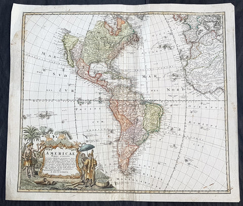
1746 Homann Large Antique Map of America
- Title : Americae Mappa generalis
- Size: 23in x 20in (595mm x 510mm)
- Condition: (B) Good Condition
- Date : 1746
- Ref #: 93345
Description:
Large original hand coloured antique map of America by the Homann Heirs, in 1746 (dated) published on the cusp of great change in North America in the mid to late 18th century.
General Definitions:
Paper thickness and quality: - Heavy and stable
Paper color : - off white
Age of map color: - Original & later
Colors used: - Blue, pink, red, green, yellow
General color appearance: - Authentic
Paper size: - 23in x 20in (595mm x 510mm)
Plate size: - 22in x 19in (500mm x 470mm)
Margins: - Min 1/2in (12mm)
Imperfections:
Margins: - Top left margin & border corner restored
Plate area: - Age toning, centerfold re-joined with light creasing
Verso: - Centerfold re-joined with light creasing
Background:
Homanns second map of America, which reflects the substantial new information obtained since the issuance of the first map of America by the patriarch of the Homann Family, Johann Baptiste Homann. The decorative cartouche includes some very lively visual imagery, including volcanos and a nice alegorical scene representing the people, flora and fauna of America.
The interior of North America benefits from the knowledge obtained by the Jesuits in the Interior parts of North America, especially along the Mississippi River and English and Dutch information along the coast. The French are still the dominant force in the North, the Spanish in the South, immediately prior to the French and Indian War. The Great Lakes are only just now being accurately charted by D\'Anville and later Mitchell. The west coast conforms to the French updates provided by De L\'Isle and progeny. South America is substantially corrected from earlier models.
The NW Coast of America and NW Passage are still unknown, but wishfully shown. Quivira is shown considerably east of its normal location. Quivira was the the legendary land of gold and silver. Francisco de Coronado began his search for Quivira in 1541, but found only Indian Villages. He did however report to the Spanish King that the land was suitable for growing all of the products of Spain. Quivira migrated progressively further North and East, until it disappeared in the late 18th Century. The map seems to be influenced primarily by the highly influential map of America by De L\'Isle first issued in 1700, although the Haas retains some of the great mythical cartographic features in the interior regions.
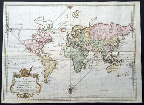
1748 J N Bellin Large Antique World Map on Mercators Projection - 1st edition
- Title : Essay d' une Carte Reduite Contenant les parties connuees Du Globe Terrestre
- Ref #: 50682
- Size: 27 1/4in x 19 3/4in (690mm x 500mm)
- Date : 1748
- Condition: (A+) Fine Condition
Description:
This large beautifully hand coloured original antique 1st edition World Map on Mercators projection by Jacques Nicolas Bellin was engraved in 1748 - dated in the cartouche - and published in 1750.
Background: First edition of Bellin's large four sheet joined, mid-18th century world map, published in Paris. This map pre-dates the major world discoveries of the late 18th century including Bay of the West coast of America, the discovery of the Sandwich Islands, and the Voyages of Capt Cook soon to map the East Coast of Australia & NZ.
This edition is most noteworthy for its marvellous early projection of Australia and New Zealand, each with largely speculative coastlines. Australia is still attached to New Guinea and has several notes of early exploration shown. New Zealand is barely known and with only a portion of its western coastline.
No sign of Antarctica and the NW Coast of America includes the first notes of Russian exploration.
In North America Bellin identifies the semi-mythical civilizations of Quivira and Teguayo, both associated with legends of the Seven Cities of Gold, in what is modern day Utah, California, and Nevada. Along the western coast the strait discovered by Martin Aguilar is noted. Further north still the River of the West (Fl. de l’Ouest) extends from the west coast to the Lake of the Woods (Lac de Bois) and thence via additional waterways to the Great Lakes and the Atlantic. The River of the West appeared in many 18th century maps of the Americas and is reflective of French hopes for a water route from their colonies in Canada and Louisiana to the Pacific. Still further north the coastline becomes extremely vague, in places vanishing altogether. The Aleutians are vaguely rendered according to various sightings by Vitus Jonassen Bering and Aleksei Chirikov in the 1740s and identified as the “Archipel de Nord”.
In the Pacific, various Polynesian Island groups are noted though many are slightly or significantly misplaced. The Solomon Islands are vastly oversized referencing the early 17th claims of Quiros. The other lands discovered and erroneously mapped by Quiros in 1606 and Davis in 1686 during their search of the great southern continent are also noted. Hawaii, as yet undiscovered, is absent. New Zealand is rendered twice though is accurate in its form and position. Australia, here labelled “Nouvelle Holland”, has part of its southern coastline ghosted in and Van Diemen’s Land (Tasmania) is attached to the mainland. The southern coast of New Guinea is similarly ghosted in, suggesting its unexplored state. (Ref: Tooley; M&B)
General Description:
Paper thickness and quality: - Heavy and stable
Paper color: - off white
Age of map color: - Later
Colors used: - Yellow, green, pink
General color appearance: - Authentic and fresh
Paper size: - 27 1/4in x 19 3/4in (690mm x 500mm)
Plate size: - 26 1/2n x 19in (670mm x 490mm)
Margins: - Min ½in (12mm)
Imperfections:
Margins: - Top left margin extended from plate-line
Plate area: - Folds as issued
Verso: - Folds as issued
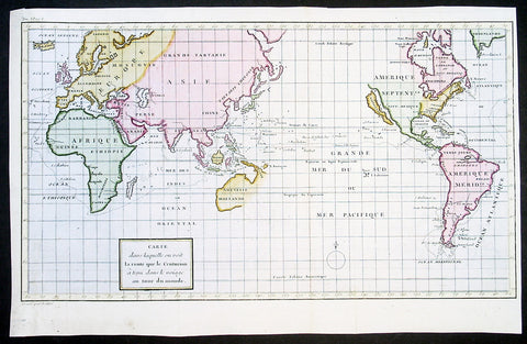
1750 Admiral George Anson & Lattre Large Antique World Map, California Island
-
Title : Carte dans laquelle on Voit la Route que le Centurion a Tenu dans la Voiage au tour du Monde
- Date : 1750
- Condition: (A+) Fine Condition
- Ref: 92607
- Size: 16 1/2in x 11in (420mm x 280mm)
Description:
This finely engraved beautifully hand coloured original antique World Map - showing California as an Island - illustrates the route taken by Admiral George Anson in his ship the Centurion in his global voyage of discovery between 1740 & 1744.
The map was engraved by Frenchman Jean Lattre in 1750 and was published in the French edition of Ansons book A Voyage round the World, in the Years MDCCXL, I, II, III,IV. The book was written by Richard Walter, Chaplin aboard Ansons flagship, Centurion.
In his famous voyage (1740–44) around the world, Anson, in spite of shipwrecks and scurvy, inflicted great damage on Spanish shipping and returned to England with a rich prize. He was raised to the peerage after his popular naval victory (1747) off Cape Finisterre. Appointed then as first lord of the admiralty, he assisted William Pitt, Lord Chatham, in reorganizing naval administration.
British navigators in the 1700`s were often interested in more than increasing the glory of God & Country. In September 1740 Commodore Anson set off across the Atlantic with six poorly manned, ill-equipped vessels to capture Spanish treasure ships in the Pacific. He lost three ships rounding Cape Horn but went on to raid Spanish mining settlements on the coast of Chili. Although he and his crew suffered incredible hardships while crossing the Pacific in their one remaining ship, the Centurion, Anson managed to capture a Spanish treasure galleon near the Philippines. He sold this prize for £400,000 in Canton, China, the Centurion being the first British warship to enter Chinese waters. By the time he reached England in June 1744, more than half the original crew of nearly 2,000 men had died, chiefly of scurvy. (Ref: Tooley)
General Description:
Paper thickness and quality: - Heavy & stable
Paper color: - White
Age of map color: - Early
Colors used: - Yellow, green, pink
General color appearance: - Authentic
Paper size: - 16 1/2in x 11in (420mm x 280mm)
Plate size: - 16 1/2in x 11in (420mm x 280mm)
Margins: - Min 1/2in (12mm)
Imperfections:
Margins: - None
Plate area: - Folds as issued, very light offsetting
Verso: - None
1750 Prevost & Schley Antique Print of Slave Fort Tantumquery, Otuam, Ghana, West Africa
- Title: Vue Sud Du Fort De Tantumquerri par Smith
- Date: 1750
- Condition : (A+) Fine Condition
- Ref: 25768
- Size: 14in x 10in (355mm x 255mm)
Description:
This fine original copper-plate engraved antique print was engraved by Jakob van Schley and was published in Antoine François Prevosts 15 volumes of Histoire Generale des Voyages written by Prevost & other authors between 1746-1790.
Fort Tantumquery is a military structure designed to facilitate the slave trade in West Africa during the 18th & 19th centuries. It was built by the Royal African Company in the 1720s,at Otuam in the Mfantsiman Municipal District, Central Region, Ghana, in what was known at the time as the Gold Coast.
The fort was surveyed in 1727 by William Smith, who had been appointed to review their castles in Africa following disturbing reports that they were unprofitable
General Definitions:
Paper thickness and quality: - Heavy and stable
Paper color : - off white
Age of map color: - Early
Colors used: - Yellow, green, red
General color appearance: - Authentic
Paper size: - 14in x 10in (365mm x 250mm)
Plate size: - 12in x 8in (305mm x 205mm)
Margins: - Min 1/2in (12mm)
Imperfections:
Margins: - None
Plate area: - None
Verso: - None
Background:
One of Antoine Francois Prevosts monumental undertakings was his history of exploration & discovery in 15 volumes titledHistoire Générale des Voyages written between 1746-1759 and was extended to 20 volumes after his death by various authors.
The 20 volumes cover the early explorations & discoveries on 3 continents: Africa (v. 1-5), Asia (v. 5-11), and America (v. 12-15) with material on the finding of the French, English, Dutch, and Portugese.
A number of notable cartographers and engravers contributed to the copper plate maps and views to the 20 volumes including Nicolas Bellin, Jan Schley, Chedel, Franc Aveline, Fessard, and many others.
The African volumes cover primarily coastal countries of West, Southern, and Eastern Africa, plus the Congo, Madagascar, Arabia and the Persian Gulf areas.
The Asian volumes cover China, Korea, Tibet, Japan, Philippines, and countries bordering the Indian Ocean.
Volume 11 includes Australia and Antarctica.
Volumes 12-15 cover voyages and discoveries in America, including the East Indies, South, Central and North America.
Volumes 16-20 include supplement volumes & tables along with continuation of voyages and discoveries in Russia, Northern Europe, America, Asia & Australia.
Jakob van der Schley aka Jakob van Schley (1715 - 1779) was a Dutch draughtsman and engraver. He studied under Bernard Picart (1673-1733) whose style he subsequently copied. His main interests were engraving portraits and producing illustrations for \"La Vie de Marianne\" by Pierre Carlet de Chamblain de Marivaux (1688-1763) published in The Hague between 1735 and 1747.
He also engraved the frontispieces for a 15-volume edition of the complete works of Pierre de Brantôme (1540-1614), \"Oeuvres du seigneur de Brantôme\", published in The Hague in 1740.
He is also responsible for most of the plates in the Hague edition of Prévost\'s Histoire générale des voyages. (Ref: Tooley; M&B)
1750 Prevost Antique Print Procession of The Serpent Temple, Dahomey West Africa
- Title: Procession au Temple du Serpent Tiree de Desmarchais
- Date: 1750
- Condition : (A+) Fine Condition
- Ref: 25756
- Size: 14in x 10in (355mm x 255mm)
Description:
This fine original copper-plate engraved antique print was engraved by Jakob van Schley and was published in Antoine François Prevosts 15 volumes of Histoire Generale des Voyages written by Prevost & other authors between 1746-1790.
In Africa the chief centre of serpent worship was Dahomey, but the cult of the python seems to have been of exotic origin, dating back to the first quarter of the 17th century. By the conquest of Whydah the Dahomeyans were brought in contact with a people of serpent worshippers, and ended by adopting from them the beliefs which they at first despised. At Whydah, the chief centre, there is a serpent temple, tenanted by some fifty snakes. Every python of the danh-gbi kind must be treated with respect, and death is the penalty for killing one, even by accident. Danh-gbi has numerous wives, who until 1857 took part in a public procession from which the profane crowd was excluded; a python was carried round the town in a hammock, perhaps as a ceremony for the expulsion of evils. The rainbow-god of the Ashanti was also conceived to have the form of a snake. His messenger was said to be a small variety of boa, but only certain individuals, not the whole species, were sacred. In many parts of Africa the serpent is looked upon as the incarnation of deceased relatives. Among the Amazulu, as among the Betsileo of Madagascar, certain species are assigned as the abode of certain classes. The Maasai, on the other hand, regard each species as the habitat of a particular family of the tribe.
The Kingdom of Dahomey was an African kingdom (located in the area of the present-day country of Benin) that existed from about 1600 until 1894, when the last king, Béhanzin, was defeated by the French, and the country was annexed into the French colonial empire. Dahomey developed on the Abomey Plateau amongst the Fon people in the early 17th century and became a regional power in the 18th century by conquering key cities on the Atlantic coast.
For much of the 18th and 19th centuries, the Kingdom of Dahomey was a key regional state, eventually ending tributary status to the Oyo Empire. The Kingdom of Dahomey was an important regional power that had an organized domestic economy built on conquest and slave labor,[2] significant international trade with European powers, a centralized administration, taxation systems, and an organized military. Notable in the kingdom were significant artwork, an all-female military unit known as the Dahomey Amazons, and the elaborate religious practices of Vodun with the large festival of the Annual Customs of Dahomey.
General Definitions:
Paper thickness and quality: - Heavy and stable
Paper color : - off white
Age of map color: -
Colors used: -
General color appearance: -
Paper size: - 14in x 10in (365mm x 250mm)
Plate size: - 12in x 8in (305mm x 205mm)
Margins: - Min 1/2in (12mm)
Imperfections:
Margins: - None
Plate area: - None
Verso: - None
Background:
One of Antoine Francois Prevosts monumental undertakings was his history of exploration & discovery in 15 volumes titledHistoire Générale des Voyages written between 1746-1759 and was extended to 20 volumes after his death by various authors.
The 20 volumes cover the early explorations & discoveries on 3 continents: Africa (v. 1-5), Asia (v. 5-11), and America (v. 12-15) with material on the finding of the French, English, Dutch, and Portugese.
A number of notable cartographers and engravers contributed to the copper plate maps and views to the 20 volumes including Nicolas Bellin, Jan Schley, Chedel, Franc Aveline, Fessard, and many others.
The African volumes cover primarily coastal countries of West, Southern, and Eastern Africa, plus the Congo, Madagascar, Arabia and the Persian Gulf areas.
The Asian volumes cover China, Korea, Tibet, Japan, Philippines, and countries bordering the Indian Ocean.
Volume 11 includes Australia and Antarctica.
Volumes 12-15 cover voyages and discoveries in America, including the East Indies, South, Central and North America.
Volumes 16-20 include supplement volumes & tables along with continuation of voyages and discoveries in Russia, Northern Europe, America, Asia & Australia.
Jakob van der Schley aka Jakob van Schley (1715 - 1779) was a Dutch draughtsman and engraver. He studied under Bernard Picart (1673-1733) whose style he subsequently copied. His main interests were engraving portraits and producing illustrations for \"La Vie de Marianne\" by Pierre Carlet de Chamblain de Marivaux (1688-1763) published in The Hague between 1735 and 1747.
He also engraved the frontispieces for a 15-volume edition of the complete works of Pierre de Brantôme (1540-1614), \"Oeuvres du seigneur de Brantôme\", published in The Hague in 1740.
He is also responsible for most of the plates in the Hague edition of Prévost\'s Histoire générale des voyages. (Ref: Tooley; M&B)
1752 Bellin Antique Map of the Island of Sulawesi, formerly Celebes, Indonesia
- Title: Carte De L'Isle Celebes ou Macassar...S Bellin
- Date: 1752
- Condition : (A+) Fine Condition
- Ref: 25808
- Size: 10in x 7 1/2in (255m x 190mm)
Description:
This fine, original copper-plate engraved antique map of the Indonesian Island of Sulawesi, formerly known as Celebes, by Jacques Nicolas Bellin in 1752 was published in Antoine François Prevosts 15 volumes of Histoire Generale des Voyages written by Prevost & other authors between 1746-1790.
Sulawesi, formerly known as Celebes, is one of the four Greater Sunda Islands, and the world\'s eleventh-largest island, it is situated east of Borneo, west of the Maluku Islands, and south of Mindanao and the Sulu Archipelago. Within Indonesia, only Sumatra, Borneo and Papua are larger in territory, and only Java and Sumatra have larger populations.
Starting in the 13th century, access to prestige trade goods and to sources of iron started to alter long-standing cultural patterns and to permit ambitious individuals to build larger political units. It is not known why these two ingredients appeared together; one was perhaps the product of the other.
In 1367, several identified polities, located on the island, were mentioned in the Javanese manuscript Nagarakretagama dated from the Majapahit period. Canto 14 mentioned polities including Gowa, Makassar, Luwu and Banggai. It seems that by the 14th century, polities in the island were connected in an archipelagic maritime trading network, centered in the Majapahit port in East Java. By 1400, a number of nascent agricultural principalities had arisen in the western Cenrana valley, as well as on the south coast and on the west coast near modern Parepare.
The first Europeans to visit the island (which they believed to be an archipelago due to its contorted shape) were the Portuguese sailors Simão de Abreu, in 1523, and Gomes de Sequeira (among others) in 1525, sent from the Moluccas in search of gold, which the islands had the reputation of producing. A Portuguese base was installed in Makassar in the first decades of the 16th century, lasting until 1665, when it was taken by the Dutch. The Dutch had arrived in Sulawesi in 1605 and were quickly followed by the English, who established a factory in Makassar. From 1660, the Dutch were at war with Gowa, the major Makasar west coast power. In 1669, Admiral Speelman forced the ruler, Sultan Hasanuddin, to sign the Treaty of Bongaya, which handed control of trade to the Dutch East India Company. The Dutch were aided in their conquest by the Bugis warlord Arung Palakka, ruler of the Bugis kingdom of Bone. The Dutch built a fort at Ujung Pandang, while Arung Palakka became the regional overlord and Bone the dominant kingdom. Political and cultural development seems to have slowed as a result of the status quo.
General Definitions:
Paper thickness and quality: - Heavy and stable
Paper color : - off white
Age of map color: - Early
Colors used: - Green, Yellow,
General color appearance: - Authentic
Paper size: - 10in x 7 1/2in (255m x 190mm)
Plate size: - 9in x 6 1/2in (230mm x 160mm)
Margins: - Min 1/2in (6mm)
Imperfections:
Margins: - None
Plate area: - None
Verso: - None
Background:
One of Antoine Francois Prevosts monumental undertakings was his history of exploration & discovery in 15 volumes titledHistoire Générale des Voyages written between 1746-1759 and was extended to 20 volumes after his death by various authors.
The 20 volumes cover the early explorations & discoveries on 3 continents: Africa (v. 1-5), Asia (v. 5-11), and America (v. 12-15) with material on the finding of the French, English, Dutch, and Portugese.
A number of notable cartographers and engravers contributed to the copper plate maps and views to the 20 volumes including Nicolas Bellin, Jan Schley, Chedel, Franc Aveline, Fessard, and many others.
The African volumes cover primarily coastal countries of West, Southern, and Eastern Africa, plus the Congo, Madagascar, Arabia and the Persian Gulf areas.
The Asian volumes cover China, Korea, Tibet, Japan, Philippines, and countries bordering the Indian Ocean.
Volume 11 includes Australia and Antarctica.
Volumes 12-15 cover voyages and discoveries in America, including the East Indies, South, Central and North America.
Volumes 16-20 include supplement volumes & tables along with continuation of voyages and discoveries in Russia, Northern Europe, America, Asia & Australia.
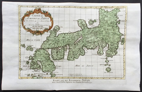
1752 Nicolas Bellin Original Antique Map The Islands of Japan - Empire du Japon
- Title : Carte De L'Empire Du Japon...1752
- Ref #: 61062
- Size: 16in x 10in (405mm x 255mm)
- Date : 1752
- Condition: (A+) Fine Condition
Description:
This beautifully hand coloured original antique map of Japan was engraved in 1752 by Jacques Nicolas Bellin - the date is engraved in the title cartouche - and was published in Antoine-François Prevost's monumental 20 volume edition ofL`Histoire Generale des Voyages published by Pierre de Hondt, The Hague between 1747 & 1780.
Background: Beautiful map showing the present day island of Kyushu named Isle de Ximo; the island of Shukoku named I. De Xixoco and the major island of Honshu named Isle de Nipon. The island contours are still speculative but harbors & towns, bays & offshore islands are noted, though their outlines and positions are still speculative and show the lack of accurate surveys brought back to Paris by navigators in the middle 18th century. (Ref: Tooley; M&B)
General Description:
Paper thickness and quality: - Heavy and stable
Paper color: - off white
Age of map color: - Early
Colors used: - Pink, green, yellow, red
General color appearance: - Authentic
Paper size: - 16in x 10in (405mm x 255mm)
Plate size: - 12 1/2in x 8 1/2in (320mm x 215mm)
Margins: - Min 1/2in (12mm)
Imperfections:
Margins: - None
Plate area: - Folds as issued
Verso: - None
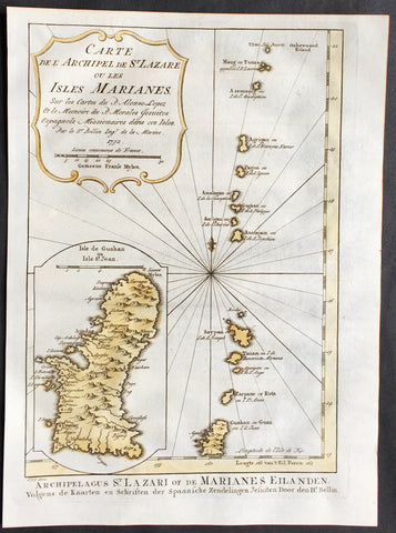
1752 Bellin Antique Map of The Marianas Islands & the Island of Guam
- Title : Carte De L Archipel de St Lazare ou les Isles Marianes...1752
- Ref #: 61066
- Size: 10in x 7 1/2in (255mm x 185mm)
- Date : 1752
- Condition: (A+) Fine Condition
Description:
This beautifully hand coloured originalantique map* of the Marianas Islands with a large inset map of Guam was engraved byJacques Nicolas Bellin in 1752 - the date is engraved in the title cartouche - for the 1756 French/Dutch edition of Antoine-François Prevosts L`Histoire Generale des Voyagespublished in 20 volumes by Pierre de Hondt in The Hague between 1747 & 1785.
The Mariana Islands (also the Marianas) are a crescent-shaped archipelago comprising the summits of fifteen mostly dormant volcanic mountains in the western North Pacific Ocean, between the 12th and 21st parallels north and along the 145th meridian east. They lie south-southeast of Japan, west-southwest of Hawaii, north of New Guinea and east of the Philippines, demarcating the Philippine Sea's eastern limit. They are found in the northern part of the western Oceanic sub-region of Micronesia, and are politically divided into two jurisdictions of the United States: the Commonwealth of the Northern Mariana Islands and, at the southern end of the chain, the territory of Guam.
The islands were named after Queen Mariana by Spaniards, who first arrived in the early 16th century and who eventually annexed and colonized the archipelago. The indigenous inhabitants are the Chamoru. Archaeologists in 2013 reported findings which indicated the people who first settled the Marianas arrived there after making what was at that time the longest uninterrupted ocean voyage in human history. They further reported findings which suggested that Tinian is likely to have been the first island in Oceania to have been settled by humans.
Antoine François Prévost d'Exiles 1697 - 1763, usually known simply as the Abbé Prévost, was a French author and novelist. (Ref: Tooley; M&B)
General Description:
Paper thickness and quality: - Heavy and stable
Paper color: - off white
Age of map color: - Early
Colors used: - Yellow, green, red, brown.
General color appearance: - Authentic and fresh
Paper size: - 10in x 7 1/2in (255mm x 190mm)
Plate size: - 9 1/2n x 7in (240mm x 180mm)
Margins: - Min ½in (12mm)
Imperfections:
Margins: - None
Plate area: - None
Verso: - None
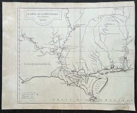
1752 D Anville Large Antique Map of Louisiana, New Orleans, Gulf Coast, America
- Title : Carte de La Louisiane Par le Sr D Anville Dressee Mai 1732. Publiee en 1752
- Ref #: 17025
- Size: 26in x 23in (710mm x 580mm)
- Date : 1752
- Condition: (A) Very Good Condition
Description:
This large original copper-plate engraved antique left sheet of the map of Louisiana and the Gulf Coast was first engraved in 1732 with updates to 1752 by Guillaume Nicolas Delahaye (1727 - 1802) - the dates are engraved in the title - and was published by Jean-Baptiste Bourguinon D Anville's in his large elephant folio atlas Atlas Generale.
NB - I have included an image of the map joined.
General Definitions:
Paper thickness and quality: - Heavy and stable
Paper color : - off white
Age of map color: -
Colors used: -
General color appearance: -
Paper size: - 26in x 23in (710mm x 580mm)
Plate size: - 24 3/4in x 20 3/4in (630mm x 530mm)
Margins: - Min 1/8in (3mm)
Imperfections:
Margins: - Light age toning and creasing in margins
Plate area: - Light age toning
Verso: - Small archival tape strips on verso
Background:
An uncommon, historically important and influential map of US South coast, stretching from the Gulf of Mobile to the mouth of the Sabine in Texas, centering on New Orleans and the surrounding area. It is one of the earliest and most detailed large format maps of the region, depicting early French settlements of the Gulf Coast region.
The map tracks the Mississippi, Arkansas, Red, Osage and Missouri Rivers.
It is known that Thomas Jefferson acquired 7 of D Anvilles maps in 1787, almost certainly, this was one of them. Jefferson commented to Gallatin about the importance of this map. Meriwether Lewis obtained a copy prior to the Lewis & Clark Expedition.
It is also know that most of the information for this map is derived from Valentin Devin, who arrived in Pensacola in 1719 and began producing highly detailed maps immediately upon his arrival on the Gulf Coast, until expelled by the Spanish after a three year struggle. Devin used his information and materials gathered from Le Maire and others to produce a number of manuscript maps which were sent back to France and resulted in a series of marvellous maps by De L'Isle, Buache and finally D'Anville, whose maps of the Gulf Coast formed the standard for a number of years.
To illustrate the cartography of the middle to latter part of the eighteenth century - especially detail of America & the Southern Hemisphere - a D' Anville map is essential. He dominated not only the French but all contemporary geographers, regardless of nationality.
He was foremost in using the latest and most accurate cartographic information from the latest discoveries of French explorers of the day but also from Cook and others. And unlike many cartographers of the day he was not adverse to leave blank spaces in his maps where knowledge was insufficient.
Please note all items auctioned are genuine, we do not sell reproductions. A Certificate of Authenticity (COA) can be issued on request.
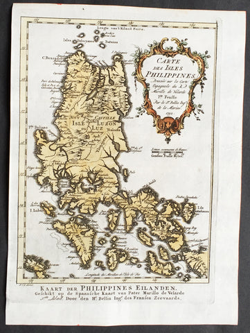
1752 Nicolas Bellin Original Antique Map of The Philippine Island of Luzon &....
- Title : Carte Des Isles Philippines...1752
- Ref #: 61065
- Size: 10in x 7 1/2in (255mm x 185mm)
- Date : 1752
- Condition: (A+) Fine Condition
Description:
This fine, original copper-plate engraved antique map of the main Philippine island of Luzon & the smaller southern islands by Jacques Nicolas Bellin in 1752 was published in Antoine François Prevosts 15 volumes of Histoire Generale des Voyages written by Prevost & other authors between 1746-1790.
Luzon was once split among Hindu-Buddhist kingdoms, Muslim principalities, and ethnoreligious tribes, who had trading connections with Borneo, Malaya, Java, Indochina, India, Okinawa, Korea, Japan and China before the Spanish established their rule. From just before the first millennium, the Tagalog and Kapampangan peoples of south and central Luzon had established several major coastal polities, most notable among them those of Maynila, Tondo and Namayan. The Laguna Copperplate Inscription, the first Philippine document written in 900AD, names places in and around Manila Bay as well as Medan in Indonesia. These kingdoms were based on leases between village rulers (Datu) and landlords (Lakan) or Rajahs, to whom tributes and taxes were levied. These kingdoms were coastal thalassocracies based on trade with neighboring Asian political entities at that time. Some parts of Luzon were Islamized when the Sultanate of Brunei expanded its realms from Borneo to the Philippines and set up the Kingdom of Maynila as its puppet-state. In addition, other kingdoms like the Wangdom of Pangasinan had become tributary states to China and were largely Sinified kingdoms.
According to sources at the time, the trade in large native Ruson-tsukuri clay jars used for storing green tea and rice wine with Japan flourished in the 12th century, and local Tagalog, Kapampangan and Pangasinense potters had marked each jar with Baybayin letters denoting the particular urn used and the kiln the jars were manufactured in. Certain kilns were renowned over others and prices depended on the reputation of the kiln. Of this flourishing trade, the Burnay jars of Ilocos are the only large clay jar manufactured in Luzon today with origins from this time.
The Yongle Emperor instituted a Chinese Governor on Luzon during Zheng He\'s voyages and appointed Ko Ch\'a-lao to that position in 1405. China also had vassals among the leaders in the archipelago. China attained ascendancy in trade with the area in Yongle\'s reign.
In the 1500s, people from Luzon were called Lucoes and were actively employed in trading, seafaring and military campaigns across Southeast Asia.
The Portuguese were the first European explorers who recorded it in their charts as Luçonia or Luçon and inhabitants were called Luçoes.[16] Edmund Roberts, who visited Luzon in the early 19th century, wrote that Luzon was \"discovered\" in 1521. Many people from Luzon had active-employment in Portuguese Malacca. Lucoes such as the Luzon spice trader Regimo de Raja, based in Malacca, was highly influential and the Portuguese appointed him as Temenggong (Sea Lord) or a governor and police-chief general responsible for overseeing of maritime trade, at Malacca. His father and wife carried on his maritime trading business after his death. Another important Malacca trader was Curia de Raja who also hailed from Luzon. The \"surname\" of \"de Raja\" or \"diraja\" could indicate that Regimo and Curia, and their families, were of noble or royal descent as the term is an abbreviation of Sanskrit adiraja.
Pinto noted that there were a number of Lucoes in the Islamic fleets that went to battle with the Portuguese in the Philippines during the 16th century. The Sultan of Aceh gave one of them (Sapetu Diraja) the task of holding Aru (northeast Sumatra) in 1540. Pinto also says one was named leader of the Malays remaining in the Moluccas Islands after the Portuguese conquest in 1511. Pigafetta notes that one of them was in command of the Brunei fleet in 1521.
However, the Luções did not only fight on the side of the Muslims. Pinto says they were also apparently among the natives of the Philippines who fought the Muslims in 1538.
On Mainland Southeast Asia, Lusung/Lucoes warriors aided the Burmese king in his invasion of Siam in 1547 AD. At the same time, Lusung warriors fought alongside the Siamese king and faced the same elephant army of the Burmese king in the defence of the Siamese capital at Ayuthaya.
Scholars have thus suggested that they could be mercenaries valued by all sides.
The Spanish arrival in the 16th century saw the incorporation of the Lucoes people and the breaking up of their kingdoms and the establishment of the Las Islas Filipinas with its capital Cebu, which was moved to Manila following the defeat of the local Rajah Sulayman in 1570. Under Spain, Luzon also came to be known as the Nueva Castilla or the New Castile.
General Definitions:
Paper thickness and quality: - Heavy and stable
Paper color : - off white
Age of map color: - Early
Colors used: - Green, Yellow,
General color appearance: - Authentic
Paper size: - 10in x 7 1/2in (255mm x 185mm)
Plate size: - 9 1/2in x 6 1/2in (245mm x 165mm)
Margins: - Min 1/2in (6mm)
Imperfections:
Margins: - None
Plate area: - None
Verso: - None
Background:
One of Antoine Francois Prevosts monumental undertakings was his history of exploration & discovery in 15 volumes titledHistoire Générale des Voyages written between 1746-1759 and was extended to 20 volumes after his death by various authors.
The 20 volumes cover the early explorations & discoveries on 3 continents: Africa (v. 1-5), Asia (v. 5-11), and America (v. 12-15) with material on the finding of the French, English, Dutch, and Portugese.
A number of notable cartographers and engravers contributed to the copper plate maps and views to the 20 volumes including Nicolas Bellin, Jan Schley, Chedel, Franc Aveline, Fessard, and many others.
The African volumes cover primarily coastal countries of West, Southern, and Eastern Africa, plus the Congo, Madagascar, Arabia and the Persian Gulf areas.
The Asian volumes cover China, Korea, Tibet, Japan, Philippines, and countries bordering the Indian Ocean.
Volume 11 includes Australia and Antarctica.
Volumes 12-15 cover voyages and discoveries in America, including the East Indies, South, Central and North America.
Volumes 16-20 include supplement volumes & tables along with continuation of voyages and discoveries in Russia, Northern Europe, America, Asia & Australia.
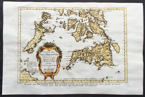
1752 Bellin Original Antique Map Islands of the Southern Philippines - Mindanao
- Title : Carte Des Isles Philippines...1752
- Ref #: 61064
- Size: 15in x 10in (380mm x 255mm)
- Date : 1752
- Condition: (A+) Fine Condition
Description:
This beautifully hand coloured original antique map of the Southern Philippines was engraved in 1752 - dated in title cartouche - by Jacques Nicolas Bellin for the 1756 French/Dutch edition of Antoine-François Prevosts L`Histoire Generale des Voyages printed in 20 volumes by Pierre de Hondt, The Hague between 1747 & 1785. (Ref: Tooley; M&B)
General Condition:
Paper thickness and quality: - Heavy and stable
Paper color: - off white
Age of map color: - Early
Colors used: - Red, green, yellow
General color appearance: - Authentic
Paper size: - 15in x 10in (380mm x 255mm)
Plate size: - 12 1/2in x 9in (320mm x 230mm)
Margins: - Min 1/2in (12mm)
Imperfections:
Margins: - None
Plate area: - Folds as issued
Verso: - None
Background:
One of Antoine Francois Prevosts monumental undertakings was his history of exploration & discovery in 15 volumes titledHistoire Générale des Voyages written between 1746-1759 and was extended to 20 volumes after his death by various authors.
The 20 volumes cover the early explorations & discoveries on 3 continents: Africa (v. 1-5), Asia (v. 5-11), and America (v. 12-15) with material on the finding of the French, English, Dutch, and Portugese.
A number of notable cartographers and engravers contributed to the copper plate maps and views to the 20 volumes including Nicolas Bellin, Jan Schley, Chedel, Franc Aveline, Fessard, and many others.
The African volumes cover primarily coastal countries of West, Southern, and Eastern Africa, plus the Congo, Madagascar, Arabia and the Persian Gulf areas.
The Asian volumes cover China, Korea, Tibet, Japan, Philippines, and countries bordering the Indian Ocean.
Volume 11 includes Australia and Antarctica.
Volumes 12-15 cover voyages and discoveries in America, including the East Indies, South, Central and North America.
Volumes 16-20 include supplement volumes & tables along with continuation of voyages and discoveries in Russia, Northern Europe, America, Asia & Australia.
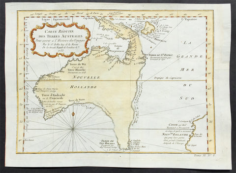
1753 Bellin Antique Map of Australia & New Zealand - Carte Reduite.....Australes
- Title : Carte Reduite des Terres Australes pour Servir a l'Histoire des Voyages...1753
- Ref #: 61042
- Size: 12 1/2in x 9 1/4in (320mm x 230mm)
- Date : 1753
- Condition: (A+) Fine Condition
Description:
This beautifully hand coloured original antique map* of Australia - one of the earliest near complete maps dedicated to the Island Continent - was engraved in 1753 by Jacques Nicolas Bellin - date engraved in the title -and was published by Antoine Prevost in Histoire Generale Des Voyages.
Background: This is one of the few 18th century maps to focus on the Australian continent prior to Cook's famous first voyage from 1768-1771. Mainland Australia is connected to both Tasmania (Terre de Van Diemen) and Papua New Guinea (Nouv. Guinee). Along the imaginary eastern coastline is a note that reads: "I suppose that the land of Diemen can join with the land of the Holy Ghost, but this is without proof." A partial coastline of New Zealand is shown peeking out of the corner of the map, with a note that it was discovered by Abel Tasman in 1642 and speculation that it might be part of a great southern continent. This is an important map of Australia depicting the interesting theories made prior to exploration of the region later in the 18th century. (Ref: Tooley; M&B)
General Description:
Paper thickness and quality: - Heavy and stable
Paper color: - off white
Age of map color: - Early
Colors used: - Yellow, green, red, brown.
General color appearance: - Authentic and fresh
Paper size: - 12 1/2in x 9 1/4in (320mm x 230mm)
Plate size: - 11 3/4n x 8 1/2in (295mm x 215mm)
Margins: - Min ½in (12mm)
Imperfections:
Margins: - None
Plate area: - Folds as issued
Verso: - None
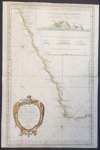
1754 Bellin Large Old, Antique Map of Southern Africa, inset view of Cape Town
- Title : Carte Reduite D Une Partie Des Costes Occidentalies et Meridionales De L Afrique...MDCCLIV
- Ref #: 50656
- Size: 35 1/2in x 25in (900mm x 510mm)
- Date : 1754
- Condition: (A+) Fine Condition
Description:
This very large finely engraved beautifully hand coloured original antique map, sea chart, of SW Coast of Africa - with an inset view of Cape Town - by Jacques Nicolas Bellin in 1754 - dated in the title cartouche.
Background: This is a scarce and attractive nautical chart depicting the southwest coast of Africa from Cape Fria in Namibia to Cape Agulhas (Cape of the Needles) and the Bay of St. Blaise, including the Cape of Good Hope.
It shows incredible detail along the coast with capes, bays and topographical features including mountains, rivers as well as coastal features noted. Elevation is beautifully rendered in profile.
The map includes three profile views in the top right quadrant. These are ‘Vue Du Cap de Bonne Esperance’ (Cape of Good Hope), ‘Vue Du Cap Falso, Du Cap Des Eguilles et des Terres Qui sont Entre deux’ and ‘Autre Vue Du Cap Falso et Du Cap Des Eguilles’. Cape Town, Constance (Constantia), Stellenbosch and Hangklip are accurately identified
Being part of the Mediterranean world, the northern coasts of the African continent as far as the Straits of Gibraltar and even round to the area of the Fortunate Isles (the Canaries) were reasonably well known and quite accurately mapped from ancient times. In particular, Egypt and the Nile Valley were well defined and the Nile itself was, of course, one of the rivers separating the continents in medieval T-O maps. Through Arab traders the shape of the east coast, down the Red Sea as far as the equator, was also known but detail shown in the interior faded into deserts with occasional mountain ranges and mythical rivers. The southern part of the continent, in the Ptolemaic tradition, was assumed to curve to the east to form a land-locked Indian Ocean. The voyages of the Portuguese, organized by Henry the Navigator in the fifteenth century, completely changed the picture and by the end of the century Vasco da Gama had rounded the Cape enabling cartographers to draw a quite presentable coastal outline of the whole continent, even if the interior was to remain largely unknown for the next two or three centuries.
The first separately printed map of Africa (as with the other known continents) appeared in Munster's Geographia from 1540 onwards and the first atlas devoted to Africa only was published in 1588 in Venice by Livio Sanuto, but the finest individual map of the century was that engraved on 8 sheets by Gastaldi, published in Venice in 1564. Apart from maps in sixteenth-century atlases generally there were also magnificent marine maps of 1596 by Jan van Linschoten (engraved by van Langrens) of the southern half of the continent with highly imaginative and decorative detail in the interior. In the next century there were many attractive maps including those of Mercator/Hondius (1606), Speed (1627), Blaeu (1 630), Visscher (1636), de Wit (c. 1670), all embellished with vignettes of harbours and principal towns and bordered with elaborate and colourful figures of their inhabitants, but the interior remained uncharted with the exception of that part of the continent known as Ethiopia, the name which was applied to a wide area including present-day Abyssinia. Here the legends of Prester John lingered on and, as so often happened in other remote parts of the world, the only certain knowledge of the region was provided by Jesuit missionaries. Among these was Father Geronimo Lobo (1595-1678), whose workA Voyage to Abyssinia was used as the basis for a remarkably accurate map published by a German scholar, Hiob Ludolf in 1683. Despite the formidable problems which faced them, the French cartographers G. Delisle (c. 1700-22), J. B. B. d'Anville (1727-49) and N. Bellin (1754) greatly improved the standards of mapping of the continent, improvements which were usually, although not always, maintained by Homann, Seutter, de Ia Rochette, Bowen, Faden and many others in the later years of the century. (Ref: Tooley; M&B)
General Description:
Paper thickness and quality: - Heavy and stable
Paper color: - Blue
Age of map color: - Early
Colors used: - Yellow, green pink, blue
General color appearance: - Authentic
Paper size: - 35 1/2in x 25in (900mm x 510mm)
Plate size: - 35in x 23in (890mm x 595mm)
Margins: - Min 1/2in (12mm)
Imperfections:
Margins: - None
Plate area: - Creasing along centerfold
Verso: - None

1754 Milton, Cleveley, Canot Antique Plan View Portsmouth Dockyards, HMS Victory
- Title : A Geometrical Plan West Elevation of His Majestys Dock Yard Near Portsmouth with part of the Common...Thomas Milton Surv...Published according to the Act of Parliament April 29th 1754.
- Size: 26in x 19 1/2in (660mm x 495mm)
- Condition: (C) Fair Condition
- Date : 1754
- Ref #: 93115
Description:
This large original hand coloured copper plate engraved antique plan and view of His Majestys Dockyard Plymouth by the artist John Cleveley was engraved by the French engraver Pierre Charles Canot and published as one of six engravings in Thomas Milton\'s Royal Dockyards in 1754 - dated.
The plan/view has had some previous damage with the bottom left section 9in x 4in restored with loss to bottom corner, as well as a small section of the cartouche and margins. The plan has been mounted on contemporary heavy paper. Still a very nice piece despite the restoration.
The plan of the dockyards would have been undertaken by Canot whereas the views of the ship-yard is by John Cleveley the Elder. Several ships engraved around the decorative border including a listing HMS Victory at the top.
General Definitions:
Paper thickness and quality: - Heavy and stable
Paper color : - off white
Age of map color: - Original
Colors used: - Yellow, green, blue, pink
General color appearance: - Authentic
Paper size: - 26in x 19 1/2in (660mm x 495mm)
Plate size: - 26in x 19 1/2in (660mm x 495mm)
Margins: - Min 1/2in (10mm)
Imperfections:
Margins: - Bottom corner loss, small loss top right margin
Plate area: - Restoration left section 9in x 4in and small section of cartouche
Verso: - Mounted on contemporary heavy paper
Background:
One of a series of views of the six Royal Dockyards, which were by the mid-eighteenth century the world\'s largest industrial complex and the state\'s biggest investment. These engravings present the dockyards as orderly, efficient, and rational; each makes reference to the specific functions of the dockyard represented, which depended in part on location. When France replaced Holland as Britain\'s major rival in the late seventeenth century, Plymouth and Portsmouth became the more strategically significant yards, serving as naval bases and fleet rendezvous for campaigns in the Atlantic and the Channel respectively. Chatham, Plymouth and Portsmouth, where the fleets moored during the winter or while on reserve, became employed more in repairs than ship building. The cartouche on the left side of this print describes the content of the vignettes bordering the primary image. It is inscribed as follows: References to Eight of the Twelve Capital Ships taken from the French the 3rd of May and 17th of October 1747 as Drawn in the Border. Thus, rather than illustrating scenes in a ships “biography” (as is typical for other prints in this series), the ships shown in the vignettes bordering this print serve as a record of the activities of the dockyard at a particular moment.
Pierre-Charles Canot .1710–77 was a French engraver who spent most of his career in England.
Canot was born in France in about 1710. In 1740 he moved to England, where he lived there the rest of his life. He was elected an Associate Engraver of the Royal Academy in 1770, and died at Kentish Town, then just outside London, in 1777. He engraved a large number of landscapes, sea-pieces, and other subjects after artists including Jan van Goyen, Lorrain and Jean Pillement. Joseph Strutt believed that his best prints were some large plates of maritime subjects after the works of Richard Paton.
Cleveley, John 1712 - 1777
John Cleveley the Elder was an English marine artist. and was born in Southwark. He was not from an artistic background, and his father intended him to follow the family trade of joinery, so he set up as a carpenter or shipwright in around 1742 at the Deptford Dockyard. Continuing his work in that area throughout his life (indeed, he is referred to as ‘carpenter belonging to His Majesty’s Ship Victory, in the pay of His Majestys Navy’ in letters of administration granted by the Admiralty in 1778 to his widow, probably when she was first fitting out), from about 1745 he also worked as a painter, mostly ship portraits, dockyard scenes of shipbuilding and launches, and some other marine views. They combined his knowledge of shipbuilding with accurate architectural and topographical detail. Apparently mostly self-taught, it is possible that dockyard ship-painters also gave him some training in this area. He toured East Anglia, and produced some paintings from notes made on that trip.

1754 Thomas Jefferys Old, Antique Map of Europe - Large Poland
- Title : Europe T Jefferys Sc.
- Ref : 11-1804
- Size: 10in x 8in (255mm x 205mm)
- Date : 1754
- Condition: (A+) Fine Condition
Description:
This beautifully hand coloured original antique map of Europe by Thomas Jeffery's was published in 1754. (Ref: Tooley; M&B)
General Description:
Paper thickness and quality: - Heavy and stable
Paper color: - off white
Age of map color: - Early
Colors used: - Yellow, green, pink
General color appearance: - Good
Paper size: - 10in x 8in (255mm x 205mm)
Plate size: - 9 1/2in x 7 1/2in (240mm x 190mm)
Margins: - Min 1/4in (5mm)
Imperfections:
Margins: - None
Plate area: - Folds as issued
Verso: - None

1754 Thomas Jefferys Old, Antique Map of South America
- Title : South America
- Ref : 11-1964
- Size: 10in x 8in (255mm x 205mm)
- Date : 1754
- Condition: (A+) Fine Condition
Description:
This beautifully hand coloured original antique map of South America by Thomas Jeffery's was published in 1754. (Ref: Tooley; M&B)
General Description:
Paper thickness and quality: - Heavy and stable
Paper color: - off white
Age of map color: - Early
Colors used: - Yellow, green, pink
General color appearance: - Good
Paper size: - 10in x 8in (255mm x 205mm)
Plate size: - 9 1/2in x 7 1/2in (240mm x 190mm)
Margins: - Min 1/4in (5mm)
Imperfections:
Margins: - None
Plate area: - Folds as issued
Verso: - None
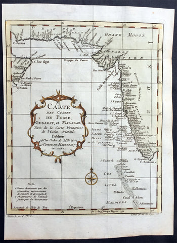
1755 Bellin Antique Coastal Map of Western India, Pakistan, Iran & Saudi Arabia
- Title : Carte des Costes de Perse, Gusarat, et Malabar...1740
- Date : 1740
- Size: 12in x 9in (305mm x 230mm)
- Ref #: 60905
- Condition: (A+) Fine Condition
Description:
This beautifully hand coloured original antique map of the coastal regions of the western Indian Coast to The Persian Gulf & Saudi Arabia was engraved in 1740 - dated in title cartouche - by Jacques Nicolas Bellin for the 1756 French edition of Antoine-François Prevosts L`Histoire Generale des Voyages printed in 20 volumes by Pierre de Hondt, The Hague between 1747 & 1785. (Ref: Tooley; M&B)
General Condition:
Paper thickness and quality: - Heavy and stable
Paper color: - off white
Age of map color: - Early
Colors used: - Red, green, yellow
General color appearance: - Authentic
Paper size: - 12in x 9in (305mm x 230mm)
Plate size: - 10in x 8 1/2in (255mm x 215mm)
Margins: - Min 1/2in (12mm)
Imperfections:
Margins: - None
Plate area: - Folds as issued
Verso: - None
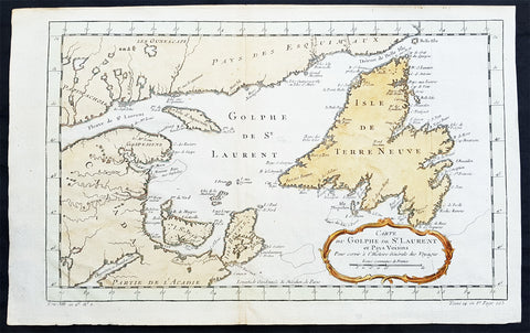
1755 Bellin Original Antique Map of Gulf of St Lawrence & Newfoundland, Canada
- Title : Carte Du Golphe de St Laurent et pay Voisins
- Ref #: 60047
- Size: 16in x 10in (410mm x 255mm)
- Date : 1755
- Condition: (A+) Fine Condition
Description:
This beautifully hand coloured original antique map of The Gulf of St Lawrence River and Newfoundland by Jacques Nicolas Bellin in 1755 was published by Antoine-François Prevosts in 1755 for the 20 volume edition of L`Histoire Generale des Voyages published by Pierre de Hondt, The Hague between 1747 & 1785. (Ref: Tooley; M&B)
General Description:
Paper thickness and quality: - Light and stable
Paper color: - off white
Age of map color: - Early
Colors used: - Red, green, yellow
General color appearance: - Authentic
Paper size: - 16in x 10in (410mm x 255mm)
Plate size: - 15in x 9 1/2in (345mm x 295mm)
Margins: - Min 1/2in (10mm)
Imperfections:
Margins: - None
Plate area: - Folds as issued
Verso: - None
1755 Prevost & Schley Antique City Map of Hangzhou in Zhejiang Province, China
- Title: Plan De la Ville de Hang-Tcheou-Fou ou Hang chew Fu Capitale de la Province de Che-Kiang
- Date: 1755
- Size: 10in x 8in (255mm x 205mm)
- Ref: 34168
- Condition : (A+) Fine Condition
Description:
This fine, original copper-plate engraved antique map a plan of the city of Hangzhou (here Hang Chew Fu) in the Zhejiang province of China by Jakob van Schley in 1755 - after Jean-Baptiste Du Halde - was published in Antoine François Prevosts 15 volumes of Histoire Generale des Voyages written by Prevost & other authors between 1746-1789.
Jean-Baptiste Du Halde, born in Paris on 1 February 1674 and died 18 August 1743, was a French Jesuit historian specializing in China. He did not travel to China, but collected seventeen Jesuit missionaries\\\' reports and provided an encyclopedic survey of the history, culture and society of China and Chinese Tartary, that is, Manchuria.
General Definitions:
Paper thickness and quality: - Heavy and stable
Paper color : - off white
Age of map color: - Original
Colors used: - Yellow, green, blue, pink
General color appearance: - Authentic
Paper size: - 10in x 7 1/2in (255mm x 190mm)
Plate size: - 10in x 7 1/2in (255mm x 190mm)
Margins: - Min 1/2in (12mm)
Imperfections:
Margins: - None
Plate area: - None
Verso: - None
Background:
Hangzhou romanization Hang-chou, conventional Hangchow, city and capital of Zhejiang sheng (province), China. The city is located in the northern part of the province on the north bank of the Qiantang River estuary at the head of Hangzhou Bay. It has water communications with the interior of Zhejiang to the south, is the southern terminus of the Grand Canal, and is linked to the network of canals and waterways that cover the Yangtze River (Chang Jiang) delta area to the north. The city stands at the eastern foot of a scenic range of hills, the Tianmu (“Eye of Heaven”) Mountains, and on the shore of the famous Xi (West) Lake, celebrated in poetry and paintings for its beauty and a favourite imperial retreat.
The county of Qiantang was first established at this site under the Qin dynasty (221–207 BCE) but did not start developing until the 4th and 5th centuries CE, when the Yangtze River delta area began to be settled. A prefecture named Hangzhou was created there in 589, during the Sui dynasty (581–618), which is the source of the city’s name. It became a major local centre with the completion of the Jiangnan Canal (then the southern section of the Grand Canal) in 609. During the Ten Kingdoms (Shiguo) period (907–960), Hangzhou was the capital of the state of Wu-Yue. In the later Song period (960–1279), northern China fell to the Jin (Juchen) dynasty (1115–1234); from 1127 the Song rulers were confined to southern China, and they made Hangzhou (then known as Lin’an) their capital. A centre of commerce, it was visited in the late 13th century by the Venetian traveler Marco Polo, who called it Kinsai, or Quinsay; it then had an estimated population of 1 million to 1.5 million.
Although it never again reached the peak of importance that it had achieved as capital of the Nan (Southern) Song, Hangzhou remained important. Under the Ming (1368–1644) and Qing (1644–1911/12) dynasties, it was a superior prefecture, in addition to being the provincial capital of Zhejiang. It became immensely wealthy, being at the centre of a fertile rice-growing area as well as being the site of the most important silk industries in China. It also was famous as a centre of culture, producing numerous writers, painters, and poets. Its importance as a port dwindled, however, as Hangzhou Bay gradually silted up and as its outport, Ganpu, became useless. From the 14th century its trade gradually shifted to Ningbo to the southeast on the southern shore of the bay and, in the 19th century, to the new city of Shanghai, some 100 miles (160 km) to the northeast at the mouth of the Yangtze. In 1861, during the Taiping Rebellion (1850–64), the city fell to the rebels and suffered severe damage.
1755 Bellin Antique Map Western Mali, Senegal and Niger Rivers in West Africa
- Title : Carte Du Cours des Rivieres de Faleme et Sanaga Dans le Pays de Bambuc et Tamba Awra
- Size: 13 1/2in x 12in (345mm x 305mm)
- Ref #: 15989
- Date : 1757
- Condition: (A) Very Good Condition
Description:
This fine original copper-plate engraved antique map of Western Mali showing the divergence of the Senegal and Niger rivers in West Africa by Jacques Nicolas Bellin was published in 1755 in Antoine François Prevosts 15 volumes of Histoire Generale des Voyageswritten by Prevost & other authors between 1746-1790.
General Definitions:
Paper thickness and quality: - Heavy and stable
Paper color : - off white
Age of map color: -
Colors used: -
General color appearance: -
Paper size: - 13 1/2in x 12in (345mm x 305mm)
Plate size: - 12in x 11 1/2in (305mm x 295mm)
Margins: - Min 1/2in (12mm)
Imperfections:
Margins: - None
Plate area: - Folds as issued
Verso: - None
Background:
One of Antoine Francois Prevosts monumental undertakings was his history of exploration & discovery in 15 volumes titledHistoire Générale des Voyages written between 1746-1759 and was extended to 20 volumes after his death by various authors.
The 20 volumes cover the early explorations & discoveries on 3 continents: Africa (v. 1-5), Asia (v. 5-11), and America (v. 12-15) with material on the finding of the French, English, Dutch, and Portugese.
A number of notable cartographers and engravers contributed to the copper plate maps and views to the 20 volumes including Nicolas Bellin, Jan Schley, Chedel, Franc Aveline, Fessard, and many others.
The African volumes cover primarily coastal countries of West, Southern, and Eastern Africa, plus the Congo, Madagascar, Arabia and the Persian Gulf areas.
The Asian volumes cover China, Korea, Tibet, Japan, Philippines, and countries bordering the Indian Ocean.
Volume 11 includes Australia and Antarctica.
Volumes 12-15 cover voyages and discoveries in America, including the East Indies, South, Central and North America.
Volumes 16-20 include supplement volumes & tables along with continuation of voyages and discoveries in Russia, Northern Europe, America, Asia & Australia.
1755 Bellin & Homann Large Old, Antique Map of Canada & New England
- Title : Partie Orientale de la Nouvelle France ou du Canada - 1755
- Ref #: 50678
- Size: 24in x 21in (610mm x 535mm)
- Date : 1755
- Condition: (A+) Fine Condition
Description:
This large beautifully hand coloured original antique map of Eastern Canada & New England to Cape Cod was engraved in 1755 by Jacques Nicolas Bellin - the date is engraved in the title cartouche - and published by the re-known German publishers Homann Heirs.
Background: This is Bellin's definitive map of eastern Canada and New England showing the mouth of the St. Lawrence, the length of the river, the Maritime provinces and French claims in the region. There are some very interesting details of the coastal towns, showing Havre de Baston for Boston Harbor, up the coast to Portsmouth in New Hampshire, Wells, York and Cape Elizabeth in Maine. There is considerable information shown on the extent of French exploration in the region. Large decorative cartouche incorporates two distance scales. This example is from the second plate with the imprint "A Paris chez R.J. Julien a l'Hotel…" removed, the date changed and various geographical improvements. Blank verso. This large format Bellin map was published in several atlases by Homann. (Ref: Tooley; M&B)
General Description:
Paper thickness and quality: - Heavy and stable
Paper color: - Blue
Age of map color: - Early
Colors used: - Yellow, green pink, blue
General color appearance: - Authentic
Paper size: - 24in x 21in (610mm x 535mm)
Plate size: - 22in x 18in (560mm x 460mm)
Margins: - Min 1in (25mm)
Imperfections:
Margins: - None
Plate area: - Old red ink penned in several places on map
Verso: - Bottom centerfold re-joined, no loss
1755 D Anville Large Old, Antique Map of North America, Great Lakes, Indian Wars
- Title : Canada Louisiane et Terres Anglois Par Le Sr. D Anville...MDCCLV
- Ref #: 61106
- Size: 46 1/2in x 35 3/4in (1.17m x 910mm)
- Date : 1755
- Condition: (A+) Fine Condition
Description:
This magnificent, scarce, very large (48in x 35in) & highly detail map of North America was engraved in 1755 - dated in the title cartouche - by George De La Haye and was published by Jean Baptiste Bourguignon D'Anville in his large elephant folio atlas Atlas Generale.
Geopolitically this map is extremely significant drawn as war between the Global Powers of the day, France, England & Spain, was breaking, known in Europe as the Seven Year War known in North America as the French & Indian war. (Please see below for more detail)
This map rivals John Mitchells "A Map of the British and French Dominions in North America published in 1755" - considered to be one of the most significant maps of North America published in the 18th & 19th centuries (a 1st edition of Mitchells map is currently for sale for $165,000).
I have included an image of the Mitchell map for comparison. The D' Anville map is considered by many to be cartographically superior to the Mitchell map, at a fraction of the price.
Background: This extraordinary map of the eastern half of North America extends from Newfoundland, Canada to St. Augustine, Florida, stretching westward beyond the Mississippi as far as modern day Texas. The map includes both the original colonial colonies along the Atlantic seaboard from Maine to Georgia and the French claims in Louisiana (the Mississippi Valley) and modern day Canada. Florida is acknowledged as a Spanish enclave. Elevation is rendered in profile with fortifications, towns, and American Indian villages identified. A large inset map centres on the course of the St. Lawrence River from the Isle Aux Coudres to Lake Ontario.
The is a very significant map, drawn from a definitive French perspective, defining the territorial alignments and claims within North America shortly following the outbreak of the French and Indian War, considered to be a New World reflection of the European Seven Years War. It is however notable that it began before the larger hostilities in Europe and most of the major battles involved primarily parties only loosely aligned with the French or English - most specifically American Indians and lawless frontiersman, who had their own political agenda.
The war began with French incursions into western Pennsylvania and other territories claimed simultaneously by the French, English and American Indian forces. Just prior to the war, the French, in the interest of broadening their hold on the lucrative fur trade, established a series of forts, all of which are here noted, along the length of the Mississippi and further east, including Fort Duquesne (here Fort de Quene, Pittsburgh), Fort de la Presquisle, and for Le Beouf (here, Fort de la Riv Jaus Beufs).
The map also recognizes British claims, only inland as far as the Appalachian Mountains, beyond which place names take on a noticeably French character. These last three forts occupied particularly contested territory under the control of the powerful British allied Iroquois League. The most contested of these was Fort Duquesne (modern day Pittsburgh) in direct opposition to another fort then being constructed by the Ohio Company, a trading and land speculation firm established by prominent Virginia colonials, including George Washington. The Virginian colonial governor responded to Duquesne by sending then Lieutenant George Washington and a band of Virginia militiamen to harass the French. The resulting Jumonville Affair, in which Washington oversaw an attack on a French Canadian diplomatic forces led by Joseph Coulon de Villiers de Jumonville, to warn the Ohio Company fort builders away from French claimed territory. The slaying of Jumonville and several other French diplomats prompted a response from French forces at Fort Duquesne, leading to Washington's retreat and construction of Fort Necessity, really little more than a palisaded shack, marked here just south of Fort Duquesne. These events, all of which occurred in May of 1754, were said to have increased hostilities in Europe and led to the start of the Seven Year War in 1755.
Beyond the political agenda of this map, is the map itself, being one of the finest and most heavily detailed maps of North America published in the mid 18th century. Ranking alongside the large 1755 Mitchell map in detail but judged by many as cartographically superior. Drawing on both French and British cartographical detail, D' Anville identifies countless American Indian tribes, many of which, like the Sioux and Missouri, the British had only vague knowledge. Moreover, he also includes detail such as swamps, rapids, fords, abandoned villages, and even the ancient remnants of mound builder culture in the Ohio Valley. D' Anville notably does not include Mitchell's fictional Lake Superior islands.
This map was originally published to accompany the pamphlet entitledMemoire sur la carte intitulee: Canada, Louisiane, & Terres angloises and was also published in four parts for D' Anville's Atlas General.
These large maps are hard to find in such good condition and make fantastic historical reference tools due to the size and high level of detail as with all D' Anvilles work. (Ref: Tooley, M&B)
General Description:
Paper thickness and quality: - Heavy and stable
Paper color: - White
Age of map color: - Original & late
Colors used: - Yellow, green, pink
General color appearance: - Authentic
Paper size: - 46 1/2in x 35 3/4in (1.17m x 910mm)
Plate size: - 45in x 35in (1.12m x 890mm)
Margins: - Min 1in (25mm)
Imperfections:
Margins: - None
Plate area: - Light soiling & ceasing along folds
Verso: - Light soiling