Europe (376)
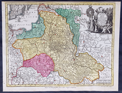
1744 Georg Mattaus Seutter Antique Map of Poland, Lithuania & Baltic Countries
- Title : Polonia Regnum ul et Magni Ducat Lithuania........a Matth. Seutteri...T C Lotter, Geogr.
- Ref #: 93400
- Size: 11in x 8 1/2in (280mm x 215mm)
- Date : 1744
- Condition: (A+) Fine Condition
Description:
This beautifully hand coloured original copper-plate engraved antique map of Poland, Lithuania & the Baltic Countries was engraved by Tobias Lotter and was published in the 1744 edition of GM Seutters Atlas Minor Prae cipua Orbis Terrarum Imperia Regna et Provincias...., Augsburg, Germany.
General Definitions:
Paper thickness and quality: - Heavy and stable
Paper color : - off white
Age of map color: - Original
Colors used: - Yellow, green, blue, pink
General color appearance: - Authentic
Paper size: - 11in x 8 1/2in (280mm x 215mm)
Plate size: - 10 1/2in x 8in (265mm x 205mm)
Margins: - Min 1/4in (5mm)
Imperfections:
Margins: - None
Plate area: - None
Verso: - None
Background:
Atlas Minor was a series of beautiful maps of all parts of the world. Georg Matthäus Seutter was one of the most and important of the German cartographers of the 18th century, being appointed as the Geographer to the Imperial Court. His son, Albrecht Carl, joined Matthäus and eventually inherited the business. The maps from Atlas Minor were drawn by the two Seutters and engraved by Tobias Conrad Lotte. These maps are highly detailed and engraved with a bold hand with equally strong original hand color in the body of the map as was the 18th century German style. The cartouches were left uncolored in order to emphasize the elaborately detailed illustrations for which German maps are especially prized. These are some of the most decorative and interesting maps of the eighteenth century.
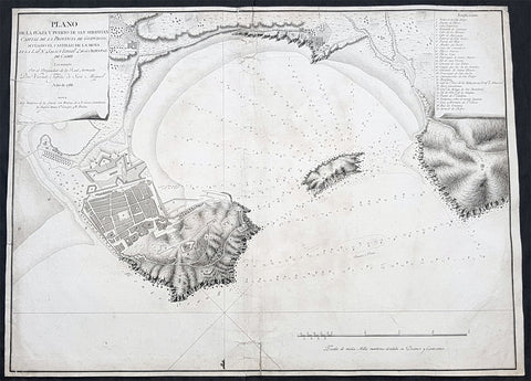
1788 Vicente Tofino Large Antique Map of San Sebastian & La Concha, Basque Spain
- Title : Plano de la plaza y puerto de San Sebastian Capital de la Provincia de Guipuzcoa, situado el castillo de la Mota en... Ano 1788
- Size: 23 1/2in x 17in (595mm x 435mm)
- Condition: (B) Good Condition
- Date : 1788
- Ref #: 80774
Description:
This large original copper plate engraved scarce antique map of the city of San Sebastian and the Bay of La Concha on the northern Basque coast of Spain by the Spanish navigator and cosmographer Vincente Tofiño de San Miguel was engraved in 1788 - dated - and was published in Tofinos 1789 edition of Derrotero de las costas de España en el Océano Atlántico y de las islas Azores o Terceras, para inteligencia y uso de las cartas esféricas (Pilots Log-book of the Coasts of Spain in the Atlantic Ocean and of the Azores, for the use of naval intelligence and nautical charts).
General Definitions:
Paper thickness and quality: - Heavy and stable
Paper color : - off white
Age of map color: -
Colors used: -
General color appearance: -
Paper size: - 23 1/2in x 17in (595mm x 435mm)
Plate size: - 23 1/2in x 17in (595mm x 435mm)
Margins: - Min 1/4in (5mm)
Imperfections:
Margins: - 5 small repairs to margins going into image
Plate area: - Soiling, small separation of bottom centerfold
Verso: - Soiling
Background:
San Sebastián is a coastal city and municipality located in the Basque Autonomous Community, Spain
After a long period of silence in evidence, in 1014 the monastery of St. Sebastián with its apple orchards (for cider), located in the term of Hernani, is donated to the Abbey of Leire by Sancho III of Pamplona. By 1181, the city is chartered (given fuero) by king Sancho VI of Pamplona on the site of Izurum, having jurisdiction over all the territory between the rivers Oria and Bidasoa.
In 1200, the city was conquered by Castile, whose king Alfonso VIII, confirmed its charter (fuero), but the Kingdom of Navarre was deprived of its main direct access out to the sea. Perhaps as soon as 1204 (or earlier), the city nucleus at the foot of Urgull started to be populated with Gascon-speaking colonizers from Bayonne and beyond, who left an important imprint in the citys identity in the centuries to come.
In 1265, the use of the city as a seaport is granted to Navarre as part of a wedding pact. The large quantity of Gascons inhabiting the town favoured the development of trade with other European ports and Gascony. The city steered clear of the destructive War of the Bands in Gipuzkoa, the only town in doing so in that territory. In fact, the town only joined Gipuzkoa in 1459 after the war came to an end. Up to the 16th century, Donostia remained mostly out of wars, but by the beginning of the 15th century, a line of walls of simple construction is attested encircling the town. The last chapter of the town in the Middle Ages was brought about by a fire that devastated Donostia in 1489. After burning to the ground, the town began a new renaissance by building up mainly with stone instead of bare timber.
The advent of the Modern Age brought a period of instability and war for the city. New state boundaries were drawn that left Donostia located close to Spains border with France; thicker and more sophisticated walls were erected, with the town becoming involved in the 1521-1524 military campaigns that formed part of the Spanish conquest of Navarre. The town provided critical naval help to Emperor Charles V during the siege of Hondarribia, which earned the town the titles Muy Noble y Muy Leal, recorded on its coat of arms. The town also aided the monarch by sending a party to the Battle of Noain and providing help to quash the Revolt of the Comuneros in 1521.
After these events, Gascons, who had played a leading role in the political and economic life of the town since its foundation, began to be excluded from influential public positions by means of a string of regional sentences upheld by royal decision (regional diets of Zestoa 1527, Hondarribia 1557, Bergara 1558, Tolosa 1604 and Deba 1662). Meanwhile, the climate of war and disease left the town in a poor condition that drove many fishermen and traders to take to the sea as corsairs as a way of getting a living, most of the times under the auspices of the king Philip II of Spain, who benefited from the disruption caused to and wealth obtained from the French and Dutch trade ships.
In 1656, the city was used as the royal headquarters during the marriage of the Infanta to Louis XIV at Saint-Jean-de-Luz nearby. After a relatively peaceful 17th century, the town was besieged and taken over by the troops of the French Duke of Berwick up to 1721. However, San Sebastián was not spared by shelling in the French assault and many urban structures were reconstructed, e.g. a new opening in the middle of the town, the Plaza Berria (that was to become the current Konstituzio Plaza).
In 1728, the Compañía Guipuzcoana de Caracas was founded and boosted commerce with the Americas. Thanks to the profit the company generated, the town underwent some urban reforms and improvements and the new Santa Maria Church was erected by subscription. This period of wealth and development was to last up to the end of 18th century.
In 1808, Napoleonic forces captured San Sebastián in the Peninsular War. In 1813, after a siege of various weeks, on 28 August, during the night, a landing party from a British Royal Navy squadron captured Santa Clara Island, in the bay. Situated on a narrow promontory that jutted out into the sea between the waters of the Bay of Biscay and the broad estuary of the Urumea River, the town was hard to get at and well fortified – it was the strongest fortification I ever saw, Gibraltar excepted, wrote William Dent. Three days later, on 31 August, British and Portuguese troops besieging San Sebastián assaulted the town. The relieving troops ransacked and burnt the city to the ground. Only the street at the foot of the hill (now called 31 August Street) remained.
Vicente Tofino de San Miguel y Wanderiales 1732 - 1795
Vicente Tofino de San Miguel y Wanderiales (or Vanderiales) was a Spanish navigator and cosmographer.
He studied experimental physics and then joined the army, which he subsequently left. In 1755 Jorge Juan asked Tofiño to join the faculty of the Academy of Marines at Cádiz (Academia de Guardia Marinas de Cádiz) as a mathematics instructor, while also allowing Tofiño to join the Armada as a second lieutenant (alférez de navío). In 1768 Tofiño was named Director of the Academy and in 1773, was named Director of the Academies of Ferrol and Cartagena as well. He participated in the expeditions against Algiers (1773) and the Great Siege of Gibraltar (1782). He acquired the rank of Brigadier of the Armada in 1784, and in 1789 the rank of Rear Admiral.
He planned the initial construction, and worked at, the Royal Institute and Observatory of the Armada (Real Instituto y Observatorio de la Armada) of the Company of Marines, publishing observations with great scientific skill, like the transit of Venus by the Sun, taking advantage of an eclipse on 3 June 1796.
Tofiño went to sea and the result of this was several works, including Derrotero de las costas de España en el mar Mediterráneo y África (1787) (Pilots Log-book of the Coasts of Spain in the Mediterranean Sea and Africa); his colección de cartas esféricas de las costas de España y África... (1788) (Collection of Nautical Charts of the Coasts of Spain and Africa) and the Derrotero de las costas de España en el Océano Atlántico y de las islas Azores o Terceras, para inteligencia y uso de las cartas esféricas (1789) (Pilots Log-book of the Coasts of Spain in the Atlantic Ocean and of the Azores, for the use of naval intelligence and nautical charts).
Due to an error in transcription on one of Tofiños maps, the island of Mogro (Santander) came to be called Mouro Island. Tofino Inlet, from which the town of Tofino got its name, was named in 1792 by the Spanish explorers Galiano and Valdés, in honor of Admiral Tofiño, under whom Galiano had learned cartography.
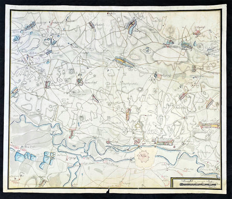
1755 Kloch Antique Original Hand Drawn Manuscript Military Map of Nysa Poland.
- Title : (Neisse) Nysa
- Ref #: 35639
-
Condition: (A+) Fine Condition
- Size: 21 3/4in x 18in (557mm x 460mm)
- Date : 1755-60
- Price: $575US
Description:
A wonderful large unique, original antique hand drawn military manuscript map on laid 18th century paper with a large French Imperial Fleur De Lis watermark.
This original unique hand drawn, hand coloured antique military map of the fortifications around the City and villages of the ancient Silesian city of Niessa or Nysa, now situated mainly in Poland with parts in Germany & Czech Republic, was hand drawn by a Prussian Military Cartographer Kloch, name inscribed in scale cartouche, was drawn in the mid to late 1750s, as it includes the Nysa fortifications known as Fort Prussia built between 1743-45.
General Definitions:
Paper thickness and quality: - Heavy and stable
Paper color : - off white
Age of map color: - Original
Colors used: - Yellow, green, blue, pink
General color appearance: - Authentic
Paper size: - 21 3/4in x 18in (557mm x 460mm)
Plate size: - 21 3/4in x 18in (557mm x 460mm)
Margins: - Min 1/2in (12mm)
Imperfections:
Margins: - Small section missing from bottom margin into border.
Plate area: - None
Verso: - Several small tears repaired to margins, not affecting the image
Background:
During the mid-18th century, the city of Nysa (Neisse) in Silesia, now located in present-day Poland, was a significant strategic location that witnessed several sieges between the Prussian and Austrian forces. The sieges were part of the larger conflict known as the War of the Austrian Succession (1740-1748) and the subsequent Seven Years' War (1756-1763).
The first major siege of Nysa occurred in 1741 during the War of the Austrian Succession. The Prussian army, led by King Frederick II (Frederick the Great), laid siege to the city, which was held by Austrian forces. The Prussian forces employed siege tactics, such as constructing trenches, artillery bombardment, and attempts to breach the city's defenses. After a protracted period of resistance, the Austrians eventually surrendered, and Nysa fell into Prussian control.
However, the city changed hands several times during the subsequent years of conflict. In 1742, as part of the Treaty of Breslau, Nysa was returned to Austrian control. But in 1745, during the Second Silesian War, the Prussians launched another siege and recaptured the city, fortifying it as a crucial stronghold in their territorial ambitions.
The city experienced further sieges during the Seven Years' War, which began in 1756. In 1758, the Austrian army, under the command of General Ernst Gideon von Laudon, laid siege to Nysa in an attempt to retake it from the Prussians. The siege lasted for several months, with both sides engaging in fierce combat and extensive bombardment. However, the Prussian defenders managed to hold their ground, and the Austrians eventually lifted the siege without capturing the city.
The sieges of Nysa in the mid-18th century were characterized by the use of traditional siege warfare techniques, including the construction of trenches, siege towers, and the deployment of artillery. The defending forces within the city would have employed various defensive measures, such as reinforcing the fortifications, counter-battery fire, and attempting to repel any breaches made by the besiegers.
These sieges played a significant role in the broader context of the conflicts between Prussia and Austria over control of Silesia. They showcased the strategic importance of Nysa and the determination of both sides to gain control of this key stronghold. The sieges of Nysa during this period serve as a testament to the military tactics and strategies employed by the Prussian and Austrian forces and the hardships faced by the soldiers and civilians caught in the midst of these conflicts.
Please note all items auctioned are genuine, we do not sell reproductions. A Certificate of Authenticity (COA) can be issued on request.
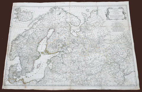
1758 D Anville Very Large Antique Map of Norway Sweden Iceland, Baltics & Russia
- Title : Seconde Partie de la Carte D Europe contenant Le Danemark et la Norwege, La Suede et la Russie....MDCCLVIII
- Size: 40 1/2in x 29 1/2in (1.02m x 760mm)
- Condition: (A) Very Good Condition
- Date : 1758
- Ref #: 92308
Description:
This scarce, very large (40in x 29in) highly detail map of Northern Europe Norway, Sweden, Lithuania, Baltic Countries and European Russia - was engraved in 1758 - dated in the title cartouche - by George De La Haye and was published by Jean Baptiste Bourguignon D\'Anville in his large elephant folio atlas Atlas Generale.
General Definitions:
Paper thickness and quality: - Heavy and stable
Paper color : - off white
Age of map color: - Original
Colors used: - Yellow, Green, pink
General color appearance: - Authentic
Paper size: - 40 1/2in x 29 1/2in (1.02m x 760mm)
Plate size: - 40in x 28 1/2in (1.0m x 725mm)
Margins: - Min 1/2in (12mm)
Imperfections:
Margins: - Light toning
Plate area: - Folds as issued, light separation at corners of folds
Verso: - Age toning
Background:
Before the fifteenth century the people of Southern Europe had little geographical knowledge of the Scandinavian World except from sketchy detail shown in the Catalan Atlas (1375) and on a number of portolani embracing Denmark and the southern tip of Norway. It was not until 1427 that a manuscript map prepared about that time by Claudius Clavus (b.1388) a Dane who spent some time in Rome, made available to scholars a tolerable outline of the northern countries and Greenland. That was to remain the best map available for the rest of the century and it was used as the basis for maps of Scandinavia in early printed editions of Ptolemy. Others by Nicolaus Cusanus (1491) and Ehrhard Etzlaub (c. 1492) followed but, needless to say, these are extremely rare; even the later maps by Olaus Magnus and Marcus Jordan, where they have survived at all , are known only by a very few examples. In fact, apart from the rare appearance of an early Ptolemy map, the oldest of Scandinavia which a collector is likely to find are those of Munster\'s Cosmograhy first published in 1544. In the following centuries the few maps and charts complied in Scandinavia were usually published in Amsterdam, Antwerp, Paris or Nuremberg, the most important maps often being incorporated in the major Dutch, French & German Atlases. (Ref: Tooley; M&B)
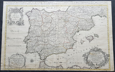
1696 Alexis Jaillot Large Antique Map of Spain, Portugal & Balearic Islands
- Title : L Espagne divisee en tous ses Royaumes et Principautes...Chez H Jaillot....1696
- Size: 36 1/2in x 23in (930mm x 585mm)
- Condition: (B) Good Condition
- Date : 1696
- Ref #: 35001
Description:
This very large, hand coloured original antique map of Spain & Portugal, by Alexis Hubert Jaillot - after Nicolas Sanson - was engraved in 1696 - the date is engraved in the title cartouche.
General Definitions:
Paper thickness and quality: - Heavy and stable
Paper color : - off white
Age of map color: - Original
Colors used: - Yellow, green, blue, pink
General color appearance: - Authentic
Paper size: - 36 1/2in x 23in (930mm x 585mm)
Plate size: - 35in x 23in (845mm x 600mm)
Margins: - Min 1/2in (12mm)
Imperfections:
Margins: - Soiling and creasing in margins
Plate area: - Light uplift along folds, soiling & creasing to bottom of map
Verso: - Soiling, creasing, old neutralised tape residue
Background:
In 1469, the crowns of the Christian kingdoms of Castile and Aragon were united by the marriage of Isabella I of Castile and Ferdinand II of Aragon. 1478 commenced the completion of the conquest of the Canary Islands and in 1492, the combined forces of Castile and Aragon captured the Emirate of Granada from its last ruler Muhammad XII, ending the last remnant of a 781-year presence of Islamic rule in Iberia. That same year, Spains Jews were ordered to convert to Catholicism or face expulsion from Spanish territories during the Spanish Inquisition. As many as 200,000 Jews were expelled from Spain. This was followed by expulsions in 1493 in Aragonese Sicily and Portugal in 1497. The Treaty of Granada guaranteed religious tolerance towards Muslims, for a few years before Islam was outlawed in 1502 in the Kingdom of Castile and 1527 in the Kingdom of Aragon, leading to Spains Muslim population becoming nominally Christian Moriscos. A few decades after the Morisco rebellion of Granada known as the War of the Alpujarras, a significant proportion of Spains formerly-Muslim population was expelled, settling primarily in North Africa. From 1609–14, over 300,000 Moriscos were sent on ships to North Africa and other locations, and, of this figure, around 50,000 died resisting the expulsion, and 60,000 died on the journey.
The year 1492 also marked the arrival of Christopher Columbus in the New World, during a voyage funded by Isabella. Columbuss first voyage crossed the Atlantic and reached the Caribbean Islands, beginning the European exploration and conquest of the Americas, although Columbus remained convinced that he had reached the Orient. Large numbers of indigenous Americans died in battle against the Spaniards during the conquest, while others died from various other causes. Some scholars consider the initial period of the Spanish conquest— from Columbuss first landing in the Bahamas until the middle of the sixteenth century—as marking the most egregious case of genocide in the history of mankind. The death toll may have reached some 70 million indigenous people (out of 80 million) in this period.
The colonisation of the Americas started with conquistadores like Hernán Cortés and Francisco Pizarro. Miscegenation was the rule between the native and the Spanish cultures and people. Juan Sebastian Elcano completed the first voyage around the world in human history, the Magellan-Elcano circumnavigation. Florida was colonised by Pedro Menéndez de Avilés when he founded St. Augustine, Florida and then defeated an attempt led by the French Captain Jean Ribault to establish a French foothold in Spanish Florida territory. St. Augustine became a strategic defensive base for Spanish ships full of gold and silver sailing to Spain. Andrés de Urdaneta discovered the tornaviaje or return route from the Philippines to Mexico, making possible the Manila galleon trading route. The Spanish once again encountered Islam, but this time in Southeast Asia and in order to incorporate the Philippines, Spanish expeditions organised from newly Christianised Mexico had invaded the Philippine territories of the Sultanate of Brunei. The Spanish considered the war with the Muslims of Brunei and the Philippines, a repeat of the Reconquista. The Spanish explorer Blas Ruiz intervened in Cambodias succession and installed Crown Prince Barom Reachea II as puppet.
As Renaissance New Monarchs, Isabella and Ferdinand centralised royal power at the expense of local nobility, and the word España, whose root is the ancient name Hispania, began to be commonly used to designate the whole of the two kingdoms. With their wide-ranging political, legal, religious and military reforms, Spain emerged as the first world power. The death of their son Prince John caused the Crown to pass to Charles I (the Emperor Charles V), son of Juana la Loca.
The unification of the crowns of Aragon and Castile by the marriage of their sovereigns laid the basis for modern Spain and the Spanish Empire, although each kingdom of Spain remained a separate country socially, politically, legally, and in currency and language.
There were two big revolts against the new Habsburg monarch and the more authoritarian and imperial-style crown: Revolt of the Comuneros in Castile and Revolt of the Brotherhoods in Majorca and Valencia. After years of combat, Comuneros Juan López de Padilla, Juan Bravo and Francisco Maldonado were executed and María Pacheco went into exile. Germana de Foix also finished with the revolt in the Mediterranean.
Habsburg Spain was Europes leading power throughout the 16th century and most of the 17th century, a position reinforced by trade and wealth from colonial possessions and became the worlds leading maritime power. It reached its apogee during the reigns of the first two Spanish Habsburgs—Charles I (1516–1556) and Philip II (1556–1598). This period saw the Italian Wars, the Schmalkaldic War, the Dutch Revolt, the War of the Portuguese Succession, clashes with the Ottomans, intervention in the French Wars of Religion and the Anglo-Spanish War.
Through exploration and conquest or royal marriage alliances and inheritance, the Spanish Empire expanded to include vast areas in the Americas, islands in the Asia-Pacific area, areas of Italy, cities in Northern Africa, as well as parts of what are now France, Germany, Belgium, Luxembourg, and the Netherlands. The first circumnavigation of the world was carried out in 1519–1521. It was the first empire on which it was said that the sun never set. This was an Age of Discovery, with daring explorations by sea and by land, the opening-up of new trade routes across oceans, conquests and the beginnings of European colonialism. Spanish explorers brought back precious metals, spices, luxuries, and previously unknown plants, and played a leading part in transforming the European understanding of the globe. The cultural efflorescence witnessed during this period is now referred to as the Spanish Golden Age. The expansion of the empire caused immense upheaval in the Americas as the collapse of societies and empires and new diseases from Europe devastated American indigenous populations. The rise of humanism, the Counter-Reformation and new geographical discoveries and conquests raised issues that were addressed by the intellectual movement now known as the School of Salamanca, which developed the first modern theories of what are now known as international law and human rights. Juan Luis Vives was another prominent humanist during this period.
Spains 16th century maritime supremacy was demonstrated by the victory over the Ottomans at Lepanto in 1571, and then after the setback of the Spanish Armada in 1588, in a series of victories against England in the Anglo-Spanish War of 1585–1604. However, during the middle decades of the 17th century Spains maritime power went into a long decline with mounting defeats against the United Provinces and then England; that by the 1660s it was struggling grimly to defend its overseas possessions from pirates and privateers.
The Protestant Reformation dragged the kingdom ever more deeply into the mire of religiously charged wars. The result was a country forced into ever expanding military efforts across Europe and in the Mediterranean. By the middle decades of a war- and plague-ridden 17th-century Europe, the Spanish Habsburgs had enmeshed the country in continent-wide religious-political conflicts. These conflicts drained it of resources and undermined the economy generally. Spain managed to hold on to most of the scattered Habsburg empire, and help the imperial forces of the Holy Roman Empire reverse a large part of the advances made by Protestant forces, but it was finally forced to recognise the separation of Portugal and the United Provinces, and eventually suffered some serious military reverses to France in the latter stages of the immensely destructive, Europe-wide Thirty Years War. In the latter half of the 17th century, Spain went into a gradual decline, during which it surrendered several small territories to France and England; however, it maintained and enlarged its vast overseas empire, which remained intact until the beginning of the 19th century.
The decline culminated in a controversy over succession to the throne which consumed the first years of the 18th century. The War of the Spanish Succession was a wide-ranging international conflict combined with a civil war, and was to cost the kingdom its European possessions and its position as one of the leading powers on the Continent. During this war, a new dynasty originating in France, the Bourbons, was installed. Long united only by the Crown, a true Spanish state was established when the first Bourbon king, Philip V, united the crowns of Castile and Aragon into a single state, abolishing many of the old regional privileges and laws.
The 18th century saw a gradual recovery and an increase in prosperity through much of the empire. The new Bourbon monarchy drew on the French system of modernising the administration and the economy. Enlightenment ideas began to gain ground among some of the kingdoms elite and monarchy. Bourbon reformers created formal disciplined militias across the Atlantic. Spain needed every hand it could take during the seemingly endless wars of the eighteenth century—the Spanish War of Succession or Queen Annes War (1702–13), the War of Jenkins Ear (1739–42) which became the War of the Austrian Succession (1740–48), the Seven Years War (1756–63) and the Anglo-Spanish War (1779–83)—and its new disciplined militias served around the Atlantic as needed.
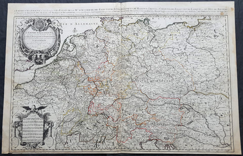
1692 Jaillot Large Antique Map of Allemagne or German Empire, Central Europe
- Title : L Empire D Allemagne distingue suivant l´etenedu de tous les estates principautes et souverainites...A Paris Chez...H Jaillot....1692
- Size: 37in x 24in (940mm x 615mm)
- Condition: (A+) Fine Condition
- Date : 1692
- Ref #: 16382
Description:
This very large, hand coloured original antique map of the German Empire and central Europe in the late 17th century by Alexis Hubert Jaillot - after Nicolas Sanson - was engraved in 1692 - the date is engraved in the dedication cartouche.
General Definitions:
Paper thickness and quality: - Heavy and stable
Paper color : - off white
Age of map color: - Original
Colors used: - Yellow, green, blue, pink
General color appearance: - Authentic
Paper size: - 37in x 24in (940mm x 615mm)
Plate size: - 36in x 23in (930mm x 605mm)
Margins: - Min 1/2in (12mm)
Imperfections:
Margins: - None
Plate area: - None
Verso: - None
Background:
The name Allemagne for Germany and the other similar-sounding names above are derived from the southern Germanic Alemanni, a Suebic tribe or confederation in todays Alsace, parts of Baden-Württemberg and Switzerland.
In 800, the Frankish king Charlemagne was crowned emperor and founded the Carolingian Empire, which was later divided in 843 among his heirs. Following the break up of the Frankish Realm, for 900 years, the history of Germany was intertwined with the history of the Holy Roman Empire, which subsequently emerged from the eastern portion of Charlemagnes original empire. The territory initially known as East Francia stretched from the Rhine in the west to the Elbe River in the east and from the North Sea to the Alps. The Ottonian rulers (919–1024) consolidated several major duchies and the German king Otto I was crowned Holy Roman Emperor of these regions in 962. In 996 Gregory V became the first German Pope, appointed by his cousin Otto III, whom he shortly after crowned Holy Roman Emperor. The Holy Roman Empire absorbed northern Italy and Burgundy under the reign of the Salian emperors (1024–1125), although the emperors lost power through the Investiture controversy.
In the 12th century, under the Hohenstaufen emperors (1138–1254), German princes increased their influence further south and east into territories inhabited by Slavs; they encouraged German settlement in these areas, called the eastern settlement movement (Ostsiedlung). Members of the Hanseatic League, which included mostly north German cities and towns, prospered in the expansion of trade. In the south, the Greater Ravensburg Trade Corporation (Große Ravensburger Handelsgesellschaft) served a similar function. The edict of the Golden Bull issued in 1356 by Emperor Charles IV provided the basic constitutional structure of the Empire and codified the election of the emperor by seven prince-electors who ruled some of the most powerful principalities and archbishoprics.
Population declined in the first half of the 14th century, starting with the Great Famine in 1315, followed by the Black Death of 1348–50. Despite the decline, however, German artists, engineers, and scientists developed a wide array of techniques similar to those used by the Italian artists and designers of the time who flourished in such merchant city-states as Venice, Florence and Genoa. Artistic and cultural centres throughout the German states produced such artists as the Augsburg painters Hans Holbein and his son, and Albrecht Dürer. Johannes Gutenberg introduced moveable-type printing to Europe, a development that laid the basis for the spread of learning to the masses.
In 1517, the Wittenberg priest Martin Luther nailed the Ninety-Five Theses to the church door, challenging the practice of selling of indulgences. He was subsequently excommunicated in the papal bull Exsurge Domine in 1520, and his followers were condemned in the 1521 Diet of Worms, which divided Western Christianity. In 1555, the Peace of Augsburg tolerated the Evangelical faith (now called Lutheranism) as an acceptable alternative to Catholicism, but also decreed that the faith of the prince was to be the faith of his subjects, a principle called cuius regio, eius religio. The agreement at Augsburg failed to address other religious creed: for example, the Reformed faith was still considered a heresy and the principle did not address the possible conversion of an ecclesiastic ruler, such as happened in Electorate of Cologne in 1583. However, in practice Calvinists were given protection under the Augsburg Confession Variata modified upon request by Philip Melanchthon.
From the Cologne War until the end of the Thirty Years Wars (1618–1648), religious conflict devastated German lands. The latter reduced the overall population of the German states by about 30 per cent, and in some places, up to 80 per cent. The Peace of Westphalia ended religious warfare among the Imperial Estates of the Holy Roman Empire. Their mostly German-speaking rulers were able to choose either Roman Catholicism, Lutheranism, or the Reformed faith as their official religion after 1648.
In the 18th century, the Holy Roman Empire consisted of approximately 1,800 territories. The elaborate legal system initiated by a series of Imperial Reforms (approximately 1450–1555) created the Imperial Estates and provided for considerable local autonomy among ecclesiastical, secular, and hereditary states, reflected in the Imperial Diet. The House of Habsburg held the imperial crown from 1438 until the death of Charles VI in 1740. Having no male heirs, he had convinced the Electors to retain Habsburg hegemony in the office of the emperor by agreeing to the Pragmatic Sanction of 1713. This was finally settled through the War of Austrian Succession; in the Treaty of Aix-la-Chapelle, Charles VIs daughter Maria Theresa ruled the Empire as Empress Consort when her husband, Francis I, became Holy Roman Emperor. From 1740, the dualism between the Austrian Habsburg Monarchy and the Kingdom of Prussia dominated the German history.
In 1772, then again in 1793 and 1795, the two dominant German states of Prussia and Austria, along with the Russian Empire, agreed to the Partitions of Poland; dividing among themselves the lands of the Polish–Lithuanian Commonwealth. As a result of the partitions, millions of Polish speaking inhabitants fell under the rule of the two German monarchies. However, the annexed territories though incorporated into the Kingdom of Prussia and the Habsburg Realm, were not legally considered as a part of the Holy Roman Empire. During the period of the French Revolutionary Wars, along with the arrival of the Napoleonic era and the subsequent final meeting of the Imperial Diet, most of the secular Free Imperial Cities were annexed by dynastic territories; the ecclesiastical territories were secularised and annexed. In 1806 the Imperium was dissolved; many German states, particularly the Rhineland states, fell under the influence of France. Until 1815, France, Russia, Prussia and the Habsburgs (Austria) competed for hegemony in the German states during the Napoleonic Wars.
Following the fall of Napoleon, the Congress of Vienna (convened in 1814) founded the German Confederation (Deutscher Bund), a loose league of 39 sovereign states. The appointment of the Emperor of Austria as the permanent president of the Confederation reflected the Congresss failure to accept Prussias rising influence among the German states, and acerbated the long-standing competition between the Hohenzollern and Habsburg interests. Disagreement within restoration politics partly led to the rise of liberal movements, followed by new measures of repression by Austrian statesman Metternich. The Zollverein, a tariff union, furthered economic unity in the German states.
National and liberal ideals of the French Revolution gained increasing support among many, especially young, Germans. The Hambach Festival in May 1832 was a main event in support of German unity, freedom and democracy. In the light of a series of revolutionary movements in Europe, which established a republic in France, intellectuals and commoners started the Revolutions of 1848 in the German states. King Frederick William IV of Prussia was offered the title of Emperor, but with a loss of power; he rejected the crown and the proposed constitution, leading to a temporary setback for the movement.
Foundation of the German Empire in Versailles, 1871. Bismarck is at the centre in a white uniform.
King William I appointed Otto von Bismarck as the new Minister President of Prussia in 1862. Bismarck successfully concluded war on Denmark in 1864, which promoted German over Danish interests in the Jutland peninsula. The subsequent (and decisive) Prussian victory in the Austro-Prussian War of 1866 enabled him to create the North German Confederation (Norddeutscher Bund) which excluded Austria from the federations affairs. After the French defeat in the Franco-Prussian War, the German princes proclaimed the founding of the German Empire in 1871 at Versailles, uniting all the scattered parts of Germany except Austria and the German-speaking parts of Switzerland. Prussia was the dominant constituent state of the new empire; the Hohenzollern King of Prussia ruled as its concurrent Emperor, and Berlin became its capital.
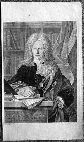
1712 Wilhelm Winter & Joannes Krenckel Large Antique Print Portrait of Johann Baptiste Homann
- Title : Joannes Baptista Homann
- Date : 1712
- Condition: (A+) Fine Condition
- Ref: 43162
- Size: 21in x 11 3/4in (560mm x 295mm)
Description:
This finely engraved original antique print, a portrait of the early 18th century German Cartographer Johann Baptiste Homann after a painting by Joannes Krenckel was engraved by Wilhelm Winter and published in 1716 for Homann's Grosser Atlas.
Stunning full portrait of the Imperial Geographer of the Holy Roman Empire, Johann Baptist Homann (1664-1724) who was born in the Bavarian town of Kammlach.
Educated at a Jesuit school, he eventually became a member of the Prussian Academy of Sciences. As an Imperial Geographer he had special printing privileges, which were not only the best reference for customers but also gave him exclusive rights in his various endeavours as an engraver, publisher, cartographer, and a scientist. Homann died in Nuremberg, with the company, under his heirs, lasting until 1848.
After a painting by Joannes Krenckel (1688–1722), engraved by Wilhelm Winter (1696–1765). (Ref: Tooley; M&B)
General Description:
Paper thickness and quality: - Heavy and stable
Paper color: - Off white
Age of map color: -
Colors used: -
General color appearance: -
Paper size: - 21in x 11 3/4in (560mm x 295mm)
Plate size: - 15 1/4in x 11in (390mm x 280mm)
Margins: - Min 1/4in (7mm)
Imperfections:
Margins: - Light soiling bottom right corner
Plate area: - None
Verso: - None

1710 John Senex Large Antique Map of Germany, Central Europe, Baltic to Austria
- Title : Germany Corrected from the Observations of the Royal Society at London and the Royal Academy at Paris by John Senex FRS....1710
- Size: 41in x 26 1/2in (1.040m x 660mm)
- Condition: (A) Very Good Condition
- Date : 1710
- Ref #: 24906
Description:
This large hand coloured original antique map of Germany was engraved by John Senex in 1710 - dated - and was published in Senex Elephant Folio Atlas.
This map is in VG condition, with these large scale maps being scarce due mainly to their size with damage and loss over time inevitable.
General Definitions:
Paper thickness and quality: - Heavy and stable
Paper color : - off white
Age of map color: - Original
Colors used: - Yellow, green, blue, pink
General color appearance: - Authentic
Paper size: - 41in x 26 1/2in (1.040m x 660mm)
Plate size: - 40in x 26in (1.00m x 650mm)
Margins: - Min 1/2in (12mm)
Imperfections:
Margins: - Chipping to bottom margin
Plate area: - Age toning along centerfold, light creasing
Verso: - Light creasing.
Background:
Because of Germanys long history as a non-united region of distinct tribes and states before January 1871, there are many widely varying names of Germany in different languages, perhaps more so than for any other European nation. For example, in the German language, the country is known as Deutschland, in Spanish as Alemania, in French as Allemagne, in Italian as Germania (although Germans are called tedeschi), in Polish as Niemcy, and in Finnish as Saksa.
In 800, the Frankish king Charlemagne was crowned emperor and founded the Carolingian Empire, which was later divided in 843 among his heirs. Following the break up of the Frankish Realm, for 900 years, the history of Germany was intertwined with the history of the Holy Roman Empire, which subsequently emerged from the eastern portion of Charlemagnes original empire. The territory initially known as East Francia stretched from the Rhine in the west to the Elbe River in the east and from the North Sea to the Alps. The Ottonian rulers (919–1024) consolidated several major duchies and the German king Otto I was crowned Holy Roman Emperor of these regions in 962. In 996 Gregory V became the first German Pope, appointed by his cousin Otto III, whom he shortly after crowned Holy Roman Emperor. The Holy Roman Empire absorbed northern Italy and Burgundy under the reign of the Salian emperors (1024–1125), although the emperors lost power through the Investiture controversy.
In the 12th century, under the Hohenstaufen emperors (1138–1254), German princes increased their influence further south and east into territories inhabited by Slavs; they encouraged German settlement in these areas, called the eastern settlement movement (Ostsiedlung). Members of the Hanseatic League, which included mostly north German cities and towns, prospered in the expansion of trade. In the south, the Greater Ravensburg Trade Corporation (Große Ravensburger Handelsgesellschaft) served a similar function. The edict of the Golden Bull issued in 1356 by Emperor Charles IV provided the basic constitutional structure of the Empire and codified the election of the emperor by seven prince-electors who ruled some of the most powerful principalities and archbishoprics.
Population declined in the first half of the 14th century, starting with the Great Famine in 1315, followed by the Black Death of 1348–50. Despite the decline, however, German artists, engineers, and scientists developed a wide array of techniques similar to those used by the Italian artists and designers of the time who flourished in such merchant city-states as Venice, Florence and Genoa. Artistic and cultural centres throughout the German states produced such artists as the Augsburg painters Hans Holbein and his son, and Albrecht Dürer. Johannes Gutenberg introduced moveable-type printing to Europe, a development that laid the basis for the spread of learning to the masses.
In 1517, the Wittenberg priest Martin Luther nailed the Ninety-Five Theses to the church door, challenging the practice of selling of indulgences. He was subsequently excommunicated in the papal bull Exsurge Domine in 1520, and his followers were condemned in the 1521 Diet of Worms, which divided Western Christianity. In 1555, the Peace of Augsburg tolerated the Evangelical faith (now called Lutheranism) as an acceptable alternative to Catholicism, but also decreed that the faith of the prince was to be the faith of his subjects, a principle called cuius regio, eius religio. The agreement at Augsburg failed to address other religious creed: for example, the Reformed faith was still considered a heresy and the principle did not address the possible conversion of an ecclesiastic ruler, such as happened in Electorate of Cologne in 1583. However, in practice Calvinists were given protection under the Augsburg Confession Variata modified upon request by Philip Melanchthon.
From the Cologne War until the end of the Thirty Years Wars (1618–1648), religious conflict devastated German lands. The latter reduced the overall population of the German states by about 30 per cent, and in some places, up to 80 per cent. The Peace of Westphalia ended religious warfare among the Imperial Estates of the Holy Roman Empire. Their mostly German-speaking rulers were able to choose either Roman Catholicism, Lutheranism, or the Reformed faith as their official religion after 1648.
In the 18th century, the Holy Roman Empire consisted of approximately 1,800 territories. The elaborate legal system initiated by a series of Imperial Reforms (approximately 1450–1555) created the Imperial Estates and provided for considerable local autonomy among ecclesiastical, secular, and hereditary states, reflected in the Imperial Diet. The House of Habsburg held the imperial crown from 1438 until the death of Charles VI in 1740. Having no male heirs, he had convinced the Electors to retain Habsburg hegemony in the office of the emperor by agreeing to the Pragmatic Sanction of 1713. This was finally settled through the War of Austrian Succession; in the Treaty of Aix-la-Chapelle, Charles VIs daughter Maria Theresa ruled the Empire as Empress Consort when her husband, Francis I, became Holy Roman Emperor. From 1740, the dualism between the Austrian Habsburg Monarchy and the Kingdom of Prussia dominated the German history.
In 1772, then again in 1793 and 1795, the two dominant German states of Prussia and Austria, along with the Russian Empire, agreed to the Partitions of Poland; dividing among themselves the lands of the Polish–Lithuanian Commonwealth. As a result of the partitions, millions of Polish speaking inhabitants fell under the rule of the two German monarchies. However, the annexed territories though incorporated into the Kingdom of Prussia and the Habsburg Realm, were not legally considered as a part of the Holy Roman Empire. During the period of the French Revolutionary Wars, along with the arrival of the Napoleonic era and the subsequent final meeting of the Imperial Diet, most of the secular Free Imperial Cities were annexed by dynastic territories; the ecclesiastical territories were secularised and annexed. In 1806 the Imperium was dissolved; many German states, particularly the Rhineland states, fell under the influence of France. Until 1815, France, Russia, Prussia and the Habsburgs (Austria) competed for hegemony in the German states during the Napoleonic Wars.
Following the fall of Napoleon, the Congress of Vienna (convened in 1814) founded the German Confederation (Deutscher Bund), a loose league of 39 sovereign states. The appointment of the Emperor of Austria as the permanent president of the Confederation reflected the Congresss failure to accept Prussias rising influence among the German states, and acerbated the long-standing competition between the Hohenzollern and Habsburg interests. Disagreement within restoration politics partly led to the rise of liberal movements, followed by new measures of repression by Austrian statesman Metternich. The Zollverein, a tariff union, furthered economic unity in the German states.
National and liberal ideals of the French Revolution gained increasing support among many, especially young, Germans. The Hambach Festival in May 1832 was a main event in support of German unity, freedom and democracy. In the light of a series of revolutionary movements in Europe, which established a republic in France, intellectuals and commoners started the Revolutions of 1848 in the German states. King Frederick William IV of Prussia was offered the title of Emperor, but with a loss of power; he rejected the crown and the proposed constitution, leading to a temporary setback for the movement.
Foundation of the German Empire in Versailles, 1871. Bismarck is at the centre in a white uniform.
King William I appointed Otto von Bismarck as the new Minister President of Prussia in 1862. Bismarck successfully concluded war on Denmark in 1864, which promoted German over Danish interests in the Jutland peninsula. The subsequent (and decisive) Prussian victory in the Austro-Prussian War of 1866 enabled him to create the North German Confederation (Norddeutscher Bund) which excluded Austria from the federations affairs. After the French defeat in the Franco-Prussian War, the German princes proclaimed the founding of the German Empire in 1871 at Versailles, uniting all the scattered parts of Germany except Austria and the German-speaking parts of Switzerland. Prussia was the dominant constituent state of the new empire; the Hohenzollern King of Prussia ruled as its concurrent Emperor, and Berlin became its capital.
In the Gründerzeit period following the unification of Germany, Bismarcks foreign policy as Chancellor of Germany under Emperor William I secured Germanys position as a great nation by forging alliances, isolating France by diplomatic means, and avoiding war. Under Wilhelm II, Germany, like other European powers, took an imperialistic course, leading to friction with neighbouring countries. Most alliances in which Germany had previously been involved were not renewed. This resulted in the creation of a dual alliance with the multinational realm of Austria-Hungary, promoting at least benevolent neutrality if not outright military support. Subsequently, the Triple Alliance of 1882 included Italy, completing a Central European geographic alliance that illustrated German, Austrian and Italian fears of incursions against them by France and/or Russia. Similarly, Britain, France and Russia also concluded alliances that would protect them against Habsburg interference with Russian interests in the Balkans or German interference against France.
At the Berlin Conference in 1884, Germany claimed several colonies including German East Africa, German South West Africa, Togoland, and Kamerun. Later, Germany further expanded its colonial empire to include German New Guinea, German Micronesia and German Samoa in the Pacific, and Kiautschou Bay in China. In what became known as the First Genocide of the Twentieth-Century, between 1904 and 1907, the German colonial government in South West Africa (present-day Namibia) ordered the annihilation of the local Herero and Namaqua peoples, as a punitive measure for an uprising against German colonial rule. In total, around 100,000 people—80% of the Herero and 50% of the Namaqua—perished from imprisonment in concentration camps, where the majority died of disease, abuse, and exhaustion, or from dehydration and starvation in the countryside after being deprived of food and water.
The assassination of Austrias crown prince on 28 June 1914 provided the pretext for the Austrian Empire to attack Serbia and trigger World War I. After four years of warfare, in which approximately two million German soldiers were killed, a general armistice ended the fighting on 11 November, and German troops returned home. In the German Revolution (November 1918), Emperor Wilhelm II and all German ruling princes abdicated their positions and responsibilities. Germanys new political leadership signed the Treaty of Versailles in 1919. In this treaty, Germany, as part of the Central Powers, accepted defeat by the Allies in one of the bloodiest conflicts of all time. Germans perceived the treaty as humiliating and unjust and it was later seen by historians as influential in the rise of Adolf Hitler. After the defeat in the First World War, Germany lost around 13% of its European territory (areas predominantly inhabited by ethnic Polish, French and Danish populations, which were lost following the Greater Poland Uprising, the return of Alsace-Lorraine and the Schleswig plebiscites), and all of its colonial possessions in Africa and the South Sea.
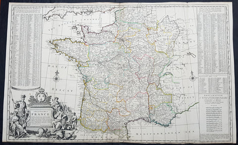
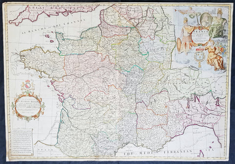
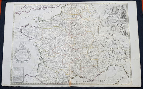
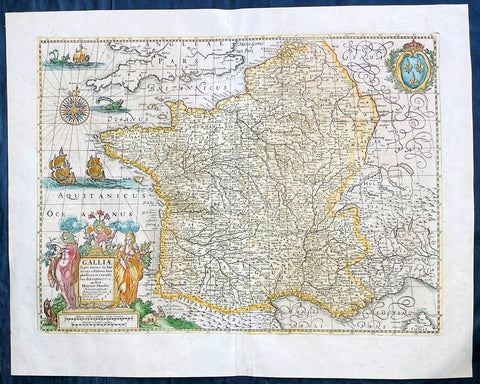
1720 Herman Moll Large Antique Map of France in Provinces - Pre Revolution
- Title : A New and Exact Map of France Divided into all its Provinces...by H Moll Geographer
- Ref #: 93416
- Size: 40in x 24 1/2in (1.010m x 625mm)
- Date : 1720
- Condition: (A+) Fine Condition
Description:
This very large beautifully hand coloured original copper-plate engraved antique map of France by Herman Moll was published in 1720 in the atlas The World Described, or a New and Correct Sett of Maps by John Bowles, Thomas Bowles, Philip Overton & John King of London.
In the 18th century many large-scale maps were published by the likes of John Senex and Herman Moll, this trend continued until the end of private mapping in the early 19th century when it was replaced by Ordnance Survey maps.
General Definitions:
Paper thickness and quality: - Heavy and stable
Paper color : - off white
Age of map color: - Early
Colors used: - Yellow, green, blue, pink
General color appearance: - Authentic
Paper size: - 40in x 24 1/2in (1.010m x 625mm)
Plate size: - 39 1/2in x 24in (1.00m x 620mm)
Margins: - Min 1/8in (3mm)
Imperfections:
Margins: - Bottom margin cropped to plate mark
Plate area: - Folds as issued
Verso: - Folds as issued
Background:
The Carolingian dynasty ruled France until 987, when Hugh Capet, Duke of France and Count of Paris, was crowned King of the Franks. His descendants—the Capetians, the House of Valois, and the House of Bourbon—progressively unified the country through wars and dynastic inheritance into the Kingdom of France, which was fully declared in 1190 by Philip II Augustus. The French nobility played a prominent role in most Crusades in order to restore Christian access to the Holy Land. French knights made up the bulk of the steady flow of reinforcements throughout the two-hundred-year span of the Crusades, in such a fashion that the Arabs uniformly referred to the crusaders as Franj caring little whether they really came from France. The French Crusaders also imported the French language into the Levant, making French the base of the lingua franca (litt. Frankish language) of the Crusader states. French knights also made up the majority in both the Hospital and the Temple orders. The latter, in particular, held numerous properties throughout France and by the 13th century were the principal bankers for the French crown, until Philip IV annihilated the order in 1307. The Albigensian Crusade was launched in 1209 to eliminate the heretical Cathars in the southwestern area of modern-day France. In the end, the Cathars were exterminated and the autonomous County of Toulouse was annexed into the crown lands of France. Later kings expanded their domain to cover over half of modern continental France, including most of the north, centre and west of France. Meanwhile, the royal authority became more and more assertive, centred on a hierarchically conceived society distinguishing nobility, clergy, and commoners.
From the 11th century, the House of Plantagenet, the rulers of the County of Anjou, succeeded in establishing its dominion over the surrounding provinces of Maine and Touraine, then progressively built an empire that spanned from England to the Pyrenees and covering half of modern France. Tensions between the kingdom of France and the Plantagenet empire would last a hundred years, until Philip Augustus of France conquered between 1202 and 1214 most of the continental possessions of the empire, leaving England and Aquitaine to the Plantagenets. Following the Battle of Bouvines, the Angevin court retreated to England, but persistent Capetian–Plantagenet rivalry would paved the way for another conflict.
Charles IV the Fair died without an heir in 1328. Under the rules of the Salic law the crown of France could not pass to a woman nor could the line of kingship pass through the female line. Accordingly, the crown passed to Philip of Valois, a cousin of Charles, rather than through the female line to Charles nephew, Edward of Plantagenet, who would soon become Edward III of England. During the reign of Philip of Valois, the French monarchy reached the height of its medieval power. Philips seat on the throne was contested by Edward III of England and in 1337, on the eve of the first wave of the Black Death, England and France went to war in what would become known as the Hundred Years War. The exact boundaries changed greatly with time, but French landholdings of the English Kings remained extensive for decades. With charismatic leaders, such as Joan of Arc and La Hire, strong French counterattacks won back English continental territories. Like the rest of Europe, France was struck by the Black Death; half of the 17 million population of France died.
The French Renaissance saw a spectacular cultural development and the first standardisation of the French language, which would become the official language of France and the language of Europes aristocracy. It also saw a long set of wars, known as the Italian Wars, between France and the House of Habsburg. French explorers, such as Jacques Cartier or Samuel de Champlain, claimed lands in the Americas for France, paving the way for the expansion of the First French colonial empire. The rise of Protestantism in Europe led France to a civil war known as the French Wars of Religion, where, in the most notorious incident, thousands of Huguenots were murdered in the St. Bartholomews Day massacre of 1572. The Wars of Religion were ended by Henry IVs Edict of Nantes, which granted some freedom of religion to the Huguenots. Spanish troops, the terror of Western Europe, assisted the Catholic side during the Wars of Religion in 1589–1594, and invaded northern France in 1597; after some skirmishing in the 1620s and 1630s, Spain and France returned to all-out war between 1635 and 1659. The war cost France 300,000 casualties.
Under Louis XIII, the energetic Cardinal Richelieu promoted the centralisation of the state and reinforced the royal power by disarming domestic power holders in the 1620s. He systematically destroyed castles of defiant lords and denounced the use of private violence (dueling, carrying weapons, and maintaining private army). By the end of 1620s, Richelieu established the royal monopoly of force as the doctrine. During Louis XIVs minority and the regency of Queen Anne and Cardinal Mazarin, a period of trouble known as the Fronde occurred in France. This rebellion was driven by the great feudal lords and sovereign courts as a reaction to the rise of royal absolute power in France.
The monarchy reached its peak during the 17th century and the reign of Louis XIV. By turning powerful feudal lords into courtiers at the Palace of Versailles, Louis XIVs personal power became unchallenged. Remembered for his numerous wars, he made France the leading European power. France became the most populous country in Europe and had tremendous influence over European politics, economy, and culture. French became the most-used language in diplomacy, science, literature and international affairs, and remained so until the 20th century. France obtained many overseas possessions in the Americas, Africa and Asia. Louis XIV also revoked the Edict of Nantes, forcing thousands of Huguenots into exile.
Under Louis XV, Louis XIVs great-grandson, France lost New France and most of its Indian possessions after its defeat in the Seven Years War (1756–63). Its European territory kept growing, however, with notable acquisitions such as Lorraine (1766) and Corsica (1770). An unpopular king, Louis XVs weak rule, his ill-advised financial, political and military decisions – as well as the debauchery of his court– discredited the monarchy, which arguably paved the way for the French Revolution 15 years after his death.
Louis XVI, Louis XVs grandson, actively supported the Americans, who were seeking their independence from Great Britain (realised in the Treaty of Paris (1783)). The financial crisis aggravated by Frances involvement in the American Revolutionary War was one of many contributing factors to the French Revolution. Much of the Enlightenment occurred in French intellectual circles, and major scientific breakthroughs and inventions, such as the discovery of oxygen (1778) and the first hot air balloon carrying passengers (1783), were achieved by French scientists. French explorers, such as Bougainville and Lapérouse, took part in the voyages of scientific exploration through maritime expeditions around the globe. The Enlightenment philosophy, in which reason is advocated as the primary source for legitimacy and authority, undermined the power of and support for the monarchy and helped pave the way for the French Revolution.
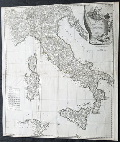
1743 D Anville & CA Coypel Large Antique Map of Italy, Sicily, Sardinia, Corsica
- Title : L Italie Publiee Sous Les Auspices De Monseigneur Le Duc D Orleans, Premier Prince Du Sang....Par L Sr D Anville...MDCCXLIII
- Date : 1743
- Condition: (A) Very Good Condition
- Ref: 92312
- Size: 32in x 28in (820mm x 710mm)
Description:
This large scarce original copper-plate engraved antique map of contemporary Italy, Sicily, Sardinia, Corsica & Malta by Charles-Antoine Coypel was engraved by Pierre-Alexandre Aveline (1702–1760) (both names engraved under cartouche) in 1743 - dated in cartouche - and was published by Jean-Baptiste Bourguinon D Anvilles in his large elephant folio atlas Atlas Generale.
A scarce and hard to find map with two famous names Charles-Antoine Coypel & Pierre-Alexandre Aveline engraved below the cartouche, I am assuming as both drawer & engraver.
General Definitions:
Paper thickness and quality: - Heavy and stable
Paper color : - off white
Age of map color: -
Colors used: -
General color appearance: -
Paper size: - 32in x 28in (820mm x 710mm)
Plate size: - 31 1/2in x 27in (810mm x 690mm)
Margins: - Min 1/8in (2mm)
Imperfections:
Margins: - Top margin cropped to border
Plate area: - Light creasing
Verso: - Creasing
Background:
Since classical times the countries bordering the enclosed waters of the Mediterranean had been well versed in the use of maps and sea charts and in Italy, more than anywhere else, the traditional knowledge was kept alive during the many hundreds of years following the collapse of the Roman Empire. By the thirteenth and fourteenth centuries the seamen of Venice, Genoa and Amalfi traded to far countries, from the Black Sea ports and the coasts of Palestine and Egypt in the East to Flanders and the southern coasts of England and Ireland in the West, their voyages guided by portulan charts and the use of the newly invented compass. For a time Italian supremacy in cartography passed to Aragon and the Catalan map makers based on Majorca, but by the year 1400 the power and wealth of the city states of Venice, Genoa, Florence and Milan surpassed any in Europe. Florence, especially, under the rule of the Medici family, became not only a great trading and financial centre but also the focal point of the rediscovery of the arts and learning of the ancient world. In this milieu a number of manuscript world maps were produced, of which one by Fra Mauro (c. 1459) is the most notable, but the event of the greatest importance in the history of cartography occurred in the year 1400 when a Florentine, Palla Strozzi, brought from Constantinople a Greek manuscript copy of Claudius Ptolemy\\\'s Geographia, which, 1,250 years after its compilation, came as a revelation to scholars in Western Europe. In the following fifty years or so manuscript copies, translated into Latin and other languages, became available in limited numbers but the invention of movable-type printing transformed the scene: the first copy without maps being printed in 1475 followed by many with copper-engraved maps, at Bologna in 1477, Rome 1478, 1490, 1507 and 1508, and Florence 1482.
About the year 1485 the first book of sea charts, compiled by Bartolommeo dalli Sonetti, was printed in Venice and in the first part of the sixteenth century a number of world maps were published, among them one compiled in 1506 by Giovanni Contarini, engraved by Francesco Rosselli, which was the first printed map to show the discoveries in the New World. In the following years there were many attractive and unusual maps of Islands (Isolano) by Bordone, Camocio and Porcacchi, but more important was the work of Giacomo (Jacopo) Gastaldi, a native of Piedmont who started life as an engineer in the service of the Venetian Republic before turning to cartography as a profession. His maps, produced in great variety and quantity, were beautifully drawn copperplate engravings and his style and techniques were widely copied by his contemporaries. From about 1550 to 1580 many of Gastaldi\\\'s maps appeared in the collections of maps known as Lafreri \\\'atlases\\\', a term applied to groups of maps by different cartographers brought together in one binding. As the contents of such collections varied considerably they were no doubt assembled at the special request of wealthy patrons and are now very rare indeed.
About this time, for a variety of historical and commercial reasons, Italy\\\'s position as the leading trading and financial nation rapidly declined and with it her superiority in cartography was lost to the vigorous new states in the Low Countries. That is not to say, of course, that Italian skills as map makers were lost entirely for it was not until 1620 that the first printed maps of Italy by an Italian, Giovanni Magini, appeared, and much later in the century there were fine maps by Giacomo de Rossi and Vincenzo Coronelli, the latter leading a revival of interest in cartography at the end of the century. Coronelli was also famous for the construction of magnificent large-size globes and for the foundation in Venice in 1680 of the first geographical society.
In the eighteenth century the best-known names are Antonio Zatta, Rizzi-Zannoni and Giovanni Cassini.
We ought to mention the work of Baptista Boazio who drew a series of maps in A Summarie and True Discourse of Sir Francis Drake\\\'s West Indian Voyage, published in 1588-89, and who is especially noted for a very fine map of Ireland printed in 1599 which was incorporated in the later editions of the Ortelius atlases. It is perhaps appropriate also to refer to two English map makers who spent many years in exile in Italy: the first, George Lily, famous for the splendid map of the British Isles issued in Rome in 1546, and the second, Robert Dudley, who exactly one hundred years later was responsible for the finest sea atlas of the day, Dell\\\' Arcano del Mare, published in Florence. Both of these are described in greater detail elsewhere in this handbook. (Ref: Tooley, Koeman)
1720 John Senex Large Antique Pre Revolutionary Map of France in Provinces
- Title : France Corrected from ye Observations made by the Royal Academy of Sciences at Paris by John Senex
- Size: 37in x 26in (940m x 660mm)
- Condition: (A) Very Good Condition
- Date : 1720
- Ref #: 81078
Description:
This large beautifully hand coloured original antique map of France was engraved for John Senex for publication in his Elephant Folio Atlas 1720.
These large scale maps are scarce due mainly to their size. Damage and loss over time is inevitable.
General Definitions:
Paper thickness and quality: - Heavy and stable
Paper color : - off white
Age of map color: - Original & later
Colors used: - Yellow, green, blue, pink
General color appearance: - Authentic
Paper size: - 37in x 26in (940m x 660mm)
Plate size: - 36 1/2in x 25 1/2in (930m x 650mm)
Margins: - Min 1/4in (8mm)
Imperfections:
Margins: - Bottom left corner extended from plate-mark
Plate area: - Folds as issued
Verso: - None
Background:
The history of French cartography can be traced to developments in the Middle Ages. This period was marked by improvements in measuring instruments and also by an upgrade of work in registers of all types.
The first map of France was drawn by Oronce Finé and printed in woodcuts in 1525. It testifies to the will of the political power to mark its presence on the territory; to affirm, to build limits, borders, to arrange its territory, and to consolidate the internal economic markets.
In the sixteenth century, Dieppe appeared as an important school of cartography. Pierre Desceliers allowed the realization of many maps. At the same time, the Portolan maps of the Portuguese sailors had the most recent knowledge obtained by the Dieppois sailors in their exploration of Canada.
Then, cartography progressed more and more, through the development of new techniques and by the will of the political powers to control their territories. Very powerful companies testify support to some of the cartographic missions at the end of the nineteenth century.
There were two decisive stages in cartography. One was determining longitude and latitude. Florence Trystram, 2001, the lawsuit of the stars is an account of the research of three French scientists that was done in South America, 1735-1771.
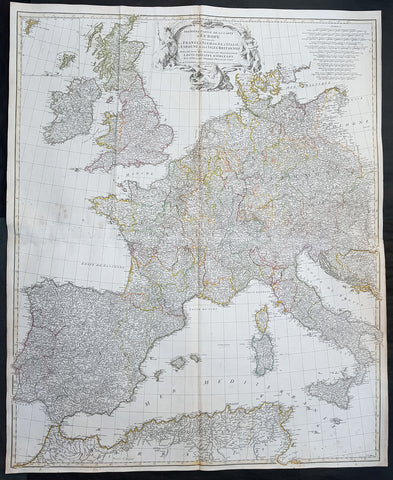
1754 D Anville Large Original Antique Map of Western Europe British Isles - Rare
- Title : Premiere Partie De La Carte D Europe...MDCCLIV
- Size: 39 1/2in x 33in (1.03m x 840mm)
- Ref #: 92307
- Date : 1754
- Condition: (A+) Fine Condition
Description:
This large finely engraved scarce and highly detailed original antique map of contemporary Western Europe and the British Isles was engraved by Guillaume de la Haye in 1754 - dated in the tile cartouche - and was published in Jean-Baptiste Bourguinon D\'Anville\'s large elephant folio atlas Atlas Generale.
General Definitions:
Paper thickness and quality: - Heavy and stable
Paper color : - off white
Age of map color: - Original
Colors used: - Pink, yellow, green, blue
General color appearance: - Authentic
Paper size: - 39 1/2in x 33in (1.03m x 840mm)
Plate size: - 38in x 32in (970mm x 815mm)
Margins: - Min 1/2in (12mm)
Imperfections:
Margins: - None
Plate area: - Light spotting, folds as issued
Verso: - Light spotting, folds as issued
Background:
Fantastic historical map showing the fragmented political borders,hand coloured, of Western Europe in the mid 18th century from Poland to France and North Africa, including the British Isles.
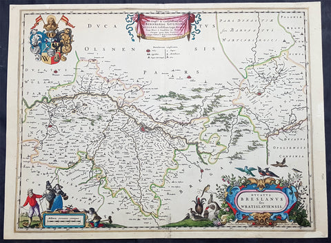
1670 Joan Blaeu Antique Map City & Region Breslau, Wroclaw, Silesia Lower Poland
- Title : Ducatus Breslanus sive Wratislaviensis
- Ref #: 93427
- Size: 23 1/2in x 17in (595mm x 435mm)
- Date : 1670
- Condition: (A+) Fine Condition
Description:
This beautifully hand coloured original copper-plate engraved antique, rare map of the City & Region Breslau, Wroclaw, Silesia Lower Poland, was published in Joan Blaeu greatest publication, the first 1670 German edition of Atlas Major,.
As this map was only published over a 10 year period, as most of the plates were destroyed in the disasterous 1672 fire that wiped out the Blaeu publishing house, this map is extremely rare especially with original hand colour, such as this map.
General Definitions:
Paper thickness and quality: - Heavy and stable
Paper color : - off white
Age of map color: - Original
Colors used: - Yellow, green, blue, pink
General color appearance: - Authentic
Paper size: - 23 1/2in x 17in (595mm x 435mm)
Plate size: - 21in x 16 1/2in (535mm x 420mm)
Margins: - Min 1/2in (12mm)
Imperfections:
Margins: - None
Plate area: - None
Verso: - None
Background:
Wrocław is a city in western Poland and the largest city in the historical region of Silesia. It lies on the banks of the River Oder in the Silesian Lowlands of Central Europe.
Wrocław is the historical capital of Silesia and Lower Silesia. Today, it is the capital of the Lower Silesian Voivodeship. The history of the city dates back over a thousand years; at various times, it has been part of the Kingdom of Poland, the Kingdom of Bohemia, the Kingdom of Hungary, the Habsburg Monarchy of Austria, the Kingdom of Prussia and Germany. Wrocław became part of Poland again in 1945 as part of the so-called Recovered Territories as a result of the border changes after the Second World War.
1720 John Senex Large Antique Map of France in Provinces
- Title : France corrected from ye Observations by the Royal Academy Society at Paris by John Senex
- Size: 41 1/2in x 26 1/2in (1.040m x 660mm)
- Condition: (A) Very Good Condition
- Date : 1878
- Ref #: 24903
Description:
This large hand coloured original copper plate engraved antique map of France by John Senex, was published in the 1720 edition of his Elephant Folio Atlas.
This map is in VG condition. These large scale maps are scarce due mainly to their size, with damage and loss over time inevitable.
General Definitions:
Paper thickness and quality: - Heavy and stable
Paper color : - off white
Age of map color: - Original
Colors used: - Yellow, green, blue, pink
General color appearance: - Authentic
Paper size: - 41 1/2in x 26 1/2in (1.040m x 660mm)
Plate size: - 36in x 24 1/2in (915mm x 615mm)
Margins: - Min 1/2in (12mm)
Imperfections:
Margins: - Light chipping to margin edges
Plate area: - Discouloration to bottom centerfold
Verso: - None
Background:
The history of French cartography can be traced to developments in the Middle Ages. This period was marked by improvements in measuring instruments and also by an upgrade of work in registers of all types.
The first map of France was drawn by Oronce Finé and printed in woodcuts in 1525. It testifies to the will of the political power to mark its presence on the territory; to affirm, to build limits, borders, to arrange its territory, and to consolidate the internal economic markets.
In the sixteenth century, Dieppe appeared as an important school of cartography. Pierre Desceliers allowed the realization of many maps. At the same time, the Portolan maps of the Portuguese sailors had the most recent knowledge obtained by the Dieppois sailors in their exploration of Canada.
Then, cartography progressed more and more, through the development of new techniques and by the will of the political powers to control their territories. Very powerful companies testify support to some of the cartographic missions at the end of the nineteenth century.
There were two decisive stages in cartography. One was determining longitude and latitude. Florence Trystram, 2001, the lawsuit of the stars is an account of the research of three French scientists that was done in South America, 1735-1771.
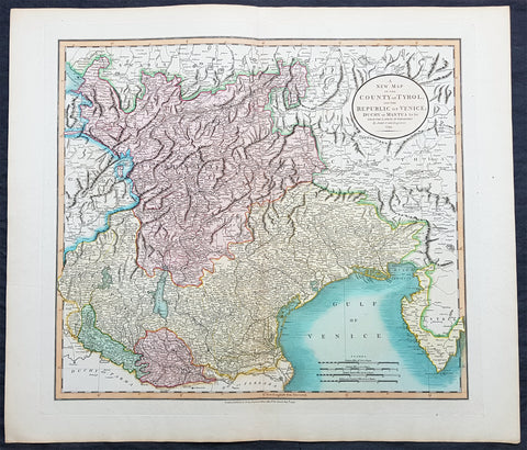
1799 John Cary Large Antique Map The Republic of Venice w/ Tyrol & Mantua Italy
- Title : A New Map of The County of Tyrol and the Republic of Venice Duchy of Mantua by John Cary Engraver 1799....Published by J Cary Engraver & Mapseller No. 181 Strand Aug 1st 1799
- Ref #: 72779
- Size: 25in x 21 1/2in (635mm x 545mm)
- Date : 1799
- Condition: (A+) Fine Condition
Description:
This large magnificently hand coloured original copper-plate engraved antique map of The Republic of Venice & the County of Tyrol, Cremona & Mantua was engraved & published by John Cary in 1799 - the date is engraved in the title cartouche - and was published in the 1808 edition of Carys New Universal Atlas.(Ref Tooley M&B)
General Definitions:
Paper thickness and quality: - Heavy and stable
Paper color : - off white
Age of map color: - Original
Colors used: - Yellow, green, blue, pink
General color appearance: - Authentic
Paper size: - 25in x 21 1/2in (635mm x 545mm)
Plate size: - 22in x 20in (560mm x 510mm)
Margins: - Min 1/2in (12mm)
Imperfections:
Margins: - None
Plate area: - None
Verso: - None
Background:
The Republic of Venice traditionally known as La Serenissima - English: Most Serene Republic of Venice was a sovereign state and maritime republic in northeastern Italy, which existed for a millennium between the 8th century and the 18th century. It was based in the lagoon communities of the historically prosperous city of Venice, and was a leading European economic and trading power during the Middle Ages and the Renaissance.
The Venetian city state was founded as a safe haven for the people escaping persecution in mainland Europe after the decline of the Roman Empire. In its early years, it prospered on the salt trade. In subsequent centuries, the city state established a thalassocracy. It dominated trade on the Mediterranean Sea, including commerce between Europe and North Africa, as well as Asia. The Venetian navy was used in the Crusades, most notably in the Fourth Crusade. Venice achieved territorial conquests along the Adriatic Sea. The city became home to an extremely wealthy merchant class, who patronized renowned art and architecture along the city\'s lagoons. Venetian merchants were influential financiers in Europe. The city was also the birthplace of great European explorers, especially Marco Polo, as well as Baroque composers such as Vivaldi and Benedetto Marcello.
The republic was ruled by the Doge, who was elected by members of the Great Council of Venice, the city-state\'s parliament. The ruling class was an oligarchy of merchants and aristocrats. Venice and other Italian maritime republics played a key role in fostering capitalism. Venetian citizens generally supported the system of governance. The city-state enforced strict laws and employed ruthless tactics in its prisons.
The opening of new trade routes to the Americas and the East Indies via the Atlantic Ocean marked the beginning of Venice\'s decline as a powerful maritime republic. The city state suffered defeats from the navy of the Ottoman Empire. In 1797, the republic was plundered by retreating Austrian and then French forces, following an invasion by Napoleon Bonaparte, and the Republic of Venice was split into the Austrian Venetian Province, the Cisalpine Republic, a French client state, and the Ionian French departments of Greece. Venice then became a part of a unified Italy in the 19th century.
1639 Henricus Hondius Antique Map of France
- Title : Galliae supera omnes in hac...auctore Henrico Hondio
- Date : 1639
- Size: 22 1/2in x 18in (570mm x 455mm)
- Condition: (A+) Fine Condition
- Ref: 17039
Description:
This original hand coloured copper plate engraved antique map of France was published by Henricus Hondius & Jan Jansson in the 1639 French edition of Gerard Mercators Atlas.
General Definitions:
Paper thickness and quality: - Heavy and stable
Paper color : - off white
Age of map color: - Original
Colors used: - Pink, blue, green, yellow
General color appearance: - Authentic
Paper size: - 22 1/2in x 18in (570mm x 455mm)
Plate size: - 19 1/2in x 14 1/2in (500mm x 375mm)
Margins: - Min 1in (25mm)
Imperfections:
Margins: - None
Plate area: - None
Verso: - None
1574 Munster Large Antique Print View of The City of Wormbs, Germany
- Title : Die Statt Wormbs
- Ref #: 22670
- Size: 27in x 13in (685mm x 330mm)
- Date : 1574
- Condition: (A) Very Good Condition
Description:
This large folding original antique print a View of the important German city ofWormbs, south of Hamburg was published in the 1574 release of Sebastian MunstersCosmographia published by Sebastian Petri, Basle.
(This is a reasonably scarce map as the large fold out maps in Cosmographia were easily damaged and lost)
Background: For a variety of reasons town plans were comparatively latecomers in the long history of cartography. Few cities in Europe in the middle ages had more than 20,00 inhabitants and even London in the late Elizabethan period had only 100-150,000 people which in itself was probably 10 times that of any other English city. The Nuremberg Chronicle in 1493 included one of the first town views of Jerusalem, thereafter, for most of the sixteenth century, German cartographers led the way in producing town plans in a modern sense. In 1544 Sebastian Munster issued in Basle his Cosmographia containing roughly sixty-six plans and views, some in the plan form, but many in the old panorama or birds eye view. (Ref: Tooley; M&B)
General Description:
Paper thickness and quality: - Heavy and stable
Paper color: - off white
Age of map color: - Later
Colors used: - Green, blue, yellow, pink
General color appearance: - Authentic
Paper size: - 27in x 13in (685mm x 330mm)
Plate size: - 25in x 10in (635 x 255m)
Margins: - 1/2in (12mm)
Imperfections:
Margins: - Light soiling
Plate area: -Folds re-joined small loss, light soiling, light creasing
Verso: - Light soiling, colour show through, half the map backed in archival material
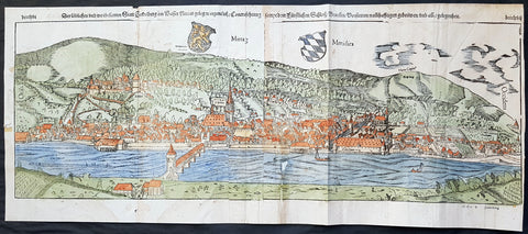
1574 Sebastian Munster Large Antique Birds Eye City View of Heidelberg, Germany
- Title : Die Statt Heidelberg
- Size: 29in x 13in (740mm x 330mm)
- Ref #: 22692
- Date : 1574
- Condition: (B) Good Condition
Description:
This large hand coloured, original antique wood-block engraved birds-eye view of the German City of Heidelberg was published in the 1574 edition of Sebastian Munsters Cosmographia.
There were 2 large folding views in Cosmographia, both German cities, Wormbs and Heidelberg. As these were large folding views they were easily torn and damaged and so quiet rare, especially from the earlier editions.
The Cosmographia or Cosmography was first published in 1544 and is the earliest German-language description of the world.
It had numerous editions in different languages including Latin, French (translated by François de Belleforest), Italian, English, and Czech. The last German edition was published in 1628. The Cosmographia was one of the most successful and popular books of the 16th century and passed through 24 editions in 100 years. This success was due to the notable woodcuts (some by Hans Holbein the Younger, Urs Graf, Hans Rudolph Manuel Deutsch, and David Kandel). It was most important in reviving geography in 16th-century Europe. Among the notable maps within Cosmographia is the map Die Newe Welt oder Inseln, which is credited as the first map to show the American continents as geographically unique.
Munsters earlier geographic works were Germania descriptio (1530) and Mappa Europae (1536). In 1540, he published a Latin edition of Ptolemys Geographia, with numerous illustrations.
General Definitions:
Paper thickness and quality: - Heavy and stable
Paper color : - off white
Age of map color: - Original
Colors used: - Orange, yellow, blue, red
General color appearance: - Authentic
Paper size: - 29in x 13in (740mm x 330mm)
Plate size: - 29in x 13in (740mm x 330mm)
Margins: - Min 1/2in (12mm)
Imperfections:
Margins: - Left margin cropped to plate-mark, light age toning repair to right & bottom margins
Plate area: - Left plate small loss along centrer-fold, light spotting & creasing
Verso: - Left plate backed onto contemporary paper
Background:
Heidelberg is a college town in Baden-Wurttemberg situated on the river Neckar in south-west Germany.
Located about 78 km south of Frankfurt, Heidelberg is the fifth-largest city in the German state.
Founded in 1386, Heidelberg University is Germany\'s oldest and one of Europe\'s most reputable universities.
Heidelberg University played a leading part in the era of humanism and the Reformation, and the conflict between Lutheranism and Calvinism, in the 15th and 16th centuries. Heidelberg\'s library, founded in 1421, is the oldest existing public library in Germany. In April 1518, a few months after proclaiming his 95 Theses, Martin Luther was received in Heidelberg, to defend them. In 1537, the castle located higher up the mountain was destroyed by a gunpowder explosion. The duke\'s palace was built at the site of the lower castle.
The siege of Heidelberg 1622
Elector Frederick III, sovereign of the Electoral Palatinate from 1559 to 1576, commissioned the composition of a new Catechism for his territory. While the catechism\'s introduction credits the entire theological faculty here (at the University of Heidelberg) and all the superintendents and prominent servants of the church for the composition of the catechism, Zacharius Ursinus is commonly regarded as the catechism\'s principal author. Caspar Olevianus (1536–1587) was formerly asserted as a co-author of the document, though this theory has been largely discarded by modern scholarship. Johann Sylvan, Adam Neuser, Johannes Willing, Thomas Erastus, Michael Diller, Johannes Brunner, Tilemann Mumius, Petrus Macheropoeus, Johannes Eisenmenger, Immanuel Tremellius and Pierre Boquin are all likely to have contributed to the Catechism in some way. Frederick himself wrote the preface to the Catechism and closely oversaw its composition and publication. Frederick, who was officially Lutheran but had strong Reformed leanings, wanted to even out the religious situation of his highly Lutheran territory within the primarily Catholic Holy Roman Empire. The Council of Trent had just concluded with its conclusions and decrees against the Protestant faiths, and the Peace of Augsburg had only granted toleration for Lutheranism within the empire where the ruler was Lutheran. One of the aims of the catechism was to counteract the teachings of the Roman Catholic Church as well as Anabaptists and \"strict\" Gnesio-Lutherans like Tilemann Heshusius and Matthias Flacius, who were resisting Frederick\'s Reformed influences, particularly on the matter of Eucharist (the Lord\'s Supper). The Catechism-based each of its statements on biblical proof-texts, and Frederick himself would defend it as biblical, not reformed, at the 1566 Diet of Augsburg when he was called to answer to charges of violating the Peace of Augsburg. This was the Heidelberg Catechism, officially called the Catechism, or Christian Instruction, according to the Usages of the Churches and Schools of the Electoral Palatinate.
In November 1619, the royal crown of Bohemia was offered to the Elector, Frederick V. (He was married to Elizabeth, eldest daughter of James VI and I of Scotland and England, respectively.) Frederick became known as the Winter King, as he reigned for only one winter before the Imperial House of Habsburg regained the crown by force. His overthrow in 1621 marked the beginning of the Thirty Years War. In 1622, after a siege of two months, the armies of the Catholic League, commanded by Johann Tserclaes, Count of Tilly, captured the town. Tilly gave the famous Bibliotheca Palatina from the Church of the Holy Spirit to the Pope as a present. The Catholic Bavarian branch of the House of Wittelsbach gained control over the Palatinate and the title of Prince-Elector. In 1648, at the end of the war, Frederick Vs son Charles I Louis, Elector Palatine, was able to recover his titles and lands.
In late 1634 Imperialist forces attempted to take back the city, as the Swedish army had conquered it. They quickly took the city, but were unable to take the castle. As they prepared to blow up its fortifications with gunpowder the French army arrived, 30,000 men strong, led by Urbain de Maillé-Brézé, who had fought in many battles and participated in the Siege of La Rochelle (1627–1628), and Jacques-Nompar de Caumont, duc de La Force. They ended the siege and drove off the Catholic forces.
To strengthen his dynasty, Charles I Louis arranged the marriage of his daughter Liselotte to Philip I, Duke of Orléans, brother of Louis XIV, king of France. In 1685, after the death of Charles Louis\' son, Elector Charles II, Louis XIV laid claim to his sister-in-laws inheritance. The Germans rejected the claim, in part because of religious differences between local Protestants and the French Catholics, as the Protestant Reformation had divided the peoples of Europe. The War of the Grand Alliance ensued. In 1689, French troops took the town and castle, bringing nearly total destruction to the area in 1693. As a result of the destruction due to repeated French invasions related to the War of the Palatinate Succession coupled with severe winters, thousands of Protestant German Palatines emigrated from the lower Palatinate in the early 18th century. They fled to other European cities and especially to London (where the refugees were called the poor Palatines). In sympathy for the Protestants, in 1709–1710, Queen Anne\'s government arranged transport for nearly 6,000 Palatines to New York. Others were transported to Pennsylvania, and to South Carolina. They worked their passage and later settled in the English colonies there.
In 1720, after assigning a major church for exclusively Catholic use, religious conflicts with the mostly Protestant inhabitants of Heidelberg caused the Roman Catholic Prince-Elector Charles III Philip to transfer his residence to nearby Mannheim. The court remained there until the Elector Charles Theodore became Elector of Bavaria in 1777 and established his court in Munich. In 1742, Elector Charles Theodore began rebuilding the Palace. In 1764, a lightning bolt destroyed other palace buildings during reconstruction, causing the work to be discontinued.
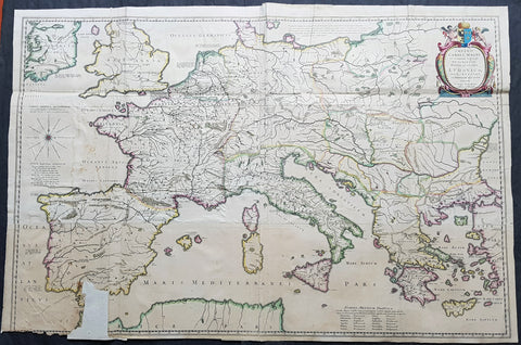
1634 Joan Blaeu Large Rare Antique Map of Europe under Charlemagne I, 8th Century
- Title : Imperii Caroli Magni et vicinarum regionum Descriptio Dedieata et inferipta Ludovico... Petro Bertio.
- Size: 39 1/2in x 26 1/2in (1.00mm x 670mm)
- Condition: (B) Good Condition
- Date : 1634
- Ref #: 70607
Description:
This large superbly hand coloured original copper plate engraved, 4 x sheet, antique map of Europe, as it was under Charlemagne I, was originally published by the 16th century cartographer Petrus Bertius and later re-engraved and published in the 1634 German edition of Joan Blaeus Atlas Novus.
The map has been damaged at the bottom left sheet, with image missing. As this is a large folding map, the folds, sometime in the past, have been re-enforced and refolded.
This map is rare and hard to find and in fine condition can sell over $1500US.
A large four sheet historical map showing the empire of Charlemagne, aka Carolus Magnus, aka Charles the Great. Charlemagne ruled in the 8th century and is regarded as the founding father of both France and Germany. Blaeu credits Petrus Bertius for the cartography. Bertius (1565-1629) was a professor of mathematics and librarian at Leyden University. He was also cartographer and a prolific writer on historical and theological subjects. The map shows the majority of Europe, from southeastern Ireland south to Gibraltar and westward to Germany and Greece.
General Definitions:
Paper thickness and quality: - Heavy and stable
Paper color : - off white
Age of map color: - Original
Colors used: - Yellow, green, blue, pink
General color appearance: - Authentic
Paper size: - 39 1/2in x 26 1/2in (1.00m x 670mm)
Plate size: - 39in x 26in (980mm x 660mm)
Margins: - Min 0in (0mm)
Imperfections:
Margins: - Bottom left corner margins lost
Plate area: - Folds as issued, bottom 4in x 2in section missing. Light soiling
Verso: - Folds re-enforced on verso
Background:
Charlemagne 742 - 814, numbered Charles I, was king of the Franks from 768, king of the Lombards from 774, and emperor of the Romans from 800. He united much of western and central Europe during the Early Middle Ages. He was the first recognised emperor to rule from western Europe since the fall of the Western Roman Empire three centuries earlier. The expanded Frankish state that Charlemagne founded is called the Carolingian Empire. He was later canonized by Antipope Paschal III.
Charlemagne was the eldest son of Pepin the Short and Bertrada of Laon, born before their canonical marriage. He became king in 768 following his fathers death, initially as co-ruler with his brother Carloman I. Carlomans sudden death in December 771 under unexplained circumstances left Charlemagne as the sole ruler of the Frankish Kingdom. He continued his fathers policy towards the papacy and became its protector, removing the Lombards from power in northern Italy and leading an incursion into Muslim Spain. He campaigned against the Saxons to his east, Christianizing them upon penalty of death and leading to events such as the Massacre of Verden. He reached the height of his power in 800 when he was crowned Emperor of the Romans by Pope Leo III on Christmas Day at Romes Old St. Peters Basilica.
Charlemagne has been called the Father of Europe (Pater Europae), as he united most of Western Europe for the first time since the classical era of the Roman Empire and united parts of Europe that had never been under Frankish or Roman rule. His rule spurred the Carolingian Renaissance, a period of energetic cultural and intellectual activity within the Western Church. Emperors of the Holy Roman Empire considered themselves successors of Charlemagne, as did the French and German monarchs. However, the Eastern Orthodox Church views Charlemagne more controversially, labelling as heterodox his support of the filioque and the Popes recognition of him as legitimate Roman Emperor rather than Irene of Athens of the Byzantine Empire. These and other machinations led to the eventual split of Rome and Constantinople in the Great Schism of 1054.
Charlemagne died in 814, having ruled as emperor for almost 14 years and as king for almost 46 years. He was laid to rest in his imperial capital city of Aachen. He married at least four times and had three legitimate sons, but only his son Louis the Pious survived to succeed him.
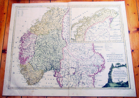
1796 Von Reilly Very Large Antique Map Norway, Sweden & Lapland - Scandinavia
- Title : Karte von dem Konigreiche Norwegen...Franz Von Reilly...Wein 1796
- Ref #: 40441
- Size: 31 1/2in x 26in (800mm x 600mm)
- Date : 1796
- Condition: (A+) Fine Condition
Description:
This large copper-plate engraved original antique map of Norway with parts of Sweden - with an inset map of Lapland - was engraved in 1796 - the date is engraved at the foot of the map - and was published by Franz Joseph Von Reilly in his 1794-96 Grosser Deutscher Atlas.
Von Reilly was a Viennese art dealer who in his early twenties turned to map publishing, and between 1789 and 1806 produced a total of 830 maps. His Schauplatz...der Welt (World Atlas) in fac t covered only maps of Europe, whilst theGrosser Deutscher Atlas also included maps of other continents and was therefore the first World Atlas produced by an Austrian. (Ref: M&B; Tooley)
General Description:
Paper thickness and quality: - Heavy & stable
Paper color: - White
Age of map color: - Original
Colors used: - Yellow, pink, green
General color appearance: - Authentic
Paper size: - 31 1/2in x 26in (800mm x 600mm)
Plate size: - 30in x 24in (760mm x 610mm)
Margins: - Min 1in (25mm)
Imperfections:
Margins: - None
Plate area: - None
Verso: - None
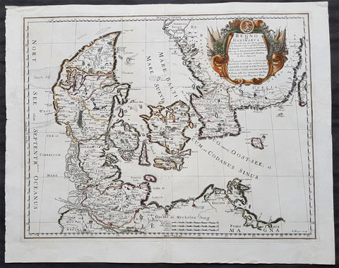
1677 De Rossi Large Original Antique Map of Denmark & Sweden, Schleswig Holstein
- Title : Regno di Danimarca Diuiso nelle Sue due Iutlandie Cioe settentrionale in quattro Diocesi Et Australe, e` il Ducato di...Gio Giacomo De Rossi....L Anno 1677
- Date : 1677
- Size: 22 1/2in x 18in (575mm x 460mm)
- Ref #: 50610
- Condition: (A) Very Good Condition
Description:
A beautiful and quite scarce original 1677 antique map of Denmark and southern Sweden, was engraved in 1677 - dated in the title - and was published in the 1692 edition of de Rossi's world atlas Mercurio Geografico
General Definitions:
Paper thickness and quality: - Heavy and stable
Paper color : - off white
Age of map color: - Early
Colors used: - Yellow, green, blue, pink
General color appearance: - Authentic
Paper size: - 22 1/2in x 18in (575mm x 460mm)
Plate size: - 20 1/2in x 16in (420mm x 405mm)
Margins: - Min 1in (25mm)
Imperfections:
Margins: - Professional repairs to top & bottom margins
Plate area: - Professional repairs to centerfold
Verso: - Repairs as noted
Background:
Before the fifteenth century the people of Southern Europe had little geographical knowledge of the Scandinavian World except from sketchy detail shown in the Catalan Atlas (1375) and on a number of " portolani" embracing Denmark and the southern tip of Norway. It was not until 1427 that a manuscript map prepared about that time by Claudius Clavus (b.1388) a Dane who spent some time in Rome, made available to scholars a tolerable outline of the northern countries and Greenland. That was to remain the best map available for the rest of the century and it was used as the basis for maps of Scandinavia in early printed editions of Ptolemy. Others by Nicolaus Cusanus (1491) and Ehrhard Etzlaub (c. 1492) followed but, needless to say, these are extremely rare; even the later maps by Olaus Magnus and Marcus Jordan, where they have survived at all , are known only by a very few examples. In fact, apart from the rare appearance of an early Ptolemy map, the oldest of Scandinavia which a collector is likely to find are those of Munster's Cosmograhy first published in 1544. In the following centuries the few maps and charts complied in Scandinavia were usually published in Amsterdam, Antwerp, Paris or Nuremberg, the most important maps often being incorporated in the major Dutch, French & German Atlases. (Ref: Tooley; M&B)
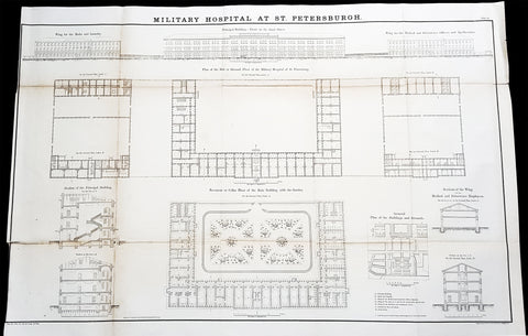
1856 Delafield Antique Architectural Plan SM Kirov Medical Academy St Petersburg
- Title : Military Hospital at St Petersburg
- Condition: (A+) Fine Condition
- Ref: 90139
- Size: 36in x 24in (915mm x 610mm)
Description:
This very large original lithograph print, an architectural plan of the S.M. Kirov Military Medical Academy in St Petersburg, Russia - during the time of the Crimean War and just prior to the American Civil War - was engraved by John T Bowen & co. of Philadelphia and was published in the 1856 edition of Captain Richard Delafields Report on the Art of War in Europe in 1854, 1855, and 1856.
In early 1855, Captain Richard Delafield was appointed by the Secretary of War, Jefferson Davis, a head of the board of officers, later called The Delafield Commission, and sent to Europe to study the European military. The board included Captain George B. McClellan and Major Alfred Mordecai. They inspected the state of the military in Great Britain, Germany, the Austrian Empire, France, Belgium, and Russia, and served as military observers during the Crimean War. After his return in April 1856, Delafield submitted a report which was later published as a book by Congress, Report on the Art of War in Europe in 1854, 1855, and 1856. The book was suppressed during the American Civil War due to fears that it would be instructive to Confederate engineers as it contained multiple drawings and descriptions of military fortifications.
General Definitions:
Paper thickness and quality: - Light and stable
Paper color : - off white
Age of map color: -
Colors used: -
General color appearance: -
Paper size: - 36in x 24in (915mm x 610mm)
Plate size: - 36in x 24in (915mm x 610mm)
Margins: - Min 1/2in (12mm)
Imperfections:
Margins: - None
Plate area: - Folds as issued
Verso: - Folds re-enforced with archival tape
Background:
The S. M. Kirov Military Medical Academy (Военно-медицинская академия имени С. М. Кирова) is the oldest school of military medicine in Saint Petersburg and the Russian Federation. Senior medical staff are trained for the Armed Forces and conduct research in military medical services.
The origins of S.M. Kirov Military Medical Academy go back to the years of Peter the Great. In 1715 by the Tsars order the Admiralty Hospital in the Vyborg Side of Saint Petersburg was founded. In 1717 next to in the Land Military Hospital was opened. Since 1773 surgical schools attached to both hospitals were operating. In 1786 those schools were consolidated into the Main Medical College. It became the principal training center for army and fleet physicians.
Unofficially, the year 1714 is considered the foundation year of the academy. The Medical and Surgical Academy was established by the order of Emperor Paul I of 18/29 December 1798 on the initiative of Baron Alexei Vasilyev, General Director of the Medical College. At the same time a Neoclassical building for the Academy was designed by Antonio Porta. It was decorated with a set of panel paintings by Giuseppe Bernasconi.
Ranked as one of the best educational institutions in the Russian Empire, it was known as the Imperial Medical and Surgical Academy from 1808. According to the order of Emperor Alexander I, a member of the Medical and Surgical Academy had the rights, liabilities, and benefits of a member of the Academy of Sciences.
Sir James Wylie, a Scottish baronet, managed the academy between 1808 and 1838. His contributions have been commemorated with a monument which stood in front of the academy until the October Revolution. The monument was designed in 1859 by David Jensen. It was later relocated and replaced with a statue of Hygieia.
In 19th century the Imperial Medical and Surgical Academy played a major role in the development of Russian natural science and medicine. In 1840 — 1856 one of its professors was Nikolay Pirogov, considered the founder of field surgery.
Since 1861 Sergey Botkin, one of Pirogovs disciples, worked at the Academy. He is considered one of the founders of modern Russian medical science and education. Botkin introduced triage, pathological anatomy, and post mortem diagnostics into Russian medical practice.
In 1881 the Academys official name was changed into the Imperial Military Medical Academy. In the late 19th century, its physiology laboratory, founded by Ivan Sechenov, was at the forefront of medical research. Ivan Romanovich Tarkhanov conducted some important experiments there.
In 1890 — 1901 the Academys President was Viktor Pashutin, one of the founders of the pathophysiologic school in Russia and of pathophysiology as an independent scientific discipline.
The Nobel-prize winning physiologist Ivan Pavlov graduated from the Academy in 1879 with Gold Medal award. Since 1895 he headed Department of Physiology at the Academy for three decades.
In 1904 — 1924 Nikolai Kravkov, the founder of Russian national school of pharmacologists, headed the Academys Department of Pharmacology.
In 1903 — 1936 one of the Academys professors was Sergey Fedorov, the founder of the largest national school of surgery and «the father of Russian urology».
The academy was also among the pioneers of medical education for women, launching the courses for nurse-midwives in 1872. Nadezhda Suslova, the first female physician in Russia, attended Sechenovs classes at the academy. A school of gymnastics (now the Military Institute of Physical Culture) was launched in 1909.
Delafield, Richard Major General 1798 - 1873
Delafield was a United States Army officer for 52 years. He served as superintendent of the United States Military Academy for 12 years. At the start of the American Civil War, then Colonel Delafield helped equip and send volunteers from New York to the Union Army. He also was in command of defences around New York harbor from 1861 to April 1864. On April 22, 1864, he was promoted to Brigadier General in the Regular Army of the United States and Chief of Engineers. On March 8, 1866, President Andrew Johnson nominated Delafield for appointment to the grade of brevet major general in the Regular Army, to rank from March 13, 1865, and the United States Senate confirmed the appointment on May 4, 1866, reconfirmed due to a technicality on July 14, 1866. He retired from the US Army on August 8, 1866. He later served on two commissions relating to improvements to Boston Harbor and to lighthouses. He also served as a regent of the Smithsonian Institution.
Delafield served as assistant engineer in the construction of Hampton Roads defences from 1819–1824 and was in charge of fortifications and surveys in the Mississippi River delta area in 1824-1832. While superintendent of repair work on the Cumberland Road east of the Ohio River, he designed and built Dunlaps Creek Bridge in Brownsville, Pennsylvania, the first cast-iron tubular-arch bridge in the United States. Commissioned a major of engineers in July 1838, he was appointed superintendent of the Military Academy after the fire of 1838 and served till 1845. He designed the new buildings and the new cadet uniform that first displayed the castle insignia. He superintended the construction of coast defences for New York Harbor from 1846 to 1855.
In the beginning of 1855, Delafield was appointed by the Secretary of War, Jefferson Davis a head of the board of officers, later called The Delafield Commission, and sent to Europe to study the European military. The board included Captain George B. McClellan and Major Alfred Mordecai. They inspected the state of the military in Great Britain, Germany, the Austrian Empire, France, Belgium, and Russia, and served as military observers during the Crimean War. After his return in April 1856, Delafield submitted a report which was later published as a book by Congress, Report on the Art of War in Europe in 1854, 1855, and 1856. The book was suppressed during the American Civil War due to fears that it would be instructive to Confederate engineers as it contained multiple drawings and descriptions of military fortifications.
Delafield served as superintendent of the Military Academy again in 1856-1861. In January 1861, he was succeeded by Captain Pierre G. T. Beauregard, who was dismissed shortly after Beauregards home state of Louisiana seceded from the Union, and Delafield returned as superintendent serving until March 1, 1861. In the beginning of the Civil War he advised the governor of New York Edwin D. Morgan during the volunteer force creation. Then, in 1861–1864, he was put in charge of New York Harbor defences, including Governors Island and Fort at Sandy Hook. On May 19, 1864, he was commissioned a brigadier-general after replacing Joseph Gilbert Totten, who had died, as the Chief of Engineers, United States Army Corps of Engineers, on April 22, 1864. He stayed in charge of the Bureau of Engineers of the War Department until his retirement on August 8, 1866. On March 8, 1866, President Andrew Johnson nominated Delafield for appointment to the grade of brevet major general in the Regular Army of the United States, to rank from March 13, 1865, and the United States Senate confirmed the appointment on May 4, 1866 and reconfirmed it due to a technicality on July 14, 1866.After retirement Delafield served as a regent of the Smithsonian Institution and a member of the Lighthouse Board. He died in Washington, D.C. on November 5, 1873.
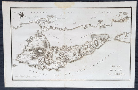
1802 J B Lechevalier & Pierre Tardieu Large Antique Map of Corfu, Greece
- Title : Plan De L Ile De Corfou
- Date : 1802
- Condition: (A+) Fine Condition
- Ref: 50669-1
- Size: 21in x 14in (535mm x 355mm)
Description:
This original copper-plate engraved antique map of the Greek Island of Corfu was engraved by Pierre Tardieu and was published in the 1802 edition of Jean-Baptiste Lechevaliers of Voyage de la Troade, fait dans les années 1785 et 1786
General Definitions:
Paper thickness and quality: - Heavy and stable
Paper color : - off white
Age of map color: -
Colors used: -
General color appearance: -
Paper size: - 21in x 14in (535mm x 355mm)
Plate size: - 20 1/2in x 13in (520mm x 335mm)
Margins: - Min 1/2in (12mm)
Imperfections:
Margins: - Light soiling
Plate area: - Light soiling
Verso: - Light soiling
Background:
Corfu or Kerkyra is a Greek island in the Ionian Sea. It is the second largest of the Ionian Islands and, including its small satellite islands, forms the north-westernmost part of Greece. The island is part of the Corfu regional unit, and is administered as a single municipality, which also includes the smaller islands of Ereikoussa, Mathraki and Othonoi. The municipality has an area of 610,9 km2, the island proper 592,8 km2. The principal city of the island and seat of the municipality (pop. 32,095) is also named Corfu. Corfu is home to the Ionian University.
The island is bound up with the history of Greece from the beginnings of Greek mythology. Its history is full of battles and conquests. Ancient Korkyra took part in the Battle of Sybota which was a catalyst for the Peloponnesian War, and, according to Thucydides, the largest naval battle between Greek city states until that time. Thucydides also reports that Korkyra was one of the three great naval powers of fifth century BC Greece, along with Athens and Corinth. Medieval castles punctuating strategic locations across the island are a legacy of struggles in the Middle Ages against invasions by pirates and the Ottomans. Two of these castles enclose its capital, which is the only city in Greece to be surrounded in such a way. As a result, Corfu\'s capital has been officially declared a Kastropolis (castle city) by the Greek government. From medieval times and into the 17th century, the island, having successfully repulsed the Ottomans during several sieges, was recognised as a bulwark of the European States against the Ottoman Empire and became one of the most fortified places in Europe. The fortifications of the island were used by the Venetians to defend against Ottoman intrusion into the Adriatic. Corfu eventually fell under British rule following the Napoleonic Wars. Corfu was eventually ceded by the British Empire along with the remaining islands of the United States of the Ionian Islands, and unification with modern Greece was concluded in 1864 under the Treaty of London.
Jean-Baptiste Lechevalier was the secretary of the Ambassador of France in Constantinople. In the year 1788 he visited the plain of Troy, and was enthusiastically in favour of the theory that the site of Homers Troy was to be found at the village of Bunarbashi. His publication about Troy Voyage de la Troade.....was first published in 1799.
The Troad, also known as Troas, is the historical name of the Biga peninsula (Biga Yarımadası, Τρωάς) in the northwestern part of Anatolia, Turkey. This region now is part of the Çanakkale province of Turkey. Bounded by the Dardanelles to the northwest, by the Aegean Sea to the west and separated from the rest of Anatolia by the massif that forms Mount Ida, the Troad is drained by two main rivers, the Scamander (Karamenderes) and the Simois, which join at the area containing the ruins of Troy. Grenikos, Kebren, Simoeis, Rhesos, Rhodios, Heptaporos and Aisepos were seven rivers of the Troad and the names of the river gods that inhabited each river.
Troy (Ancient Greek: Τροία, Troia or Τροίας, Troias, Truva or Troya) was a city in the far northwest of the region known in late Classical antiquity as Asia Minor, now known as Anatolia in modern Turkey, just south of the southwest mouth of the Dardanelles strait and northwest of Mount Ida. The present-day location is known as Hisarlik. It was the setting of the Trojan War described in the Greek Epic Cycle, in particular in the Iliad, one of the two epic poems attributed to Homer. Metrical evidence from the Iliad and the Odyssey suggests that the name λιον (Ilion) formerly began with a digamma: Ϝίλιον (Wilion); this is also supported by the Hittite name for what is thought to be the same city, Wilusa.
A new capital called Ilium (from Greek: λιον, Ilion) was founded on the site in the reign of the Roman Emperor Augustus. It flourished until the establishment of Constantinople, became a bishopric and declined gradually in the Byzantine era, but is now a Latin Catholic titular see.
In 1865, English archaeologist Frank Calvert excavated trial trenches in a field he had bought from a local farmer at Hisarlik, and in 1868, Heinrich Schliemann, a wealthy German businessman and archaeologist, also began excavating in the area after a chance meeting with Calvert in Çanakkale. These excavations revealed several cities built in succession. Schliemann was at first skeptical about the identification of Hisarlik with Troy, but was persuaded by Calvert and took over Calverts excavations on the eastern half of the Hisarlik site, which was on Calvert\'s property. Troy VII has been identified with the city called Wilusa by the Hittites (the probable origin of the Greek λιον) and is generally (but not conclusively) identified with Homeric Troy.
Today, the hill at Hisarlik has given its name to a small village near the ruins, which supports the tourist trade visiting the Troia archaeological site. It lies within the province of Çanakkale, some 30 km south-west of the provincial capital, also called Çanakkale. The nearest village is Tevfikiye. The map here shows the adapted Scamander estuary with Ilium a little way inland across the Homeric plain. Due to Troys location near the Aegean Sea, the Sea of Marmara, and the Black Sea, it was a central hub for the military and trade(Ref: M&B; Tooley)
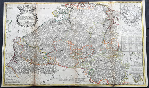
1720 Moll Large Antique Map of The Low Countries, Flanders Netherlands & Belgium
- Title : Les Provinces Des Pays-Bas Catholoiques ou. A Most excat map of Flanders or Austraian Netherlands.....Herman Moll Geogr.
- Size: 40 1/2in x 24in (1.030m x 610mm)
- Condition: (A) Very Good Condition
- Date : 1720
- Ref #: 61130
Description:
This very large beautifully hand coloured original copper-plate engraved antique map of the low country of Flanders region of The Netherlands & Belgium by Herman Moll was published in 1720 in the atlas The World Described, or a New and Correct Sett of Maps by John Bowles, Thomas Bowles, Philip Overton & John King of London.
In the 18th century many large-scale maps were published by the likes of John Senex and Herman Moll, this trend continued until the end of private mapping in the early 19th century when it was replaced by Ordnance Survey maps.
General Definitions:
Paper thickness and quality: - Heavy and stable
Paper color : - off white
Age of map color: - Original
Colors used: - Yellow, green, blue, pink
General color appearance: - Authentic
Paper size: - 40 1/2in x 24in (1.030m x 610mm)
Plate size: - 40in x 24in (1.00m x 610mm)
Margins: - Min 1/2in (12mm)
Imperfections:
Margins: - Age toning along top margin
Plate area: - Age toning along folds
Verso: - Re-enforced & age toning along folds
Background:
Flanders: In 1500, Charles V was born in Ghent. He inherited the Seventeen Provinces (1506), Spain (1516) with its colonies and in 1519 was elected Holy Roman Emperor. The Pragmatic Sanction of 1549, issued by Charles V, established the Low Countries as the Seventeen Provinces (or Spanish Netherlands in its broad sense) as an entity separate from the Holy Roman Empire and from France. In 1556 Charles V abdicated due to ill health (he suffered from crippling gout). Spain and the Seventeen Provinces went to his son, king Philip II of Spain.
Over the first half of the 16th century Antwerp grew to become the second-largest European city north of the Alps by 1560. Antwerp was the richest city in Europe at this time. According to Luc-Normand Tellier It is estimated that the port of Antwerp was earning the Spanish crown seven times more revenues than the Americas.
Meanwhile, Protestantism had reached the Low Countries. Among the wealthy traders of Antwerp, the Lutheran beliefs of the German Hanseatic traders found appeal, perhaps partly for economic reasons. The spread of Protestantism in this city was aided by the presence of an Augustinian cloister (founded 1514) in the St. Andries quarter. Luther, an Augustinian himself, had taught some of the monks, and his works were in print by 1518. The first Lutheran martyrs came from Antwerp. The Reformation resulted in consecutive but overlapping waves of reform: a Lutheran, followed by a militant Anabaptist, then a Mennonite, and finally a Calvinistic movement. These movements existed independently of each other.
Philip II, a devout Catholic and self-proclaimed protector of the Counter-Reformation, suppressed Calvinism in Flanders, Brabant and Holland (what is now approximately Belgian Limburg was part of the Bishopric of Liège and was Catholic de facto). In 1566, the wave of iconoclasm known as the Beeldenstorm was a prelude to religious war between Catholics and Protestants, especially the Anabaptists. The Beeldenstorm started in what is now French Flanders, with open-air sermons (Dutch: hagepreken) that spread through the Low Countries, first to Antwerp and Ghent, and from there further east and north. In total it lasted not even a month.
Subsequently, Philip II sent the Duke of Alba to the Provinces to repress the revolt. Alba recaptured the southern part of the Provinces, who signed the Union of Atrecht, which meant that they would accept the Spanish government on condition of more freedom. But the northern part of the provinces signed the Union of Utrecht and settled in 1581 the Republic of the Seven United Netherlands. Spanish troops quickly started fighting the rebels, but before the revolt could be completely defeated, a war between England and Spain had broken out, forcing Philips Spanish troops to halt their advance. Meanwhile, the Spanish armies had already conquered the important trading cities of Bruges and Ghent. Antwerp, which was then the most important port in the world, also had to be conquered. On 17 August 1585, Antwerp fell. This ended the Eighty Years War for the (from now on) Southern Netherlands. The United Provinces (the Northern Netherlands) fought on until 1648 – the Peace of Westphalia.
While Spain was at war with England, the rebels from the north, strengthened by refugees from the south, started a campaign to reclaim areas lost to Philip IIs Spanish troops. They managed to conquer a considerable part of Brabant (the later Noord-Brabant of the Netherlands), and the south bank of the Scheldt estuary (Zeelandic Flanders), before being stopped by Spanish troops. The front line at the end of this war stabilized and became the current border between present-day Belgium and the Netherlands. The Dutch (as they later became known) had managed to reclaim enough of Spanish-controlled Flanders to close off the river Scheldt, effectively cutting Antwerp off from its trade routes.
First the fall of Antwerp to the Spanish and later also the closing of the Scheldt were causes of a considerable emigration of Antverpians. Many of the Calvinist merchants of Antwerp and also of other Flemish cities left Flanders and emigrated to the north. A large number of them settled in Amsterdam, which was at the time a smaller port, of significance only in the Baltic trade. In the following years Amsterdam was rapidly transformed into one of the worlds most important ports. Because of the contribution of the Flemish exiles to this transformation, the exodus is sometimes described as creating a new Antwerp.
Flanders and Brabant, due to these events, went into a period of relative decline from the time of the Thirty Years War. In the Northern Netherlands however, the mass emigration from Flanders and Brabant became an important driving force behind the Dutch Golden Age.
Although arts remained at a relatively impressive level for another century with Peter Paul Rubens (1577–1640) and Anthony van Dyck, Flanders experienced a loss of its former economic and intellectual power under Spanish, Austrian, and French rule, with heavy taxation and rigid imperial political control compounding the effects of industrial stagnation and Spanish-Dutch and Franco-Austrian conflict. The Southern Netherlands suffered severely under the War of the Spanish Succession, but under the reign of Empress Maria-Theresia these lands economically flourished again. Influenced by the Enlightenment, the Austrian Emperor Joseph II was the first sovereign who had been in the Southern Netherlands since King Philip II of Spain left them in 1559.
In 1794 the French Republican Army started using Antwerp as the northernmost naval port of France, which country officially annexed Flanders the following year as the départements of Lys, Escaut, Deux-Nèthes, Meuse-Inférieure and Dyle. Obligatory (French) army service for all men aged 16–25 was one of the main reasons for the peoples uprising against the French in 1798, known as the Boerenkrijg (Peasants War), with the heaviest fighting in the Campine area.
After the defeat of Napoleon Bonaparte at the 1815 Battle of Waterloo in Waterloo, Brabant, sovereignty over the Austrian Netherlands – Belgium minus the East Cantons and Luxembourg – was given by the Congress of Vienna (1815) to the United Netherlands (Dutch: Verenigde Nederlanden), the state that briefly existed under Sovereign Prince William I of Orange Nassau, the latter King William I of the United Kingdom of the Netherlands, after the French Empire was driven out of the Dutch territories. The United Kingdom of the Netherlands was born. The Protestant King of the Netherlands, William I rapidly started the industrialisation of the southern parts of the Kingdom. The political system that was set up however, slowly but surely failed to forge a true union between the northern and the southern parts of the Kingdom. The southern bourgeoisie mainly was Roman Catholic, in contrast to the mainly Protestant north; large parts of the southern bourgeoisie also primarily spoke French rather than Dutch.
In 1815 the Dutch Senate was reinstated (Dutch: Eerste Kamer der Staaten Generaal). The nobility, mainly coming from the south, became more and more estranged from their northern colleagues. Resentment grew both between the Roman Catholics from the south and the Protestants from the north and among the powerful liberal bourgeoisie from the south and their more moderate colleagues from the north. On 25 August 1830 (after the showing of the opera La Muette de Portici of Daniel Auber in Brussels) the Belgian Revolution sparked off and became a fact. On 4 October 1830, the Provisional Government (Dutch: Voorlopig Bewind) proclaimed the independence, which was later confirmed by the National Congress that issued a new Liberal Constitution and declared the new state a Constitutional Monarchy, under the House of Saxe-Coburg. Flanders now became part of the Kingdom of Belgium, which was recognized by the major European Powers on 20 January 1831. The de facto dissidence was finally recognized by the United Kingdom of the Netherlands on 19 April 1839.
In 1830, the Belgian Revolution led to the splitting up of the two countries. Belgium was confirmed as an independent state by the Treaty of London of 1839, but deprived of the eastern half of Limburg (now Dutch Limburg), and the Eastern half of Luxembourg (now the Grand-Duchy of Luxembourg). Sovereignty over Zeelandic Flanders, south of the Westerscheldt river delta, was left with the Kingdom of the Netherlands, which was allowed to levy a toll on all traffic to Antwerp harbour until 1863.
The Belgian Revolution was not well supported in Flanders and even on 4 October 1830, when the Belgian independence was eventually declared, Flemish authorities refused to take orders from the new Belgian government in Brussels. Only after Flanders was subdued with the aid of a large French military force one month later, under the leadership of the Count de Pontécoulant, did Flanders become a true part of Belgium.
The French-speaking bourgeoisie showed very little respect for the Dutch-speaking part of the population. French became the only official language in Belgium and all secondary and higher education in the Dutch language was abolished.
In 1834, all people even remotely suspected of being Flemish minded or calling for the reunification of the Netherlands were prosecuted and their houses looted and burnt. Flanders, until then a very prosperous European region, was not considered worthwhile for investment and scholarship. A study in 1918 demonstrated that in the first 88 years of its existence, 80% of the Belgian GNP was invested in Wallonia. This led to a widespread poverty in Flanders, forcing roughly 300.000 Flemish to emigrate to Wallonia to start working there in the heavy industry.John SenexMoll
All of these events led to a silent uprising in Flanders against the French-speaking domination. But it was not until 1878 that Dutch was allowed to be used for official purposes in Flanders (see language legislation in Belgium), although French remained the only official language in Belgium.
In 1873, Dutch became the official language in public secondary schools. In 1898 Dutch and French were declared equal languages in laws and Royal orders. In 1930 the first Flemish university was opened. The first official translation of the Belgian constitution in Dutch was not published until 1967.
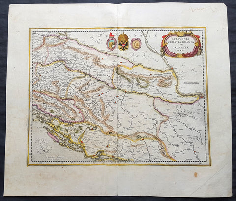
1639 Jansson & Mercator Original Antique Map Slovenia, Croatia, Bosnia, Dalmatia
- Title : Sclavonia, Croatia, Bosnia cum Dalmatiae Parte
- Date : 1639
- Size: 23in x 19 1/2in (585mm x 495mm)
- Ref #: 70702
- Condition: (A) Very Good Condition
Description:
This beautifully hand coloured original antique map of part of the former Yugoslavia, Slovenia, Croatia, Bosnia, Dalmatia and neighboring regions was published in the 1639 French Edition of Mercator's Atlas published by Mercators successors Jan Jansson & Henricus Hondius.
General Definitions:
Paper thickness and quality: - Heavy and stable
Paper color : - off white
Age of map color: - Original
Colors used: - Yellow, green, blue, pink
General color appearance: - Authentic
Paper size: - 23in x 19 1/2in (585mm x 495mm)
Plate size: - 18 1/2in x 14 1/4in (470mm x 365mm)
Margins: - Min 2in (50mm)
Imperfections:
Margins: - Age toning
Plate area: - Light creasing along centerfold
Verso: - Top margin centerfold re-joined
Background:
The map covers the western part of the Balkans from Varazdin, Croatia south to Brac and from the Adriatic Sea and Arbe east as far as Belgrade and includes parts of the modern day countries of Croatia, Slovenia, Serbia and Bosnia and Herzegovina. Renders the region in extraordinary detail, noting rivers, towns, islands and a host of other topographical features with forests and mountains beautifully rendered in profile. The map includes the coats of arms of the Ottomans, Serbia & Slavonia near the top border and a beautifully illustrated title cartouche adorns the top right of the map.
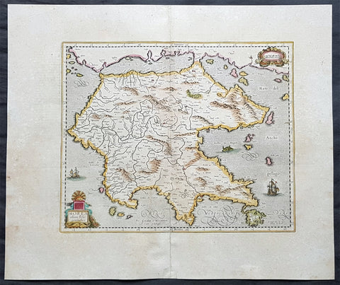
1639 Hondius & Mercator Antique Map of Morea The Greek Peloponnese
- Title : Morea olim Peloponnesus
- Date : 1639
- Size: 23in x 19in (585mm x 480mm)
- Ref #: 43164
- Condition: (A+) Fine Condition
Description:
This fine, beautifully hand coloured original antique map of the Greek Peloponnese was published in the 1639 French edition of Gerardi Mercators Atlantis Novi Atlas by Jan Jansson and Henricus Hondius.
Background: The Peloponnese Peninsula had played a central role in both history and culture since Homeric times. The large peninsula is connected to mainland Greece only by the narrow Isthmus of Corinth, and jutting deeply southwards, it lay along the crossroads of shipping in the Mediterranean and Aegean seas. Many places still familiar today are labelled on the map, including 'Coryato' (Corinth), 'Napoli' (Nafplio), Patras and 'Cithera' (Cythera), while Athens appears in Attica, to the northeast.
Prominenty featured in the upper part of the map is the Gulf of Lepanto in 1571, the site of an epic naval battle between the forces of the Ottoman Empire and the combined forces of various European states. The outcome was a historical turning point, as it ensured Western maritime supremacy over the Ottomans for decades to come. Even in 1619, almost half a century later, when the present map was printed, the Battle of Lepanto was still top of mind. (Ref: Koeman; M&B)
Condition Report:
Paper thickness and quality: - Heavy & stable
Paper color: - off white
Age of map color: - Original
Colors used: - Yellow, pink, green
General color appearance: - Authentic
Paper size: - 23in x 19in (585mm x 480mm)
Plate size: - 16 1/2in x 13 1/2in (420mm x 345mm)
Margins: - Min 1in (25mm)
Imperfections:
Margins: - Light age toning
Plate area: - None
Verso: - Bottom centerfold re-joined, no loss
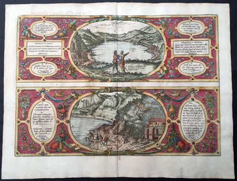
1572 Braun & Hogenberg Antique Print View Lake Agnano Cave of Dogs Naples, Italy
- Title : Antri Sibillae, Lacus Agnianus
- Ref #: 35013
- Size: 20 3/4in x 16in (525mm x 405mm)
- Date : 1572
- Condition: (A+) Fine Condition
Description:
This beautifully hand coloured original antique print, a birds eye view of the Italian Volcanic Lake Agnano and the Grotta del cane or Fontana - Cave of the Dogs - located in Pozzuoli, north of Naples, Italy was published by Georg Braun & Frans Hogenberg for the 1572 atlas of town plans Civiates Orbis Terrarum intended as a companion to Abraham Ortelius's master Atlas Theatrum Orbis Terrarum published in 1570.
The top view of Lake Agnano shows friends Abraham Ortelius & Georg Hoffnagel meeting at the Lake in a way to impress upon the reader the real importance of Nature. These are beautifully engraved with wonderful hand colouring on strong, sturdy paper.
General Description:
Paper thickness and quality: - Heavy and stable
Paper color: - off white
Age of map color: - Early
Colors used: - Green, blue, red, yellow
General color appearance: - Authentic
Paper size: - 20 3/4in x 16in (525mm x 405mm)
Plate size: - 18 1/2in x 13in (470mm x 330mm)
Margins: - Min 1in (25mm)
Imperfections:
Margins: - None
Plate area: - None
Verso: - Colour show-through
The Cave of Dogs is a small cave on the eastern side of the Phlegraean Fields near Pozzuoli, Naples. Inside the cave is a fumarole that releases carbon dioxide of volcanic origin. It was a famous if gruesome tourist attraction for travellers on the Grand Tour. The CO2 gas, being denser than air, tends to accumulate in the deeper parts of the cave. Local guides, for a fee, would suspend small animals inside it—usually dogs—until they became unconscious. Because humans inhaled air from a higher level they were not affected. The dogs might be revived by submerging them in the cold waters of the nearby Lake Agnano. Famous tourists who came to see this attraction included Goethe, Alexandre Dumas père, and Mark Twain. The lake became polluted and it was drained in 1870; the spectacle fell into desuetude and the cave was closed. However the area is now being restored by volunteers.
Lago di Agnano or Lake Agnano was a circular lake, some 6½ km in circumference, which occupied the crater of the extinct volcano of Agnano 8 km west of Naples, Italy. It was apparently not formed until the Middle Ages, as it is not mentioned by ancient writers; it was drained in 1870.
On the south bank are the Stufe di San Germano, natural sulphureous vapour baths, and close by is the Grotta del Cane. From the floor of this cave warm carbonic acid gas constantly rises to a height of 18 inches (46 cm): the fumes render a dog insensible in a few seconds. It is mentioned by Pliny the Elder. Remains of an extensive Roman building and some statues have been discovered close by.(Ref: Tooley; M&B)

1719 Henri Chatelain Large Antique Map, a Plan of Rome, Italy
- Title : Rome Ancienne et Moderne
- Ref #: 82075
- Size: 20 1/2in x 17in (520mm x 430mm)
- Date : 1719
- Condition: (A+) Fine Condition
Description:
This beautifully hand coloured original antique map of Rome, comparing ancient Rome against contemporary Rome in the early 18th century was published in the 1719 edition of Henri Abraham Chatelains Atlas Historique.
General Definitions:
Paper thickness and quality: - Heavy and stable
Paper color : - off white
Age of map color: - Early
Colors used: - Yellow, green, blue, pink
General color appearance: - Authentic
Paper size: - 20 1/2in x 17in (520mm x 430mm)
Plate size: - 17 1/2in x 13 1/2in (445mm x 340mm)
Margins: - Min 1in (25mm)
Imperfections:
Margins: - None
Plate area: - None
Verso: - None
Background:
The history of Rome spans 28 centuries. While Roman mythology dates the founding of Rome at around 753 BC, the site has been inhabited for much longer, making it one of the oldest continuously occupied sites in Europe. The cities early population originated from a mix of Latins, Etruscans, and Sabines. Eventually, the city successively became the capital of the Roman Kingdom, the Roman Republic and the Roman Empire, and is regarded as the birthplace of Western civilization and by some as the first ever metropolis. It was first called The Eternal City by the Roman poet Tibullus in the 1st century BC, and the expression was also taken up by Ovid, Virgil, and Livy. Rome is also called the Caput Mundi (Capital of the World). After the fall of the Western Empire, which marked the beginning of the Middle Ages, Rome slowly fell under the political control of the Papacy, which had settled in the city since the 1st century AD, until in the 8th century it became the capital of the Papal States, which lasted until 1870. Beginning with the Renaissance, almost all the popes since Nicholas V (1447–1455) pursued over four hundred years a coherent architectural and urban program aimed at making the city the artistic and cultural centre of the world. In this way, Rome became first one of the major centres of the Italian Renaissance, and then the birthplace of both the Baroque style and Neoclassicism. Famous artists, painters, sculptors and architects made Rome the centre of their activity, creating masterpieces throughout the city. In 1871, Rome became the capital of the Kingdom of Italy, which, in 1946, became the Italian Republic. (Ref: Tooley; M&B)
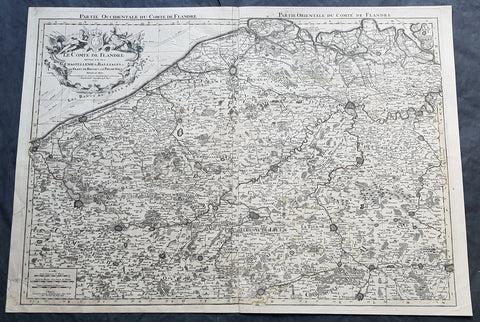
1692 Alexis Jaillot Large Antique Map Flanders Region of Netherlands & Belgium
- Title : Le Comte De Flandre Divisee en ses Chastellenie, Balliages &c.....1692
- Size: 34in x 24in (865mm x 610mm)
- Condition: (B) Good Condition
- Date : 1692
- Ref #: 16384
Description:
This very large, hand coloured original antique map of Flanders region of The Netherlands and Belgium, by Alexis Hubert Jaillot - after Nicolas Sanson - was engraved in 1692 - the date is engraved in the title cartouche.
This large highly detailed map centers on the Brugge to the north, south to Douay west to Dunkirk and east to Dendermonde.
General Definitions:
Paper thickness and quality: - Heavy and stable
Paper color : - off white
Age of map color: - Original
Colors used: - Yellow, green, blue, pink
General color appearance: - Authentic
Paper size: - 34in x 24in (865mm x 610mm)
Plate size: - 33in x 23in (855mm x 600mm)
Margins: - Min 1/2in (12mm)
Imperfections:
Margins: - Soiling and creasing in margins
Plate area: - Light uplift along centerfold, light soiling
Verso: - Soiling and creasing
Background:
Flanders: In 1500, Charles V was born in Ghent. He inherited the Seventeen Provinces (1506), Spain (1516) with its colonies and in 1519 was elected Holy Roman Emperor. The Pragmatic Sanction of 1549, issued by Charles V, established the Low Countries as the Seventeen Provinces (or Spanish Netherlands in its broad sense) as an entity separate from the Holy Roman Empire and from France. In 1556 Charles V abdicated due to ill health (he suffered from crippling gout). Spain and the Seventeen Provinces went to his son, king Philip II of Spain.
Over the first half of the 16th century Antwerp grew to become the second-largest European city north of the Alps by 1560. Antwerp was the richest city in Europe at this time. According to Luc-Normand Tellier It is estimated that the port of Antwerp was earning the Spanish crown seven times more revenues than the Americas.
Meanwhile, Protestantism had reached the Low Countries. Among the wealthy traders of Antwerp, the Lutheran beliefs of the German Hanseatic traders found appeal, perhaps partly for economic reasons. The spread of Protestantism in this city was aided by the presence of an Augustinian cloister (founded 1514) in the St. Andries quarter. Luther, an Augustinian himself, had taught some of the monks, and his works were in print by 1518. The first Lutheran martyrs came from Antwerp. The Reformation resulted in consecutive but overlapping waves of reform: a Lutheran, followed by a militant Anabaptist, then a Mennonite, and finally a Calvinistic movement. These movements existed independently of each other.
Philip II, a devout Catholic and self-proclaimed protector of the Counter-Reformation, suppressed Calvinism in Flanders, Brabant and Holland (what is now approximately Belgian Limburg was part of the Bishopric of Liège and was Catholic de facto). In 1566, the wave of iconoclasm known as the Beeldenstorm was a prelude to religious war between Catholics and Protestants, especially the Anabaptists. The Beeldenstorm started in what is now French Flanders, with open-air sermons (Dutch: hagepreken) that spread through the Low Countries, first to Antwerp and Ghent, and from there further east and north. In total it lasted not even a month.
Subsequently, Philip II sent the Duke of Alba to the Provinces to repress the revolt. Alba recaptured the southern part of the Provinces, who signed the Union of Atrecht, which meant that they would accept the Spanish government on condition of more freedom. But the northern part of the provinces signed the Union of Utrecht and settled in 1581 the Republic of the Seven United Netherlands. Spanish troops quickly started fighting the rebels, but before the revolt could be completely defeated, a war between England and Spain had broken out, forcing Philips Spanish troops to halt their advance. Meanwhile, the Spanish armies had already conquered the important trading cities of Bruges and Ghent. Antwerp, which was then the most important port in the world, also had to be conquered. On 17 August 1585, Antwerp fell. This ended the Eighty Years War for the (from now on) Southern Netherlands. The United Provinces (the Northern Netherlands) fought on until 1648 – the Peace of Westphalia.
While Spain was at war with England, the rebels from the north, strengthened by refugees from the south, started a campaign to reclaim areas lost to Philip IIs Spanish troops. They managed to conquer a considerable part of Brabant (the later Noord-Brabant of the Netherlands), and the south bank of the Scheldt estuary (Zeelandic Flanders), before being stopped by Spanish troops. The front line at the end of this war stabilized and became the current border between present-day Belgium and the Netherlands. The Dutch (as they later became known) had managed to reclaim enough of Spanish-controlled Flanders to close off the river Scheldt, effectively cutting Antwerp off from its trade routes.
First the fall of Antwerp to the Spanish and later also the closing of the Scheldt were causes of a considerable emigration of Antverpians. Many of the Calvinist merchants of Antwerp and also of other Flemish cities left Flanders and emigrated to the north. A large number of them settled in Amsterdam, which was at the time a smaller port, of significance only in the Baltic trade. In the following years Amsterdam was rapidly transformed into one of the worlds most important ports. Because of the contribution of the Flemish exiles to this transformation, the exodus is sometimes described as creating a new Antwerp.
Flanders and Brabant, due to these events, went into a period of relative decline from the time of the Thirty Years War. In the Northern Netherlands however, the mass emigration from Flanders and Brabant became an important driving force behind the Dutch Golden Age.
Although arts remained at a relatively impressive level for another century with Peter Paul Rubens (1577–1640) and Anthony van Dyck, Flanders experienced a loss of its former economic and intellectual power under Spanish, Austrian, and French rule, with heavy taxation and rigid imperial political control compounding the effects of industrial stagnation and Spanish-Dutch and Franco-Austrian conflict. The Southern Netherlands suffered severely under the War of the Spanish Succession, but under the reign of Empress Maria-Theresia these lands economically flourished again. Influenced by the Enlightenment, the Austrian Emperor Joseph II was the first sovereign who had been in the Southern Netherlands since King Philip II of Spain left them in 1559.
In 1794 the French Republican Army started using Antwerp as the northernmost naval port of France, which country officially annexed Flanders the following year as the départements of Lys, Escaut, Deux-Nèthes, Meuse-Inférieure and Dyle. Obligatory (French) army service for all men aged 16–25 was one of the main reasons for the peoples uprising against the French in 1798, known as the Boerenkrijg (Peasants War), with the heaviest fighting in the Campine area.
After the defeat of Napoleon Bonaparte at the 1815 Battle of Waterloo in Waterloo, Brabant, sovereignty over the Austrian Netherlands – Belgium minus the East Cantons and Luxembourg – was given by the Congress of Vienna (1815) to the United Netherlands (Dutch: Verenigde Nederlanden), the state that briefly existed under Sovereign Prince William I of Orange Nassau, the latter King William I of the United Kingdom of the Netherlands, after the French Empire was driven out of the Dutch territories. The United Kingdom of the Netherlands was born. The Protestant King of the Netherlands, William I rapidly started the industrialisation of the southern parts of the Kingdom. The political system that was set up however, slowly but surely failed to forge a true union between the northern and the southern parts of the Kingdom. The southern bourgeoisie mainly was Roman Catholic, in contrast to the mainly Protestant north; large parts of the southern bourgeoisie also primarily spoke French rather than Dutch.
In 1815 the Dutch Senate was reinstated (Dutch: Eerste Kamer der Staaten Generaal). The nobility, mainly coming from the south, became more and more estranged from their northern colleagues. Resentment grew both between the Roman Catholics from the south and the Protestants from the north and among the powerful liberal bourgeoisie from the south and their more moderate colleagues from the north. On 25 August 1830 (after the showing of the opera La Muette de Portici of Daniel Auber in Brussels) the Belgian Revolution sparked off and became a fact. On 4 October 1830, the Provisional Government (Dutch: Voorlopig Bewind) proclaimed the independence, which was later confirmed by the National Congress that issued a new Liberal Constitution and declared the new state a Constitutional Monarchy, under the House of Saxe-Coburg. Flanders now became part of the Kingdom of Belgium, which was recognized by the major European Powers on 20 January 1831. The de facto dissidence was finally recognized by the United Kingdom of the Netherlands on 19 April 1839.
In 1830, the Belgian Revolution led to the splitting up of the two countries. Belgium was confirmed as an independent state by the Treaty of London of 1839, but deprived of the eastern half of Limburg (now Dutch Limburg), and the Eastern half of Luxembourg (now the Grand-Duchy of Luxembourg). Sovereignty over Zeelandic Flanders, south of the Westerscheldt river delta, was left with the Kingdom of the Netherlands, which was allowed to levy a toll on all traffic to Antwerp harbour until 1863.
The Belgian Revolution was not well supported in Flanders and even on 4 October 1830, when the Belgian independence was eventually declared, Flemish authorities refused to take orders from the new Belgian government in Brussels. Only after Flanders was subdued with the aid of a large French military force one month later, under the leadership of the Count de Pontécoulant, did Flanders become a true part of Belgium.
The French-speaking bourgeoisie showed very little respect for the Dutch-speaking part of the population. French became the only official language in Belgium and all secondary and higher education in the Dutch language was abolished.
In 1834, all people even remotely suspected of being Flemish minded or calling for the reunification of the Netherlands were prosecuted and their houses looted and burnt. Flanders, until then a very prosperous European region, was not considered worthwhile for investment and scholarship. A study in 1918 demonstrated that in the first 88 years of its existence, 80% of the Belgian GNP was invested in Wallonia. This led to a widespread poverty in Flanders, forcing roughly 300.000 Flemish to emigrate to Wallonia to start working there in the heavy industry.
All of these events led to a silent uprising in Flanders against the French-speaking domination. But it was not until 1878 that Dutch was allowed to be used for official purposes in Flanders (see language legislation in Belgium), although French remained the only official language in Belgium.
In 1873, Dutch became the official language in public secondary schools. In 1898 Dutch and French were declared equal languages in laws and Royal orders. In 1930 the first Flemish university was opened. The first official translation of the Belgian constitution in Dutch was not published until 1967.

1572 Braun & Hogenberg Antique Print View Lake Agnano Cave of Dogs Naples, Italy
- Title : Antri Sibillae, Lacus Agnianus
- Ref #: 35013
- Size: 20 3/4in x 16in (525mm x 405mm)
- Date : 1572
- Condition: (A+) Fine Condition
Description:
This beautifully hand coloured original antique print, a birds eye view of the Italian Volcanic Lake Agnano and the Grotta del cane or Fontana - Cave of the Dogs - located in Pozzuoli, north of Naples, Italy was published by Georg Braun & Frans Hogenberg for the 1572 atlas of town plans Civiates Orbis Terrarum intended as a companion to Abraham Ortelius's master Atlas Theatrum Orbis Terrarum published in 1570.
The top view of Lake Agnano shows friends Abraham Ortelius & Georg Hoffnagel meeting at the Lake in a way to impress upon the reader the real importance of Nature. These are beautifully engraved with wonderful hand colouring on strong, sturdy paper.
General Description:
Paper thickness and quality: - Heavy and stable
Paper color: - off white
Age of map color: - Early
Colors used: - Green, blue, red, yellow
General color appearance: - Authentic
Paper size: - 20 3/4in x 16in (525mm x 405mm)
Plate size: - 18 1/2in x 13in (470mm x 330mm)
Margins: - Min 1in (25mm)
Imperfections:
Margins: - None
Plate area: - None
Verso: - Colour show-through
The Cave of Dogs is a small cave on the eastern side of the Phlegraean Fields near Pozzuoli, Naples. Inside the cave is a fumarole that releases carbon dioxide of volcanic origin. It was a famous if gruesome tourist attraction for travellers on the Grand Tour. The CO2 gas, being denser than air, tends to accumulate in the deeper parts of the cave. Local guides, for a fee, would suspend small animals inside it—usually dogs—until they became unconscious. Because humans inhaled air from a higher level they were not affected. The dogs might be revived by submerging them in the cold waters of the nearby Lake Agnano. Famous tourists who came to see this attraction included Goethe, Alexandre Dumas père, and Mark Twain. The lake became polluted and it was drained in 1870; the spectacle fell into desuetude and the cave was closed. However the area is now being restored by volunteers.
Lago di Agnano or Lake Agnano was a circular lake, some 6½ km in circumference, which occupied the crater of the extinct volcano of Agnano 8 km west of Naples, Italy. It was apparently not formed until the Middle Ages, as it is not mentioned by ancient writers; it was drained in 1870.
On the south bank are the Stufe di San Germano, natural sulphureous vapour baths, and close by is the Grotta del Cane. From the floor of this cave warm carbonic acid gas constantly rises to a height of 18 inches (46 cm): the fumes render a dog insensible in a few seconds. It is mentioned by Pliny the Elder. Remains of an extensive Roman building and some statues have been discovered close by.(Ref: Tooley; M&B)
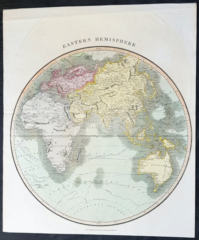
1815 John Thomson Large Antique Map Eastern Hemisphere, New Holland, Cpt. Cook
- Title : Eastern Hemisphere....Drawn & engraved for Thomsons New General Atlas, 1815
- Date : 1815
- Size: 23in x 20in (380mm x 505mm)
- Condition: (A+) Fine Condition
- Ref: 30863
Description:
This large magnificent original hand coloured copper-plate engraved antique map of The Eastern Hemisphere - Europe, Africa, Asia, New Holland (Australia) was drawn & engraved by John Thomson in 1815 - dated at the foot of the map - and was published in the 1817 edition of Thomsons New General Atlas
Beautiful large map containing the tracks of the 3 voyages of Capt Cook, and also including the tracks of the explorers George Vancouver, Gore
General Definitions:
Paper thickness and quality: - Heavy and stable
Paper color : - off white
Age of map color: - Original
Colors used: - Yellow, green, blue, pink
General color appearance: - Authentic
Paper size: - 23in x 20in (380mm x 505mm)
Plate size: - 23in x 20in (380mm x 505mm)
Margins: - Min 1/2in (15mm)
Imperfections:
Margins: - None
Plate area: - None
Verso: - None
Background:
The first recorded European sighting of the Australian mainland, and the first recorded European landfall on the Australian continent (in 1606), are attributed to the Dutch. The first ship and crew to chart the Australian coast and meet with Aboriginal people was the Duyfken captained by Dutch navigator, Willem Janszoon. He sighted the coast of Cape York Peninsula in early 1606, and made landfall on 26 February at the Pennefather River near the modern town of Weipa on Cape York. The Dutch charted the whole of the western and northern coastlines and named the island continent New Holland during the 17th century, but made no attempt at settlement. William Dampier, an English explorer and privateer, landed on the north-west coast of New Holland in 1688 and again in 1699 on a return trip. In 1770, James Cook sailed along and mapped the east coast, which he named New South Wales and claimed for Great Britain.
With the loss of its American colonies in 1783, the British Government sent a fleet of ships, the First Fleet, under the command of Captain Arthur Phillip, to establish a new penal colony in New South Wales. A camp was set up and the flag raised at Sydney Cove, Port Jackson, on 26 January 1788, a date which became Australias national day, Australia Day. A British settlement was established in Van Diemens Land, now known as Tasmania, in 1803, and it became a separate colony in 1825. The United Kingdom formally claimed the western part of Western Australia (the Swan River Colony) in 1828. Separate colonies were carved from parts of New South Wales: South Australia in 1836, Victoria in 1851, and Queensland in 1859. The Northern Territory was founded in 1911 when it was excised from South Australia. South Australia was founded as a free province—it was never a penal colony. Victoria and Western Australia were also founded free, but later accepted transported convicts. A campaign by the settlers of New South Wales led to the end of convict transportation to that colony; the last convict ship arrived in 1848.
The indigenous population, estimated to have been between 750,000 and 1,000,000 in 1788, declined for 150 years following settlement, mainly due to infectious disease. Thousands more died as a result of frontier conflict with settlers. A government policy of assimilation beginning with the Aboriginal Protection Act 1869 resulted in the removal of many Aboriginal children from their families and communities—often referred to as the Stolen Generations—a practice which may also have contributed to the decline in the indigenous population. As a result of the 1967 referendum, the Federal governments power to enact special laws with respect to a particular race was extended to enable the making of laws with respect to Aborigines.[68] Traditional ownership of land (native title) was not recognised in law until 1992, when the High Court of Australia held in Mabo v Queensland (No 2) that the legal doctrine that Australia had been terra nullius (land belonging to no one) did not apply to Australia at the time of British settlement.
A gold rush began in Australia in the early 1850s and the Eureka Rebellion against mining licence fees in 1854 was an early expression of civil disobedience. Between 1855 and 1890, the six colonies individually gained responsible government, managing most of their own affairs while remaining part of the British Empire. The Colonial Office in London retained control of some matters, notably foreign affairs, defence and international shipping.
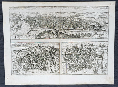
1574 Braun & Hogenberg Antique Map City Views of Rouen, Nimes & Bordeaux France
- Title : Rotomagus Vulgo Roan Normandie Metropolis / Nemausus, Nismes, Civitas Narbonensis . . . / Civitatis Burdengalensis in Aquitanea, Genuina Descrip (Rouen, Nimes & Bordeaux)
- Size: 21in x 16in (545mm x 410mm)
- Condition: (A+) Fine Condition
- Date : 1574
- Ref #: 40168
Description:
This original copper-plate engraved antique of 3 x maps, birds eye city views of Rouen, Nime, and Bordeaux, France was published by Georg Braun & Frans Hogenberg for the 1574 atlas of town plans Civiates Orbis Terrarum intended as a companion to Abraham Ortelius\\\'s master Atlas Theatrum Orbis Terrarum published in 1570.
General Definitions:
Paper thickness and quality: - Heavy and stable
Paper color : - off white
Age of map color: -
Colors used: -
General color appearance: -
Paper size: - 21in x 16in (545mm x 410mm)
Plate size: - 19in x 13 1/2in (480mm x 340mm)
Margins: - Min 1in (25mm)
Imperfections:
Margins: - None
Plate area: - None
Verso: - None
Background:
Rouen: The cities favourable position between the Seine to the south and the hills in the north is clearly illustrated in this view; which is seen from the east from an ideal hill and which also shows the intact city walls from the Roman era. The staffage emphasizes the course taken by the road from Paris leading into the city.
Nimes was a flourishing settlement even in Celtic times and due to its favourable location on the Via Domitia, a major transportation route linking Italy and Spain, was developed into the capital of Narbonensis province. Amongst other things, it was given a 7-km-long city wall and the dominant Tour Magne watchtower (top centre). Also stemming from Roman times is the imposing amphitheatre which could seat some 23,000 spectators and is used for performances even today. Its facade, comprising two storeys, each with 60 arches, is clearly recognizable, even in foreshortening. Above the cathedral and clock tower lies the Maison Carrée, a Roman temple built by Marcus Vipsanius Agrippa around 19 B.C. The 49-m-high Pont du Gard aqueduct, mentioned by Braun and visible top right, is an important work of Roman civil engineering.
Bordeaux: The fortifications were built by Charles VII of France only following the reconquest of Bordeaux in 1452. Shown on a smaller scale to the right of the château is the Gothic cathedral of Saint-André with its free-standing clock tower, the Tour Pey-Berland. Outside the city walls lie the ruins of the Roman amphitheatre.
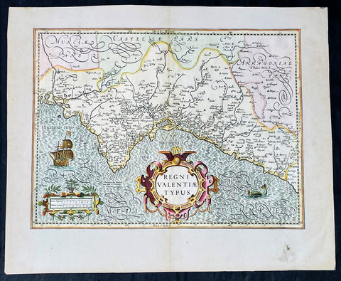
1628 Henricus Hondius Antique Map Valencia Region of Spain & Mediterranean Sea
Antique Map
- Title : Regni Valentiae Typus
- Date : 1628
- Size: 22 1/2in x 18 1/2in (570mm x 470mm)
- Condition: (A+) Fine Condition
- Ref: 35640
Description:
This beautifully engraved hand coloured original antique map of Valencia Region of Spain was published in the 1628 French edition of Mercator's atlas by Jan Jansson and Henricus Hondius.
These maps, published in the later editions of Mercators atlas, are derived from the original maps drawn and engraved by Gerald Mercator in the mid to late 16th century, published by his son Rumold as an atlas, after his death, in 1595. After two editions the plates were purchased by Jodocus Hondius in 1604 and continued to be published until the mid 1630's when the plates were re-engraved and updated by Jan Jansson and Henricus Hondius.
General Definitions:
Paper thickness and quality: - Heavy and stable
Paper color : - off white
Age of map color: - Original & later
Colors used: - Yellow, green, pink
General color appearance: - Authentic
Paper size: - 22 3/4in x 19 3/4in (580mm x 500mm)
Plate size: - 20in x 13 3/4in (500mm x 350mm)
Margins: - Min 1in (25mm)
Imperfections:
Margins: - Light soiling
Plate area: - None
Verso: - None
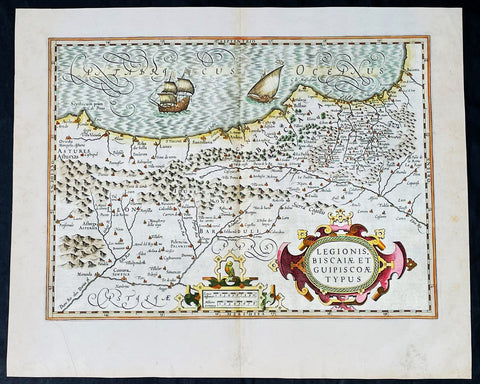
1628 Henricus Hondius Antique Map of the Basque Region of Spain
Antique Map
- Title : Legionis, Biscaiae Et Guipiscoae Typus
- Date : 1628
- Size: 22 1/2in x 18 1/2in (570mm x 470mm)
- Condition: (A+) Fine Condition
- Ref: 35641
Description:
This beautifully engraved hand coloured original antique map of Basque Region of Spain was published in the 1628 French edition of Mercator's atlas by Jan Jansson and Henricus Hondius.
These maps, published in the later editions of Mercators atlas, are derived from the original maps drawn and engraved by Gerald Mercator in the mid to late 16th century, published by his son Rumold as an atlas, after his death, in 1595. After two editions the plates were purchased by Jodocus Hondius in 1604 and continued to be published until the mid 1630's when the plates were re-engraved and updated by Jan Jansson and Henricus Hondius.
General Definitions:
Paper thickness and quality: - Heavy and stable
Paper color : - off white
Age of map color: - Original & later
Colors used: - Yellow, green, pink
General color appearance: - Authentic
Paper size: - 22 3/4in x 19 3/4in (580mm x 500mm)
Plate size: - 20in x 13 3/4in (500mm x 350mm)
Margins: - Min 1in (25mm)
Imperfections:
Margins: - None
Plate area: - None
Verso: - None
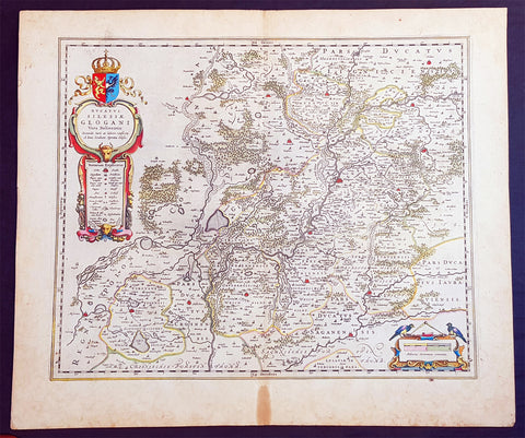
1634 Joan Blaeu Large Antique Map of Glogow, Lower Silesia, Poland
- Title : Ducatus Silesiae Glogani Vera Delineatio.
- Ref #: 93486
- Size: 23 1/2in x 20 1/2in (600mm x 520mm)
- Date : 1634
- Condition: (A+) Fine Condition
Description:
This beautifully hand coloured original copper-plate engraved antique, rare map of the Duchy of Glogow, in the ancient region of Silesia, Poland - centering on the city of Glogow - was published by Joan Blaeu in the 1634 French edition of Atlas Nouvs,.
General Definitions:
Paper thickness and quality: - Heavy and stable
Paper color : - off white
Age of map color: - Original
Colors used: - Yellow, green, blue, pink
General color appearance: - Authentic
Paper size: - 23 1/2in x 20 1/2in (600mm x 520mm)
Plate size: - 20in x 16 1/2in (510mm x 420mm)
Margins: - Min 1in (25mm)
Imperfections:
Margins: - Light age toning in margins
Plate area: - None
Verso: - None
Background:
The Duchy of Głogów was one of the Duchies of Silesia ruled by the Silesian Piasts. Its capital was Głogów in Lower Silesia.
In 1177, under the rule of Konrad Spindleshanks, the youngest son of High Duke Władysław II the Exile of Poland, the town of Głogów had already become the capital of a duchy in its own right. However, when Konrad died between 1180 and 1190, his duchy was again inherited by his elder brother Bolesław I the Tall, Duke of Wrocław. After the death of Bolesławs grandson Duke Henry II the Pious at the 1241 Battle of Legnica his sons in 1248 divided the Lower Silesian Duchy of Wrocław among themselves. Konrad I, a child when his father died, claimed his rights too and in 1251 and received the northern Głogów territory from his elder brother Bolesław II the Bald, then Duke of Legnica.
Under the rule of Konrads son Henry III the principality became smaller, as fragmentation and division continued, and other, smaller duchies were split from it like Ścinawa (Steinau, Stínava) and Żagań (Sagan, Zaháň) in 1273 as well as the duchies of Oleśnica (Oels, Olešnice) and Wołów (Wohlau, Volov) in 1312. After Henrys son Przemko II had died without heirs in 1331, King John the Blind was able to seize the duchy as a fiefdom of the Kingdom of Bohemia and granted it to the Piast Duke Henry I of Jawor six years later. As Henry I left no issue, King Johns son, Charles IV incorporated one half of Głogów into Crown of Bohemia, granting the remaining half to Duke Henry V of Iron of Żagań in 1349.
When in 1476 the Głogów line of the Piast dynasty became extinct with the death of Henry XI, fights over his succession broke out between his cousin Duke Jan II the Mad of Żagań and Elector Albert III Achilles of Brandenburg, the father of Henrys widow Barbara of Brandenburg. In consequence the duchys northern part of Krosno Odrzańskie (Crossen an der Oder) was incorporated by the Margraviate of Brandenburg in 1482. The truce however was broken by Duke Jan II, who continued his attacks on the neighbouring territories and in 1480 even invaded the royal Bohemian half of the Głogów duchy. This action finally brought the Bohemian antiking Matthias Corvinus to the scene, who in 1488 conquered Głogów, deposed Jan II and made his son János the duke.
Upon Matthias death in 1490 his territories were reacquired by Bohemian king Vladislaus II Jagiellon, who granted the fief of Głogów to his brothers John I Albert in 1491 and later Sigismund I the Old in 1499, both future kings of Poland. In 1506 the duchy finally became an immediate dominion of the Bohemian Crown, which, after Vladislaus son Louis II Jagiellon had died in 1526, were inherited by Archduke Ferdinand I of Austria and became part of the Habsburg Monarchy.
Głogów remained part of the Crown of Bohemia within the province of Silesia until the end of the First Silesian War in 1742 when, like the majority of Silesia, it became part of Frederick the Greats Kingdom of Prussia (which was definitively confirmed by the Treaty of Aachen in 1748). Even the Seven Years War did not change this status. In 1815 the Duchy (along with other Silesian duchies) ceased to exist due to radical administrative reform. All of Silesia was unified into a single administrative unit, Province of Silesia (Provinz Schlesien).
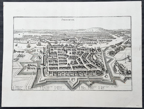
1652 Merian Antique Map Birds Eye View of the City of Szczecin or Stettin Poland
- Title : Stetinum
- Ref #: 93492
- Size: 15 1/2in x 11 1/2in (385mm x 295mm)
- Date : 1652
- Condition: (A+) Fine Condition
Description:
This original copper-plate engraved antique map a birds-eye view of the city of Szczecin or Stettin, then located in Germany, now Poland, by Matthaus Merian was published in the 1652 edition of Theatrum Europaeum
General Definitions:
Paper thickness and quality: - Heavy and stable
Paper color : - off white
Age of map color: -
Colors used: -
General color appearance: -
Paper size: - 15 1/2in x 11 1/2in (385mm x 295mm)
Plate size: - 13 1/2in x 8 1/2in (335mm x 210mm)
Margins: - Min 1in (25mm)
Imperfections:
Margins: - None
Plate area: - None
Verso: - None
Background:
Szczecin/Stettin is the capital and largest city of the West Pomeranian Voivodeship in northwestern Poland. Located near the Baltic Sea and the German border, it is a major seaport and Polands seventh-largest city.
Szczecin is located on the river Oder, south of the Szczecin Lagoon and the Bay of Pomerania. The city is situated along the southwestern shore of Dąbie Lake, on both sides of the Oder and on several large islands between the western and eastern branches of the river. Szczecin is adjacent to the town of Police and is the urban centre of the Szczecin agglomeration, an extended metropolitan area that includes communities in the German states of Brandenburg and Mecklenburg-Vorpommern.
The cities recorded history began in the 8th century as a Lechitic Pomeranian stronghold, built at the site of the Ducal castle. In the 12th century, when Szczecin had become one of Pomeranias main urban centres, it lost its independence to Piast Poland, the Duchy of Saxony, the Holy Roman Empire and Denmark. At the same time, the House of Griffins established themselves as local rulers and the population was Christianized. After the Treaty of Stettin in 1630, the town came under the control of the Swedish Empire and became in 1648 the Capital of Swedish Pomerania until 1720, when it was acquired by the Kingdom of Prussia and then the German Empire. Following World War II Stettin became part of Poland in accordance with the Potsdam Agreement, resulting in the almost complete expulsion of the pre-war German population.
1638 Joan Blaeu & Abraham Ortelius Antiue Map of France
- Title : Gallia Vetus...Abrah Ortelii
- Date : 1638
- Size: 23in x 20in (585mm x 510mm)
- Condition: (A+) Fine Condition
- Ref: 70606
Description:
This original beautifully hand coloured copper-plate engraved antique map of France, after Abraham Ortelius, was published by Joan Blaeu in the 1638 French edition of Atlas Nouvs,.
General Definitions:
Paper thickness and quality: - Heavy and stable
Paper color : - off white
Age of map color: - Original
Colors used: - Pink, blue, green, yellow
General color appearance: - Authentic
Paper size: - 23in x 20in (585mm x 510mm)
Plate size: - 19 1/2in x 15in (500mm x 380mm)
Margins: - Min 1in (25mm)
Imperfections:
Margins: - None
Plate area: - None
Verso: - None
1575 Braun & Hogenberg Map of Pozzuoli Bay Naples Italy
- Title : Puteoli et Baiae
- Date : 1575
- Condition: (A+) Fine Condition
- Ref: 92687
- Size: 21in x 16in (535mm x 410mm)
Description:
This finely engraved beautifully hand coloured original antique 2 x birds-eye view of the Bay of Pozzuoli -in the Gulf of Naples - with The city of Pozzuoli & the Port Of Baia visible was published by Georg Braun & Frans Hogenberg for the 1575 atlas of town plans Civiates Orbis Terrarum Vol II intended as a companion to Abraham Ortelius's master Atlas Theatrum Orbis Terrarum published in 1570.
The Gulf of Naples is a 10-mile wide gulf located in the south western coast of Italy, (province of Naples, Campania region). It opens to the west into the Mediterranean Sea & is bordered on the north by the cities of Naples and Pozzuoli. To the east is Mount Vesuvius, and on the south by the Sorrentine Peninsula and its main town Sorrento; the Peninsula separates it from the Gulf of Salerno.
Pozzuoli began as the Greek colony of Dicaearchia. The Roman colony was established in 194 BC, and took the Latin name Puteoli 'little wells', referring to the many hot springs in the area, most notably Solfatara. This is because Pozzuoli lies in the center of the Campi Flegrei, a caldera.
Puteoli was the great emporium for the Alexandrian grain ships, and other ships from all over the Roman world. It also was the main hub for goods exported from Campania, including blown glass, mosaics, wrought iron, and marble. The Roman naval base at nearby Misenum housed the largest naval fleet in the ancient world. It was also the site of the Roman Dictator Sulla's country villa and the place where he died in 78 BC.
The local volcanic sand, pozzolana formed the basis for the first effective concrete, as it reacted chemically with water. Instead of just evaporating slowly off, the water would turn this sand/lime mix into a mortar strong enough to bind lumps of aggregate into a load-bearing unit. This made possible the cupola of the Pantheon, the first real dome.
Background of Civitates Orbis Terrarum
The first volume of the Civitates Orbis Terrarum was published in Cologne in 1572. The sixth and the final volume appeared in 1617.
This great city atlas, edited by Georg Braun and largely engraved by Franz Hogenberg, eventually contained 546 prospects, bird-eye views and map views of cities from all over the world. Braun (1541-1622), a cleric of Cologne, was the principal editor of the work, and was greatly assisted in his project by the close, and continued interest of Abraham Ortelius, whose Theatrum Orbis Terrarum of 1570 was, as a systematic and comprehensive collection of maps of uniform style, the first true atlas.
For a variety of reasons town plans were comparatively latecomers in the long history of cartography. Few cities in Europe in the middle ages had more than 20,00 inhabitants and even London in the late Elizabethan period had only 100-150,000 people which in itself was probably 10 times that of any other English city. The Nuremberg Chronicle in 1493 included one of the first town views of Jerusalem, thereafter, for most of the sixteenth century, German cartographers led the way in producing town plans in a modern sense. In 1544 Sebastian Munster issued in Basle his Cosmographia containing roughly sixty-six plans and views, some in the plan form, but many in the old panorama or birds eye view. (Ref: Tooley; M&B)
Condition Report:
Paper thickness and quality: - Light and stable
Paper color: - off white
Age of map color: - Early
Colors used: - Green, blue, red, yellow
General color appearance: - Authentic
Paper size: - 21in x 16in (535mm x 410mm)
Plate size: - 19in x 12in (485mm x 310mm)
Margins: - Min 1in (25mm)
Imperfections:
Margins: - Professional repair to top centre margin
Plate area: - Small professional repairs & light age toning to centrefold
Verso: - None
1575 Braun & Hogenberg Large Antique Print a View of Mechelen, Belgium
- Title : Mechelen - Nitidissimae Civitatis Mechlineensis in meditullio Brabantiae sitae, exactis: delineatio
- Ref #: 16247
- Size: 21in x 16in (535mm x 410mm)
- Date : 1575
- Condition: (A+) Fine Condition
Description:
This fine beautifully hand coloured original antique map a birds-eye view of the city of Mechelen in the Antwerp province of Flanders, Belgium was published by Georg Braun & Frans Hogenberg for the 1575 atlas of town plans Civiates Orbis Terrarum Vol II (1572-1612) intended as a companion to Abraham Ortelius's master Atlas Theatrum Orbis Terrarum published in 1570.
Franz Hogenberg's birthplace is illustrated twice. In the view presented in Volume I the cityscape is dominated by the massive tower belonging to the cathedral of Sint-Rombout, which measures almost 100 m in height. Behind the cathedral to the right lies the Onze-Lieve-Vrouwe church built in the Brabantine late Gothic style. In the present plate Mechelen is seen in a bird's-eye view from the northwest. Clearly apparent is the almost circular shape of the inner city, which has already spread beyond the bounds of the canal ringing the old city wall. In the Middle Ages staple rights and the cloth trade brought Mechelen great prosperity. In 1336 the city passed to the Duchy of Brabant, later to Burgundy, and developed into a highly regarded centre of commerce. The collapse of the cloth industry prompted the development of new areas of manufacturing, such as cannon and bell founding. In 1477 Mechelen passed to the Habsburgs and from 1507 to 1530, under the regency of Margaret of Austria, was capital of the Habsburg Netherlands. In 1559 Mechelen became an archbishopric and over the course of the Wars of Religion grew into a centre of the Counter-Reformation. For some time it was also the seat of the highest tribunal of the Habsburg Netherlands. (Taschen)
Background of Civitates Orbis Terrarum
The first volume of the Civitates Orbis Terrarum was published in Cologne in 1572. The sixth and the final volume appeared in 1617.
This great city atlas, edited by Georg Braun and largely engraved by Franz Hogenberg, eventually contained 546 prospects, bird-eye views and map views of cities from all over the world. Braun (1541-1622), a cleric of Cologne, was the principal editor of the work, and was greatly assisted in his project by the close, and continued interest of Abraham Ortelius, whose Theatrum Orbis Terrarum of 1570 was, as a systematic and comprehensive collection of maps of uniform style, the first true atlas.
For a variety of reasons town plans were comparatively latecomers in the long history of cartography. Few cities in Europe in the middle ages had more than 20,00 inhabitants and even London in the late Elizabethan period had only 100-150,000 people which in itself was probably 10 times that of any other English city. The Nuremberg Chronicle in 1493 included one of the first town views of Jerusalem, thereafter, for most of the sixteenth century, German cartographers led the way in producing town plans in a modern sense. In 1544 Sebastian Munster issued in Basle his Cosmographia containing roughly sixty-six plans and views, some in the plan form, but many in the old panorama or birds eye view. (Ref: Tooley; M&B)
Condition Report:
Paper thickness and quality: - Heavy and stable
Paper color: - off white
Age of map color: - Early
Colors used: - Green, blue, red, yellow
General color appearance: - Authentic
Paper size: - 21in x 16in (535mm x 410mm)
Plate size: - 18 1/2in x 13 1/2in (470mm x 345mm)
Margins: - Min 1in (25mm)
Imperfections:
Margins: - Light soiling in margins
Plate area: - None
Verso: - None
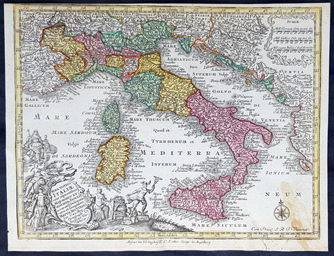
1744 Georg Mattaus Seutter Antique Map of Italy, Sicily Sardinia, Corsica
- Title : Nova Totius Italiae.......a Matth. Seutteri...T C Lotter, Geogr.
- Ref #: 93396
- Size: 11in x 8 1/2in (280mm x 215mm)
- Date : 1744
- Condition: (A+) Fine Condition
Description:
This beautifully hand coloured original copper-plate engraved antique map of Italy was engraved by Tobias Lotter and was published in the 1744 edition of GM Seutters Atlas Minor Prae cipua Orbis Terrarum Imperia Regna et Provincias...., Augsburg, Germany.
General Definitions:
Paper thickness and quality: - Heavy and stable
Paper color : - off white
Age of map color: - Early
Colors used: - Yellow, green, blue, pink
General color appearance: - Authentic
Paper size: - 11in x 8 1/2in (280mm x 215mm)
Plate size: - 10 1/2in x 8in (265mm x 205mm)
Margins: - Min 1/4in (5mm)
Imperfections:
Margins: - None
Plate area: - None
Verso: - Light age toning right bottom corner
Background:
Atlas Minor was a series of beautiful maps of all parts of the world. Georg Matthäus Seutter was one of the most and important of the German cartographers of the 18th century, being appointed as the Geographer to the Imperial Court. His son, Albrecht Carl, joined Matthäus and eventually inherited the business. The maps from Atlas Minor were drawn by the two Seutters and engraved by Tobias Conrad Lotte. These maps are highly detailed and engraved with a bold hand with equally strong original hand color in the body of the map as was the 18th century German style. The cartouches were left uncolored in order to emphasize the elaborately detailed illustrations for which German maps are especially prized. These are some of the most decorative and interesting maps of the eighteenth century.
1574 Braun & Hogenberg Antique Map View of Wesel North Rhine-Westphalia, Germany
- Title : Hermannus Hammelman Wesalia in Ducatu Cliuensi
- Size: 21in x 16in (545mm x 410mm)
- Condition: (A+) Fine Condition
- Date : 1574
- Ref #: 81068-1
Description:
This original copper-plate engraved antique map, plan, a birds eye view of city of Wesel in North Rhine-Westphalia, in western Germany was published by Georg Braun & Frans Hogenberg for the 1574 atlas of town plans Civiates Orbis Terrarum intended as a companion to Abraham Ortelius master Atlas Theatrum Orbis Terrarum published in 1570.
General Definitions:
Paper thickness and quality: - Heavy and stable
Paper color : - off white
Age of map color: -
Colors used: -
General color appearance: -
Paper size: - 21in x 16in (545mm x 410mm)
Plate size: - 19in x 13 1/2in (480mm x 340mm)
Margins: - Min 1in (25mm)
Imperfections:
Margins: - None
Plate area: - None
Verso: - None
Background:
Wesel is a city in North Rhine-Westphalia, Germany. It is the capital of the Wesel district.
The city originated from a Franconian manor that was first recorded in the 8th century. In the 12th century, the Duke of Clèves took possession of Wesel. The city became a member of the Hanseatic League during the 15th century. Wesel was second only to Cologne in the lower Rhine region as an entrepôt. It was an important commercial centre: a clearing station for the trans-shipment and trading of goods.
In 1590 the Spanish captured Wesel after a four-year siege. The city changed hands between the Dutch and Spanish several times during the Eighty Years War. In 1672 a French force under Louis II de Bourbon, Prince de Condé captured the city. Wesel was inherited by the Hohenzollerns of the Margraviate of Brandenburg in 1609 but they were unable to take control of Wesel until the Treaty of Nijmegen in 1678. Although the city had been heavily fortified the Prussians evacuated the city during the Seven Years War and it was occupied by the French. It was returned to Prussia at the end of the war. Friedrich Wilhelm von Dossow was the Prussian Governor of Wesel during the 18th century. Wesel was ceded to the French in 1805 under the treaty of Schönbrunn. The French heavily fortified the city constructing a rectangular fort called the Citadelle Napoleon at Büderich and the Citadelle Bonaparte on an island in the Rhine off Wesel. Though blockaded by the Allies in 1813 the city remained in French hands until after the Battle of Waterloo. After the Napoleonic Wars of the early 19th century, the city became part of the Prussian Rhine Province and the Citadelle Napoleon was renamed Fort Blücher.
1756 J B D Anville Large Antique Map Greece, Crete, Corfu, Aegean Isles Turkey
- Title : Les Cotes De La Grece et L Archipel...MDCCLVI
- Size: 34in x 23in (865m x 585mm)
- Condition: (A) Very Good Condition
- Date : 1756
- Ref #: 21996
Description:
This large original copper-plate engraved antique map of Greece, Crete & the Greek Islands by Jean Baptiste Bourguignon D\'Anville was engraved in 1756 - dated in the tile cartouche - and was published in Jean-Baptiste Bourguinon D\'Anvilles large elephant folio atlas Atlas Generale. (Ref: Tooley, M&B)
General Definitions:
Paper thickness and quality: - Heavy and stable
Paper color : - off white
Age of map color: - Early
Colors used: - Yellow, pink, green, blue
General color appearance: - Authentic
Paper size: - 34in x 23in (865m x 585mm)
Plate size: - 29in x 22in (735mm x 560mm)
Margins: - Min 1/2in (12mm)
Imperfections:
Margins: - None
Plate area: - None
Verso: - None
Background:
While most of mainland Greece and the Aegean islands was under Ottoman control by the end of the 15th century, Cyprus and Crete remained Venetian territory and did not fall to the Ottomans until 1571 and 1670 respectively. The only part of the Greek-speaking world that escaped long-term Ottoman rule was the Ionian Islands, which remained Venetian until their capture by the First French Republic in 1797, then passed to the United Kingdom in 1809 until their unification with Greece in 1864.
While some Greeks in the Ionian Islands and Constantinople lived in prosperity, and Greeks of Constantinople (Phanariotes) achieved positions of power within the Ottoman administration, much of the population of mainland Greece suffered the economic consequences of the Ottoman conquest. Heavy taxes were enforced, and in later years the Ottoman Empire enacted a policy of creation of hereditary estates, effectively turning the rural Greek populations into serfs.
The Greek Orthodox Church and the Ecumenical Patriarchate of Constantinople were considered by the Ottoman governments as the ruling authorities of the entire Orthodox Christian population of the Ottoman Empire, whether ethnically Greek or not. Although the Ottoman state did not force non-Muslims to convert to Islam, Christians faced several types of discrimination intended to highlight their inferior status in the Ottoman Empire. Discrimination against Christians, particularly when combined with harsh treatment by local Ottoman authorities, led to conversions to Islam, if only superficially. In the 19th century, many crypto-Christians returned to their old religious allegiance.
The nature of Ottoman administration of Greece varied, though it was invariably arbitrary and often harsh. Some cities had governors appointed by the Sultan, while others (like Athens) were self-governed municipalities. Mountainous regions in the interior and many islands remained effectively autonomous from the central Ottoman state for many centuries.
When military conflicts broke out between the Ottoman Empire and other states, Greeks usually took up arms against the Ottomans, with few exceptions. Prior to the Greek Revolution of 1821, there had been a number of wars which saw Greeks fight against the Ottomans, such as the Greek participation in the Battle of Lepanto in 1571, the Epirus peasants\' revolts of 1600–1601 (led by the Orthodox bishop Dionysios Skylosophos), the Morean War of 1684–1699, and the Russian-instigated Orlov Revolt in 1770, which aimed at breaking up the Ottoman Empire in favor of Russian interests.[89][page needed] These uprisings were put down by the Ottomans with great bloodshed. On the other side, many Greeks were conscripted as Ottoman citizens to serve in the Ottoman army (and especially the Ottoman navy), while also the Ecumenical Patriarchate of Constantinople, responsible for the Orthodox, remained in general loyal to the empire.
The 16th and 17th centuries are regarded as something of a dark age in Greek history, with the prospect of overthrowing Ottoman rule appearing remote with only the Ionian islands remaining free of Turkish domination. Corfu withstood three major sieges in 1537, 1571 and 1716 all of which resulted in the repulsion of the Ottomans. However, in the 18th century, due to their mastery of shipping and commerce, a wealthy and dispersed Greek merchant class arose. These merchants came to dominate trade within the Ottoman Empire, establishing communities throughout the Mediterranean, the Balkans, and Western Europe. Though the Ottoman conquest had cut Greece off from significant European intellectual movements such as the Reformation and the Enlightenment, these ideas together with the ideals of the French Revolution and romantic nationalism began to penetrate the Greek world via the mercantile diaspora. In the late 18th century, Rigas Feraios, the first revolutionary to envision an independent Greek state, published a series of documents relating to Greek independence, including but not limited to a national anthem and the first detailed map of Greece, in Vienna, and was murdered by Ottoman agents in 1798.
1757 Robert De Vaugondy Large Antique Map Spain, Portugal & The Balearic Islands
- Title : 1757 Robert De Vaugondy Large Antique Map Spain, Portugal & The Balearic Islands
- Size: 26in x 20in (660mm x 510mm)
- Condition: (A+) Fine Condition
- Date : 1757
- Ref #: 41585
Description:
This magnificent hand coloured original copper-plate engraved antique map of Spain, Portugal & The Balearic Islands by Robert De Vaugondy was published in the 1757 edition of De Vaugondys famous The Atlas Universel
General Definitions:
Paper thickness and quality: - Heavy and stable
Paper color : - off white
Age of map color: - Original & later
Colors used: - Blue, pink, red, green, yellow
General color appearance: - Authentic
Paper size: - 26in x 20in (660mm x 510mm)
Plate size: - 21in x 19 1/2in (535mm x 495mm)
Margins: - Min 1/4in (5mm)
Imperfections:
Margins: - None
Plate area: - None
Verso: - None
Background:
Many of the original charts and maps drawn by the first Portuguese and Spanish navigators have survived for the very good reason that, on completion of their voyages, pilots were obliged to hand over their manuscript notes to the Casa da India (founded 1504) in Lisbon or to the equivalent Casa de Contrataci6n de las Indias (founded 1504) in Seville. The clear intention was to maintain secrecy over new discoveries and control over the distribution of cartographic material, not always successfully, as it happened; pilots and navigators seem to have changed allegiance with impunity and, in consequence, many of the earliest and most informative charts were compiled as far away as Genoa, Venice, Florence and Ancona, presumably from sources outside the Portuguese and Spanish \\\'Casas\\\'.It is apparent that few manuscripts reached the printing stage and, indeed, are so rare that any study of them must be regarded as a specialist subject. (Ref Tooley M&B)
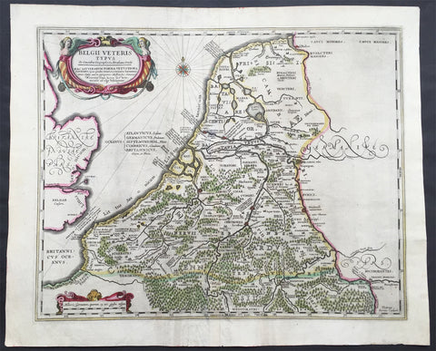
1638 Jansson Large Antique Map of The Netherlands & Belgium
- Title : Belgii Veteris Typus...Abrahami Ortelii...Petrus Karius
- Ref #: 61036
- Size: 21 1/2in x 17 1/2in (545mm x 445mm)
- Date : 1638
- Condition: (A) Very Good Condition
Description:
This large beautifully hand coloured original antique map of The Netherlands & Belgium was engraved by Peter Karius and was published in the 1638 Latin edition of Mercator's Atlas published by Henricus Hondius and Jan Jansson. (Ref: Koeman; M&B; Tooley)
Condition Report:
Paper thickness and quality: - Heavy and stable
Paper color: - off white
Age of map color: - Original
Colors used: - Yellow, pink, green
General color appearance: - Authentic
Paper size: - 21 1/2in x 17 1/2in (545mm x 445mm)
Plate size: - 19in x 15 1/2in (480mm x 395mm)
Margins: - Min 1in (25mm)
Imperfections:
Margins: - Light creasing in bottom margin
Plate area: - Centerfold Re-joined
Verso: - Soiling
1623 Mercator Hondius Antique Map of Morea - the Greek Peloponnesus, Greece
- Title : Morea olim Piloponnesus
- Ref #: 35489
- Size: 21 1/2in x 17in (545mm x 430mm)
- Date : 1623
- Condition: (A+) Fine Condition
Description:
This beautifully hand coloured original antique map of Morea - the Greek Peloponnesus - was published in the 1623 ofMercators Atlas published by Henricus Hondius and Jan Jansson.
These maps, published in the later editions of Mercators atlas, are derived from the original maps drawn and engraved by Gerard Mercator in the mid to late 16th century, published by his son Rumold as an atlas, after his death, in 1595. After two editions the plates were purchased by Jodocus Hondius in 1604 and continued to be published until the mid 1630's when the plates were re-engraved and updated by Jan Jansson and Henricus Hondius.
Condition Report
Paper thickness and quality: - Heavy and stable
Paper color: - off white
Age of map color: - Original
Colors used: - Red, yellow, green
General color appearance: - Authentic
Paper size: - 21 1/2in x 17in (545mm x 430mm)
Plate size: - 16 1/2in x 13 1/2in (420mm x 345mm)
Margins: - Min 1in (25mm)
Imperfections:
Margins: - Light age toning
Plate area: - Light wear along centerfold
Verso: - Light colour bleed
1575 Braun & Hogenberg Antique Print Sneek Dokkum Ylst Frisia Sloten Netherlands
- Title : Sneecha, vulgo Sneeck Frisiae Occidentalis Oppidum. - Doccum - Sloten - Ylsta
- Ref #: 30261
- Size: 21in x 16in (535mm x 410mm)
- Date : 1575
- Condition: (A+) Fine Condition
Description:
This fine beautifully hand coloured original antique map a birds-eye view of the towns of Sneek, Dokkum, Ylst and Sloten in Frisia, the Netherlands was published by Georg Braun & Frans Hogenberg for the 1575 atlas of town plans Civiates Orbis Terrarum Vol II (1572-1612) intended as a companion to Abraham Ortelius's master Atlas Theatrum Orbis Terrarum published in 1570.
Background of Civitates Orbis Terrarum
The first volume of the Civitates Orbis Terrarum was published in Cologne in 1572. The sixth and the final volume appeared in 1617.
This great city atlas, edited by Georg Braun and largely engraved by Franz Hogenberg, eventually contained 546 prospects, bird-eye views and map views of cities from all over the world. Braun (1541-1622), a cleric of Cologne, was the principal editor of the work, and was greatly assisted in his project by the close, and continued interest of Abraham Ortelius, whose Theatrum Orbis Terrarum of 1570 was, as a systematic and comprehensive collection of maps of uniform style, the first true atlas.
For a variety of reasons town plans were comparatively latecomers in the long history of cartography. Few cities in Europe in the middle ages had more than 20,00 inhabitants and even London in the late Elizabethan period had only 100-150,000 people which in itself was probably 10 times that of any other English city. The Nuremberg Chronicle in 1493 included one of the first town views of Jerusalem, thereafter, for most of the sixteenth century, German cartographers led the way in producing town plans in a modern sense. In 1544 Sebastian Munster issued in Basle his Cosmographia containing roughly sixty-six plans and views, some in the plan form, but many in the old panorama or birds eye view. (Ref: Tooley; M&B)
Condition Report:
Paper thickness and quality: - Heavy and stable
Paper color: - off white
Age of map color: - Early
Colors used: - Green, blue, red, yellow
General color appearance: - Authentic
Paper size: - 21in x 16in (535mm x 410mm)
Plate size: - 16 1/2in x 14in (420mm x 355mm)
Margins: - Min 1in (25mm)
Imperfections:
Margins: - Light soiling in margins
Plate area: - None
Verso: - None
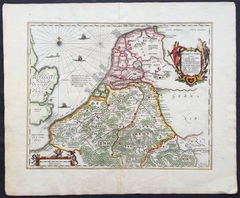
1652 Jansson Large Old, Antique Map of The Netherlands
- Title : Belgii Veteris
- Ref #: 80696
- Size: 24in x 19 1/2in (610mm x 495mm)
- Date : 1652
- Condition: (A+) Fine Condition
Description:
This beautifully engraved hand coloured original antique map of Belgium & the Netherlands was published by Jan Jansson in the 1652 edition of Accuratissima Orbis Antiqui Delineatio.
The cartographical information from this map was borrowed from the Abraham Ortelius map Daciarum Moesiarum first published inParergon in 1595. (Ref: Koeman; Tooley)
General Description:
Paper thickness and quality: - Heavy and stable
Paper color: - off white
Age of map color: - Later
Colors used: - Green, red, orange, yellow, blue
General color appearance: - Authentic and beautiful
Paper size: - 24in x 19 1/2in (610mm x 495mm)
Plate size: - 19in x 14 1/2in (485mm x 370mm)
Margins: - Min 1in (25mm)
Imperfections:
Margins: - None
Plate area: - None
Verso: - None
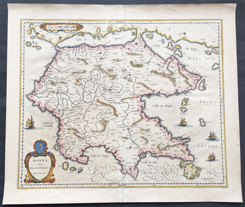
1640 Blaeu Antique Map of the Peloponnese or Morea Peninsula, Greece
- Title : Morea olim Peloponnesus..Guil. Blaeu exc.
- Date : 1640
- Condition: (A+) Fine Condition
- Ref: 70300
- Size: 22in x 19in (560mm x 485mm)
Description:
This beautifully engraved hand coloured original 1st edition antique map of the southern Greek peninsular of the Peloponnesusor Morea was published in the 1640 Latin edition of Joan Blaeu's Atlas Nouvs.
The peninsula has been inhabited since prehistoric times. Its modern name derives from ancient Greek mythology, specifically the legend of the hero Pelops who was said to have conquered the entire region. The namePeloponnesos means "Island of Pelops". During the Middle Ages, the peninsula was known as the Morea. According to folk etymology, this is because the Crusaders found it densely planted with mulberry trees (Greek: moreai) used by the flourishing silk industry.
Blaeu is one of the most revered map makers of all time and it is easy to see why in this beautiful original map. The high level of the topographical detail, the quality of the paper, the artistic professionalism of the engraving and the beauty of the original hand colouring combine to produce a work of art that is both functional and of exceptional beauty. (Ref: Koeman; M&B)
General Description:
Paper thickness and quality: - Heavy and stable
Paper color: - off white
Age of map color: - Original
Colors used: - Yellow, pink, red, blue, green
General color appearance: - Authentic
Paper size: - 22in x 19in (560mm x 485mm)
Plate size: - 22in x 19in (560mm x 485mm)
Margins: - Min 1in (25mm)
Imperfections:
Margins: - Bottom centerfold re-joined slight separation
Plate area: - Light brush marks across page
Verso: - Light brush marks across page