- Home
- Globes
Globes (1)
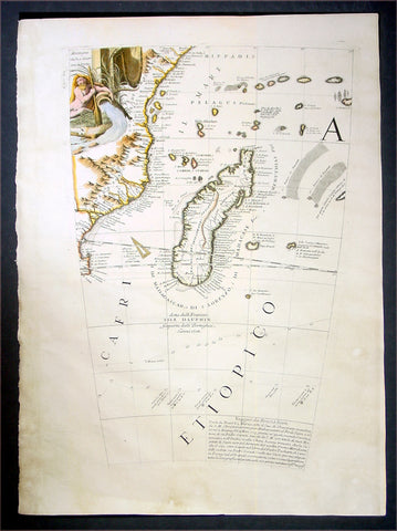
1696 Coronelli Antique Map Globe Gore Section of SE Africa & Madagascar
Antique Map
- Title : Cafri Etiopico
- Date : 1696
- Condition: (A+) Fine Condition
- Ref: 30781
- Size: 19 1/2in x 14in (495mm x 355mm)
Description:
This is a rare opportunity to acquire one of the hand coloured original antique Globe Gores of Madagascar & SE Africa by Vincenzo Coronelli published in 1696.
The copper-plates for these gores were originally engraved in 1688 by Coronelli for the construction of the large 42in (110cm) terrestrial globe.
In 1696 Coronelli published all his gores - from the 2in to the 42 in - in an atlas, Libero dei Globi, part of the great series of atlases,Atlante Veneto. Libero dei Globi was published by Coronelli to ensure his work was available to a wider audience, as very few could afford travel to Venice, Rome or Paris to view his completed globes.
Background:
In the early 1680’s Vincenzo Coronelli constructed two vast 15ft diameter terrestrial & celestial globes for Louis XIV of France. These were meticulously hand drawn & engraved. Such was the admiration of these Globes that in 1688 Coronelli began the engraving & publication of Globe Gores for the construction of two 110cm (42in) terrestrial & celestial globes.
Coronellis claim to have produced the best globes of any age was exemplified by the high demand and purchase of the globes by various institutions & cities within Europe. Yet many scholars still did not have the opportunity to visit Paris, London, Rome or Venice to view them and so Coronelli devised his famous atlas Libero dei Globi the first atlas of globe gores ever produced. The Libroformed part of a great series of atlases by Coronelli, the Atlante Veneto, in which Coronelli was able to combine the two cartographic art forms in which he excelled, maps & globes.
The engraving of the gores was of the highest standard with neat contrasting lettering and five large cartouches of a singular grace and elegance. One cartouche situated below Australia carries a portrait of the author and Pope Alexander VI.
Some of the more interesting features contained within the Gores are the recording of recent French explorations in North America, such as La Salles journey to the mouth of the Mississippi in 1681-87 & the French possessions within North America. Elsewhere the Caspian Sea is drawn closer to its modern shape, the Nile in Africa is shown without its fictitious source and the Blue Nile is shown correctly from a large lake in Ethiopia. The tracks of Le Maire crossing of the Pacific in 1616 are marked, as is the voyage of Chaumont to Siam in 1685-6. There are an unusual number of legends, all explanatory and informative along with many vignettes of ships and fishing scenes throughout the globe.
Coronelli was one of the finest engravers & cartographers of any era, producing some of the most stunning work ever seen. These Globe Gores are no exception. Coronelli was a master craftsman with an eye for detail. You can feel the uncompromising accuracy & passion in his work when you study his maps & globes.
These globe gores are scarce, with only a few sales records from the last 25 years. Similarly there is very little choice currently on the market. This scarcity ensures ongoing value and future appreciation. (Ref: Shirley 538; Tooley; Dr. Helen Wallis The Map Collector Dec 1980;Armao, Ermanno. Vincenzo Coronelli Cenni sull'uomo e la sua Vita Catalogo... Bibliopolis, Florence pp.130-134)
General Description:
Paper thickness and quality: - Heavy and stable
Paper color: - white
Age of map color: - Early
Colors used: - Yellow, green, blue
General color appearance: - Authentic
Paper size: - 19 1/2in x 14in (495mm x 355mm)
Plate size: - 19in x 11 1/2in (485mm x 290mm)
Margins: - min. 1/2in (12mm)
Imperfections:
Margins: - Light age toning
Plate area: - None
Verso: - None