Recent Acquisitions (295)
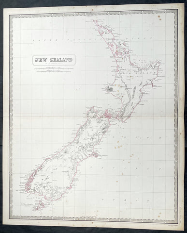
1856 A K Johnston Large Antique Map of New Zealand
- Title : New Zealand by A K Johnston
- Date : 1856
- Condition: (A+) Fine Condition
- Ref: 93438
- Size: 25in x 21 1/2in (635mm x 545mm)
Description:
This original large hand coloured steel plate engraved antique map of New Zealand was published by A K Johnston in the 1856 edition of his National atlas of historical, commercial, and political geography.
General Definitions:
Paper thickness and quality: - Heavy and stable
Paper color : - off white
Age of map color: - Original
Colors used: - Yellow, green, blue, pink
General color appearance: - Authentic
Paper size: - 25in x 21 1/2in (635mm x 545mm)
Plate size: - 25in x 21 1/2in (635mm x 545mm)
Margins: - Min 1/2in (12mm)
Imperfections:
Margins: - Light spotting
Plate area: - Light spotting
Verso: - Light spotting
Background:
The first printed chart of New Zealand.
New Zealand (or Aotearoa, as the Maori call it) had been first encountered by Europeans in the early 1640s, when Dutch explorer Abel Tasman named the land Nieuw Zeeland after the Dutch province. Importantly, Tasman only sailed up the west coast of the North Island and had little notion as to the nature of the islands or their broader geographical context. A small number of Tasmans place names were preserved by Cook (and remain in place to this day), including Cape Maria van Diemen (the northernmost point of the North Island) and the Three Kings islets, where Cook and his men celebrated the Christmas of 1769-the first Europeans to visit the islands for nearly 130 years.
Captain James Cook (1728-1779) is considered to be the greatest explorer of the eighteenth century and was the finest maritime cartographer of the Age of Enlightenment. Having first worked on coal colliers and then distinguished himself as a surveyor in Eastern Canada, in 1768 he became the British Admiraltys choice to lead an unprecedented voyage of discovery. The central impetus for the expedition was to observe the Transit of Venus from Tahiti and then to proceed to explore Terra Australis Incognita, the supposedly rich southern continent. Whereas the first part of the voyage was to be conducted under the auspices of international scientific cooperation, the second part was entirely clandestine and was only communicated to Cook via Secret Instructions to be opened once at sea.
Cooks party left Plymouth in August 1768 aboard the converted coal collier HMS Endeavor and proceeded to Tahiti by way of Cape Horn. They arrived in time to observe the Transit of Venus, which occurred June 3, 1769. Cook then proceeded towards New Zealand, to the coordinates recorded by Tasman. As New Zealand was quite conceivably part of Terra Australis, it was Cooks intention to carefully explore and map the region.
On October 6, 1769, the Endeavor sighted the North Island (Te Ika a Maui) at Turanga Nui, which Cook renamed Poverty Bay. He and his crew had arrived on the opposite shore to where Tasman had met the island. Cook proceeded to the South Island (Te Wai Pounamu), carefully mapping both landmasses with a running survey. He used soundings, visual observations, and triangulation regulated by astronomical observations to create his manuscript charts.
Despite being constantly buffeted by wind and rain, and after having some hostile relations with the Maori that resulted in Maori deaths, Cook and his crew managed to circumnavigate both the North and South Islands, proving that they were separate islands divided by the Cook Strait. They also proved the islands were not connected to any southern continent. On March 31, 1770, Cook wrote in his journal that the Endeavours voyage:
…must be allowed to have set a side the most, if not all, the arguments and proofs that have been advanced by different Authors to prove that there must be a Southern Continent; I mean to the northward of 40 degrees South, for what may lay to the Southward of that Latitude I know not (Cook, Journals I, 290).
The Endeavor left New Zealand at Cape Farewell, sailing west towards Australia, where Cooks crew would become the first Europeans to explore that region. In total, they had surveyed over 2,400 miles of New Zealand coastline in six months.
Upon the Endeavours return to England in July 1771, Cook became a national hero. He would go on to lead two further voyages that would succeed in illuminating most of the Pacific Ocean to European eyes. On the second expedition, Cook would put to rest the myth of a southern continent. On the third, he kick started the fur trade in the Pacific Northwest of North America while searching for the Northwest Passage. He was killed by Hawaiians at Kealakekua Bay in 1779.
The chart and its publication
Cook returned to England with over 300 manuscript charts and coastal views. The original manuscript chart of New Zealand is now held by the British Library (Add MS 7085, f. 16-7). The chart was drawn, at least in part, by Isaac Smith (1752-1831), a draftsman of considerable skill who worked with Cook in Newfoundland, sailed on the Endeavour and Cooks second voyage, and was related to Cooks wife. Of the New Zealand chart, Cook wrote:
The Chart which I have drawn will best point out the figure and extent of these Islands…beginning at Cape Palliser and proceed round Aehei no mouwe (North Island) by the East Cape &ca. The Coast between these two Capes I believe to be laid down pretty accurate both in its figure and the Course and distance from point to point. The oppertunities I had and the methods I made use on to obtain these requesites were such as could hardly admit of an error… some few places however must be excepted and these are very doubtfull …(Cook, Journals I, 275-6)
The overall delineation is impressively accurate, correctly capturing many of the bays and promontories, and making insightful observations of the interior. Many of the names given by Cook survive to this day, including the Alps, (the great mountain chain of the South Island), Mount Egmont (the volcano on the North Island, also known as Mount Taranaki), the Bay of Islands, the Bay of Plenty, Hawkes Bay, and most intriguingly, Cape Kidnappers (a point on the North Island where Maori warriors attempted to abduct a member of the Endeavors crew).
There are a few errors, conspicuous only because of the otherwise superb accuracy of the chart. Notably, Cooks Bankes Island is in fact a peninsula, part of the South Island. Further south, what looks like a possible peninsula is actually Stewart Island, with the Isle Solander to the west. Also, some portions of coast line remain un-surveyed due to adverse conditions or distraction. For example, the portion of coastline near Bankes Island is but a dotted line because Lieutenant Gore had thought he sighted land to the southeast. Upon sailing toward it, the promontory proved to be clouds. Despite such mistakes, the chart is remarkably thorough.
The present chart was printed as part of the official account of Cooks first voyage, which was edited by the literary critic John Hawkesworth and underwritten by the British Admiralty. An Account of the Voyages undertaken by the order of His Present Majesty for making Discoveries in the Southern Hemisphere… (London: W. Strahan and T. Cadell, 1773) recounted the voyages not only of Cook, but of Byron, Wallis, and Carteret who had also ventured to the Pacific for the Royal Navy earlier in the 1760s. It was engraved by John Abraham Bayly (fl. 1755-1794), a London-based engraver who specialized in cartographic work.
In 1816, the British Hydrographic Office began to reprint the map for its vessels. The chart was continuously consulted into the twentieth century. Due to this longevity, its extraordinary origins, and its important place in the founding of New Zealand as a British colony, Cooks chart is considered to be the most important single map in the history of New Zealand. Due to the complexity of the assignment and the great accuracy of the survey, it is also considered to be one of Cooks very finest maps, and one of the truly great achievements of Enlightenment cartography.
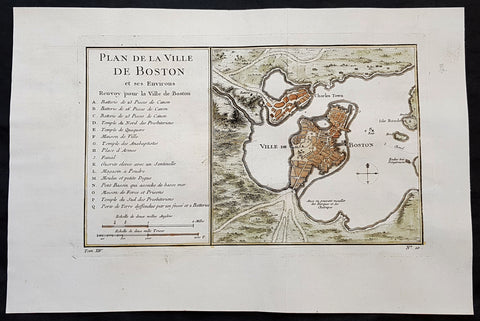
1756 J N Bellin Antique Map of The City of Boston & Charlestown
- Title : Plan de la Ville De Boston et ses Environs
- Ref #: 93417
- Size: 14 1/2in x 9 1/2in (350mm x 240mm)
- Date : 1756
- Condition: (A+) Fine Condition
Description:
This original hand coloured copper plate engraved antique map of Boston and surrounding areas - one of the earliest obtainable maps of the city - by Jacques Nicholas Bellin in 1756 - was published in the French edition of Antoine-François Prevosts 20 volume L Histoire Generale des Voyages published by Pierre de Hondt in the Hague between 1747 & 1785.
Beautiful map with great street and building detail in both Boston and Charlestown, showing parts of Ronde Isle and the mainland. Important buildings and areas identified in an idex at the left of the map. Including three cannon batteries, the Presbyterian Church, the Quaker temple, the Anabaptist Church, the City Hall, the Armory, Faneuil Hall (Spelled Fanal), etc. (Ref: Tooley; M&B)
General Definitions:
Paper thickness and quality: - Heavy and stable
Paper color : - off white
Age of map color: - Early
Colors used: - Yellow, green, blue, pink
General color appearance: - Authentic
Paper size: - 14 1/2in x 9 1/2in (350mm x 240mm)
Plate size: - 11 1/2in x 7 1/2in (285mm x 190mm)
Margins: - Min 1in (25mm)
Imperfections:
Margins: - None
Plate area: - Folds as issued
Verso: - None
Background:
Boston is the capital city and most populous municipality of the Commonwealth of Massachusetts in the United States.
Boston is one of the oldest cities in the United States, founded on the Shawmut Peninsula in 1630 by Puritan settlers from England. It was the scene of several key events of the American Revolution, such as the Boston Massacre, the Boston Tea Party, the Battle of Bunker Hill, and the Siege of Boston. Upon U.S. independence from Great Britain, it continued to be an important port and manufacturing hub as well as a center for education and culture.
In the 1820s, Boston\\\\\\\\\\\\\\\'s population grew rapidly, and the city\\\\\\\\\\\\\\\'s ethnic composition changed dramatically with the first wave of European immigrants. Irish immigrants dominated the first wave of newcomers during this period, especially following the Irish Potato Famine; by 1850, about 35,000 Irish lived in Boston. In the latter half of the 19th century, the city saw increasing numbers of Irish, Germans, Lebanese, Syrians, French Canadians, and Russian and Polish Jews settling in the city. By the end of the 19th century, Boston\\\\\\\\\\\\\\\'s core neighborhoods had become enclaves of ethnically distinct immigrants. Italians inhabited the North End, Irish dominated South Boston and Charlestown, and Russian Jews lived in the West End. Irish and Italian immigrants brought with them Roman Catholicism. Currently, Catholics make up Boston\\\\\\\\\\\\\\\'s largest religious community and the Irish have played a major role in Boston politics since the early 20th century; prominent figures include the Kennedys, Tip O\\\\\\\\\\\\\\\'Neill, and John F. Fitzgerald.
Between 1631 and 1890, the city tripled its area through land reclamation by filling in marshes, mud flats, and gaps between wharves along the waterfront. The largest reclamation efforts took place during the 19th century; beginning in 1807, the crown of Beacon Hill was used to fill in a 50-acre mill pond that later became the Haymarket Square area. The present-day State House sits atop this lowered Beacon Hill. Reclamation projects in the middle of the century created significant parts of the South End, the West End, the Financial District, and Chinatown.
After the Great Boston Fire of 1872, workers used building rubble as landfill along the downtown waterfront. During the mid- to-late 19th century, workers filled almost 600 acres of brackish Charles River marshlands west of Boston Common with gravel brought by rail from the hills of Needham Heights. The city annexed the adjacent towns of South Boston (1804), East Boston (1836), Roxbury (1868), Dorchester (including present day Mattapan and a portion of South Boston) (1870), Brighton (including present day Allston) (1874), West Roxbury (including present day Jamaica Plain and Roslindale) (1874), Charlestown (1874), and Hyde Park (1912). Other proposals were unsuccessful for the annexation of Brookline, Cambridge and Chelsea.
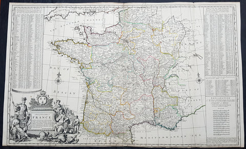
1720 Herman Moll Large Antique Map of France in Provinces - Pre Revolution
- Title : A New and Exact Map of France Divided into all its Provinces...by H Moll Geographer
- Ref #: 93416
- Size: 40in x 24 1/2in (1.010m x 625mm)
- Date : 1720
- Condition: (A+) Fine Condition
Description:
This very large beautifully hand coloured original copper-plate engraved antique map of France by Herman Moll was published in 1720 in the atlas The World Described, or a New and Correct Sett of Maps by John Bowles, Thomas Bowles, Philip Overton & John King of London.
In the 18th century many large-scale maps were published by the likes of John Senex and Herman Moll, this trend continued until the end of private mapping in the early 19th century when it was replaced by Ordnance Survey maps.
General Definitions:
Paper thickness and quality: - Heavy and stable
Paper color : - off white
Age of map color: - Early
Colors used: - Yellow, green, blue, pink
General color appearance: - Authentic
Paper size: - 40in x 24 1/2in (1.010m x 625mm)
Plate size: - 39 1/2in x 24in (1.00m x 620mm)
Margins: - Min 1/8in (3mm)
Imperfections:
Margins: - Bottom margin cropped to plate mark
Plate area: - Folds as issued
Verso: - Folds as issued
Background:
The Carolingian dynasty ruled France until 987, when Hugh Capet, Duke of France and Count of Paris, was crowned King of the Franks. His descendants—the Capetians, the House of Valois, and the House of Bourbon—progressively unified the country through wars and dynastic inheritance into the Kingdom of France, which was fully declared in 1190 by Philip II Augustus. The French nobility played a prominent role in most Crusades in order to restore Christian access to the Holy Land. French knights made up the bulk of the steady flow of reinforcements throughout the two-hundred-year span of the Crusades, in such a fashion that the Arabs uniformly referred to the crusaders as Franj caring little whether they really came from France. The French Crusaders also imported the French language into the Levant, making French the base of the lingua franca (litt. Frankish language) of the Crusader states. French knights also made up the majority in both the Hospital and the Temple orders. The latter, in particular, held numerous properties throughout France and by the 13th century were the principal bankers for the French crown, until Philip IV annihilated the order in 1307. The Albigensian Crusade was launched in 1209 to eliminate the heretical Cathars in the southwestern area of modern-day France. In the end, the Cathars were exterminated and the autonomous County of Toulouse was annexed into the crown lands of France. Later kings expanded their domain to cover over half of modern continental France, including most of the north, centre and west of France. Meanwhile, the royal authority became more and more assertive, centred on a hierarchically conceived society distinguishing nobility, clergy, and commoners.
From the 11th century, the House of Plantagenet, the rulers of the County of Anjou, succeeded in establishing its dominion over the surrounding provinces of Maine and Touraine, then progressively built an empire that spanned from England to the Pyrenees and covering half of modern France. Tensions between the kingdom of France and the Plantagenet empire would last a hundred years, until Philip Augustus of France conquered between 1202 and 1214 most of the continental possessions of the empire, leaving England and Aquitaine to the Plantagenets. Following the Battle of Bouvines, the Angevin court retreated to England, but persistent Capetian–Plantagenet rivalry would paved the way for another conflict.
Charles IV the Fair died without an heir in 1328. Under the rules of the Salic law the crown of France could not pass to a woman nor could the line of kingship pass through the female line. Accordingly, the crown passed to Philip of Valois, a cousin of Charles, rather than through the female line to Charles nephew, Edward of Plantagenet, who would soon become Edward III of England. During the reign of Philip of Valois, the French monarchy reached the height of its medieval power. Philips seat on the throne was contested by Edward III of England and in 1337, on the eve of the first wave of the Black Death, England and France went to war in what would become known as the Hundred Years War. The exact boundaries changed greatly with time, but French landholdings of the English Kings remained extensive for decades. With charismatic leaders, such as Joan of Arc and La Hire, strong French counterattacks won back English continental territories. Like the rest of Europe, France was struck by the Black Death; half of the 17 million population of France died.
The French Renaissance saw a spectacular cultural development and the first standardisation of the French language, which would become the official language of France and the language of Europes aristocracy. It also saw a long set of wars, known as the Italian Wars, between France and the House of Habsburg. French explorers, such as Jacques Cartier or Samuel de Champlain, claimed lands in the Americas for France, paving the way for the expansion of the First French colonial empire. The rise of Protestantism in Europe led France to a civil war known as the French Wars of Religion, where, in the most notorious incident, thousands of Huguenots were murdered in the St. Bartholomews Day massacre of 1572. The Wars of Religion were ended by Henry IVs Edict of Nantes, which granted some freedom of religion to the Huguenots. Spanish troops, the terror of Western Europe, assisted the Catholic side during the Wars of Religion in 1589–1594, and invaded northern France in 1597; after some skirmishing in the 1620s and 1630s, Spain and France returned to all-out war between 1635 and 1659. The war cost France 300,000 casualties.
Under Louis XIII, the energetic Cardinal Richelieu promoted the centralisation of the state and reinforced the royal power by disarming domestic power holders in the 1620s. He systematically destroyed castles of defiant lords and denounced the use of private violence (dueling, carrying weapons, and maintaining private army). By the end of 1620s, Richelieu established the royal monopoly of force as the doctrine. During Louis XIVs minority and the regency of Queen Anne and Cardinal Mazarin, a period of trouble known as the Fronde occurred in France. This rebellion was driven by the great feudal lords and sovereign courts as a reaction to the rise of royal absolute power in France.
The monarchy reached its peak during the 17th century and the reign of Louis XIV. By turning powerful feudal lords into courtiers at the Palace of Versailles, Louis XIVs personal power became unchallenged. Remembered for his numerous wars, he made France the leading European power. France became the most populous country in Europe and had tremendous influence over European politics, economy, and culture. French became the most-used language in diplomacy, science, literature and international affairs, and remained so until the 20th century. France obtained many overseas possessions in the Americas, Africa and Asia. Louis XIV also revoked the Edict of Nantes, forcing thousands of Huguenots into exile.
Under Louis XV, Louis XIVs great-grandson, France lost New France and most of its Indian possessions after its defeat in the Seven Years War (1756–63). Its European territory kept growing, however, with notable acquisitions such as Lorraine (1766) and Corsica (1770). An unpopular king, Louis XVs weak rule, his ill-advised financial, political and military decisions – as well as the debauchery of his court– discredited the monarchy, which arguably paved the way for the French Revolution 15 years after his death.
Louis XVI, Louis XVs grandson, actively supported the Americans, who were seeking their independence from Great Britain (realised in the Treaty of Paris (1783)). The financial crisis aggravated by Frances involvement in the American Revolutionary War was one of many contributing factors to the French Revolution. Much of the Enlightenment occurred in French intellectual circles, and major scientific breakthroughs and inventions, such as the discovery of oxygen (1778) and the first hot air balloon carrying passengers (1783), were achieved by French scientists. French explorers, such as Bougainville and Lapérouse, took part in the voyages of scientific exploration through maritime expeditions around the globe. The Enlightenment philosophy, in which reason is advocated as the primary source for legitimacy and authority, undermined the power of and support for the monarchy and helped pave the way for the French Revolution.

1598 J Moretus & A Ortelius 1st Edition of The Peutinger Tables, Ancient Roman Empire Maps x 4
- Title : Tabula Peutingeriana. Tabula itineraria ex illustri Peutingerorum Bibliotheca quae Augusta Vindel. est. Beneficio Marco Velseri septemviri Augustani in lucem edita.
- Size: 22in x 20in (560mm x 510mm) each
- Condition: (A+) Fine Condition
- Date : 1598
- Ref #: 50519, 50520, 50521, 50522
Description:
For three decades, locating rare & unusual and maps has been one our main goals and I believe with the following maps we have reach a milestone. The following maps originate from the oldest direct linage of any maps we have offered, going back to the height of the Roman Empire. These are some of the rarest and most fascinating maps it has been my pleasure to offer.
In 1265 a Monk, in the German city of Colmar produced a hand written map, on parchment, of the imperial highways and cities of the ancient Roman world. When joined, the result was a scroll measuring 6.75m long & 34cm wide, covering an area from southeast England to present day Sri-Lanka. That map of 1265 was copied from an earlier 4th or 5th century map, itself copied from a 2nd century map that originated from a 1st century BC map from Marcus Vipsanius Agrippa, a Roman General & architect. When Agrippa died in 12BC his map was engraved in marble and displayed in the Porticus Vipsania in the Campus Agrippae area in Rome.
In 1494 the German Scholar, Conrad Celtes, discovered the Colmar scroll in a library, in the city of Worms. After his death in 1508, Celtes bequeathed the scroll to Konrad Peutinger, after whom the map is named. The scroll was kept in the Peutinger family until it was purchased by Prince Eugene of Savoy in 1714 and finally purchased for the Habsburg Imperial Court Library in Vienna, where it resides today.
As early as 1577 Abraham Ortelius, the Flemish cartographer, was aware of the existence of the Peutinger Tables, at that stage owned by Mark Welser. In 1591 Welser had two sections of the scroll printed by Aldus Manutius in Venice. Ortelius thought these inadequate and so commissioned the scroll engraved onto 8 separate plates . Ortelius supervised the engraving of the plates but did not live to see the results. In December 1598 the first edition of the 8 plates were printed individually, in limited numbers, by Johannes Moretus in Antwerp and are today amongst some of the rarest sets of maps available. To save space for printing in the first & second atlases in 1619 & 1624, two plates were printed per page, thus saving space. At that point a change was made to each plate, the engraving of a descriptive title at the bottom of each plate.
These maps we are offering are unique, being printed two per page but without the addition of the titles. So the conclusion we have come to is that these were prototypes printed to see if the printing of two plates per page were possible prior to the changes to the plates, making them unique.
We know that there were a total of 300 sets of these tables published in 1619 & 1624 atlases Theatrum Geographiae Veteris & Parergon , of which very few have survived. As for the 1598 edition, we do not know the number published or how many have survived but there is no doubt the number is very low in the single digits. Also I can find no record of sale for this original 1598 1st Moretus edition.
General Definitions:
Paper thickness and quality: - Heavy and stable
Paper color : - off white
Age of map color: -
Colors used: -
General color appearance: -
Paper size: - 22in x 20in (560mm x 510mm) each
Plate size: - 20 1/4in x 7 1/2in (505mm x 195mm) each
Margins: - Min 1in (25mm)
Imperfections:
Margins: - None
Plate area: - None
Verso: - None
Background:
Tabula Peutingerian also referred to as Peutingers Tabul or The Peutinger Table, is an illustrated itinerarium (ancient Roman road map) showing the layout of the cursus publicus, the road network of the Roman Empire. The map covers Europe, North Africa, and parts of Asia, including the Middle East, Persia, and India.
The map was found as a 13th-century parchment copy based on a document from the 4th or 5th century, that contained a copy of the world map, originally prepared by Marcus Vipsanius Agrippa a Roman general & architect active during the reign of the emperor Augustus (27 BC – AD 14). After Agrippas death in 12 BC, that map was engraved in marble and put on display in the Porticus Vipsania in the Campus Agrippae area in Rome, close to the Ara Pacis building.
The original Roman map, of which the 13th century parchment copy may be the only surviving copy, was last revised in the 4th or early 5th century. This is illustrated by the inclusion of the city of Constantinople, founded in 328, and the prominence of Ravenna, seat of the Western Roman Empire from 402 to 476, which suggests a fifth-century revision. The presence of certain cities of Germania Inferior that were destroyed in the mid-fifth century also provides proof or 4th or 5th century revision.
The surviving 13th century map itself was created by a monk in Colmar in modern-day eastern France in 1265. It is a parchment scroll, 0.34 metres (1 foot 1 inch) high and 6.75 metres (22.1 feet) long, assembled from eleven sections, a medieval reproduction of the original scroll.
The 13th century parchment map is very schematic, designed to give a practical overview of the road network, as opposed to an accurate representation of geographic features: the land masses shown are distorted, especially in the east–west direction. The map shows many Roman settlements and the roads connecting them, as well as other features such as rivers, mountains, forests and seas. The distances between settlements are also given. In total no fewer than 555 cities and 3,500 other place names are shown on the map. The three most important cities of the Roman Empire at the time – Rome, Constantinople and Antioch – are represented with special iconic decoration.
Besides the totality of the empire, the map also shows areas in the Near East, India and the Ganges, Sri Lanka (Insula Taprobane), and even an indication of China. It even shows a Temple to Augustus at Muziris (present day Kodungallur) on the modern-day Malabar Coast, one of the main ports for trade with the Roman Empire on the southwest coast of India. On the western end of the scroll, the absence of Morocco, the Iberian Peninsula, and the British Isles indicates that a twelfth original section has been lost in the surviving copy; the missing section was reconstructed in 1898 by Konrad Miller.
The map appears to be based on itineraries, lists of destinations along Roman roads, as the distances between points along the routes are indicated. Travellers would not have possessed anything so sophisticated as a modern map, but they needed to know what lay ahead of them on the road and how far. The Peutinger Table represents these roads as a series of stepped lines along which destinations have been marked in order of travel. The shape of the parchment pages accounts for the conventional rectangular layout. However, a rough similarity to the coordinates of Ptolemys earth-mapping gives some writers hope that some terrestrial representation was intended by the unknown original compilers.
The stages and cities are represented by hundreds of functional place symbols, used with discrimination from the simplest icon of a building with two towers to the elaborate individualized portraits of the three great cities. Some conclud that the semi-schematic, semi-pictorial symbols reproduce Roman cartographic conventions of the itineraria picta described by 4th-century writer Vegetius, of which this is the sole known testimony.
The 13th century copy map was discovered in a library in the city of Worms by German scholar Conrad Celtes in 1494, who was unable to publish his find before his death and bequeathed the map in 1508 to Konrad Peutinger, a German humanist and antiquarian in Augsburg, after whom the map is named. The Peutinger family kept possession of the map for more than two hundred years until it was sold in 1714. It then bounced between several royal and elite families until it was purchased by Prince Eugene of Savoy for 100 ducats; upon his death in 1737, it was purchased for the Habsburg Imperial Court Library in Vienna (Hofbibliothek). It is today conserved at the Austrian National Library at the Hofburg palace in Vienna.
The map was copied for Dutch cartographer Abraham Ortelius by Johannes Moretus and published separetly, shortly after his death, in 1598. The maps were not published in an atlas until 1619 by Petrus Bertius and again in the Ortelius Parageon in 1624.
A partial first edition was printed at Antwerp in 1591 (titled Fragmenta tabulæ antiquæ) , Johannes Moretus, printed the full Tabula in December 1598, in Antwerp. Johannes Janssonius published another version in Amsterdam, c. 1652.
In 1753 Franz Christoph von Scheyb published a copy, and in 1872 Konrad Miller, a German professor, was allowed to copy the map. Several publishing houses in Europe then made copies. In 1892 publishers Williams and Norgate published a copy in London, and in 1911 a sheet was added showing the reconstructed sections of the British Isles and the Iberian peninsula missing in the original.
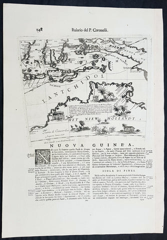
1692 Vincenzo Coronelli Antique Globe Gore Rare Map of Australia, Indonesia
- Title : Nuova Guinea
- Size: 19 1/2in x 14in (495mm x 360mm)
- Condition: (A+) Fine Condition
- Date : 1692
- Ref #: 30783
Description:
This finely engraved original antique map, a scarce Globe Gore map section - from Vincenzo Coronellis original 42in Globe of Australia, New Guinea and parts of the Islands of Indonesia - one of the earliest detailed maps of Australia - was published by Vincenzo Maria Coronelli in the 1696 Venice edition of Isolario dell Atlante Veneto.
To my mind Coronellis maps are some of the most beautifully engraved maps of the 17th century and the epitome of these are his Globe Gores.
In 1696 Coronelli published all his globe gores - from the 2in to the 42 in Globes - in an atlas, Libero dei Globi, part of the great series of atlases, Isolario dell Atlante Veneto that was published by Coronelli to ensure his work was available to a wider audience, as very few could afford travel to Venice, Rome or Paris to view his completed globes.
General Definitions:
Paper thickness and quality: - Heavy and stable
Paper color : - off white
Age of map color: -
Colors used: -
General color appearance: -
Paper size: - 19 1/2in x 14in (495mm x 360mm)
Plate size: - 11 1/2in x 9 1/2in (280mm x 235mm)
Margins: - Min 1in (25mm)
Imperfections:
Margins: - None
Plate area: - None
Verso: - None
Background:
The original globe gores for the 42in Terrestrial & Celestial Globe were printed on 12 full length sheets - with two polar calottes - in 1688.
To help fit into Coronellis future publications of Atlante Veneto, Libro dei Globi and Isolario dell Atlante Veneto the gore sheets were re-issued as the same size but cut into smaller sections. This effectively allowed the gores to be published in their original size but instead of one sheet per gore there were 2, 4 or 6 sheets making up the one gore.
The first edition of Coronellis 3 ½-foot celestial globe was engraved by Nolin in Paris after drawings provided by the Italian geographer and was printed in 1688. At the same time, its terrestrial counterpart was engraved and printed in Venice under Coronellis direction. These globes were produced in part as replicas of the gigantic and unique 15 foot-diameter pair of globes that Coronelli constructed and presented to Louis XIV, the King of France, in 1683, and which secured his fame as Europes premier globe maker. In 1693, soon after Coronelli engraved and printed the first Venetian edition of the 3 ½-foot celestial globe, Nolin engraved at Paris an entirely new edition on new plates. This globe was based on Coronellis work, but with the main legends in Latin, not Italian, as befitted a French market. The 3 ½ foot celestial globe was one of the crowning glories of Coronellis output and was also the grandest celestial globe of the 17th century.
(Ref: Shirley; Armao, Ermanno. Vincenzo Coronelli Cenni sulluomo e la sua Vita Catalogo... Bibliopolis, Florence pp.130-134)

1735 Homann Large Antique Map of Oran, Algeria, North Africa
- Title : Topographica Repræsentatio Barbarici Portus et Urbis Munitæ Oran... Nuremberg, 1732
- Ref #: 43187
- Size: 24 1/2in x 21 1/4in (620mm x 540mm)
- Date : 1735
- Condition: (A+) Fine Condition
Description:
This large fine beautifully hand coloured original antique map and view of the City of Oran & Environs in the North African country of Algeria, as it was being captured by the Spanish in 1732, was published by Homann Heirs in ca 1735.
Background: Chart of the environs of Oran in Algeria, with a panorama of the city and environs, decorated with several sailing battle ships. In 1509 Spain captured Oran from the Moors, but in 1708, with Spain disadvantaged by the War of the Spanish Succession, they were driven out by the Turkish Bey, Mustapha Ben Youssef. In 1732 José Carrillo de Albornoz, 1st Duke of Montemar (1671-1747), recaptured Oran, causing this map to be published, after which the Spanish held the city until 1792. When the Spanish saw no point in keeping it, when it was handed over to the Bey of Algiers(Ref: Tooley; M&B)
General Description:
Paper thickness and quality: - Heavy and stable
Paper color: - off white
Age of map color: - Original
Colors used: - Yellow, green, blue, pink
General color appearance: - Authentic
Paper size: - 24 1/2in x 21 1/4in (620mm x 540mm)
Plate size: - 22 1/2in x 19 1/2in (570mm x 500mm)
Margins: - Min 1/2in (12mm)
Imperfections:
Margins: - None
Plate area: - None
Verso: - None
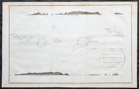
1797 Wilson Large Antique Map of the Duff Isles, Solomon Islands, South Pacific
- Title : 1799 James Wilson Antique Map of Duff or Wilson Islands, Santa Cruz Solomons Is.
- Date : 1799
- Condition: (A) Very Good Condition
- Ref: 90613
- Size: 16in x 10 1/2in (405mm x 255mm)
Description:
This copper-plate engraved original antique map of Duff or Wilson Islands located northeast of the Santa Cruz Islands in the Solomon Islands province of Temotu, in the South Pacific was engraved in by Thomas foot and was published in the 1799 edition Captain James Wilsons A missionary voyage to the Southern Pacific Ocean, performed in the years 1796, 1797, 1798, in the ship Duff commanded by Captain James Wilson.Compiled from journals of the officers and the missionaries. With a preliminary discourse on the geography and history of the South Sea Islands; and an appendix, including details never before published of the natural and civil state of Otaheite.
Captain James Wilson (1760–1814), commanded the British ship Duff, which the London Missionary Society contracted in 1797 to convey a team of missionaries (consisting of thirty men, six women, and three children) to their postings in Tahiti, Tonga, and the Marquesas Islands. During the voyage, Wilson also surveyed (or confirmed the locations of) numerous islands in the Pacific, including Vanua Balavu, Fulaga and Ogea Levu in Fiji, Mangareva in the Gambier Islands, Pukarua in the Tuamotus, and Satawal, Elato, and Lamotrek, in the Caroline Islands.
Three years after the establishment of the British mission in Tahiti, the directors of the Society appointed a committee to consider a suitable memorial for presentation to Wilson for his services in helping to establish the first mission in the South Seas.
He published an account of his voyage: A Missionary Voyage to the Southern Pacific Ocean in 1799. (Ref: M&B; Tooley)
General Definitions:
Paper thickness and quality: - Heavy and stable
Paper color : - off white
Age of map color: -
Colors used: -
General color appearance: -
Paper size: - 16in x 10 1/2in (405mm x 255mm)
Plate size: - 15in x 9 1/2in (380mm x 240mm)
Margins: - Min 1/4in (5mm)
Imperfections:
Margins: - Light soling
Plate area: - Folds as issued
Verso: - Light soling
Background:
The Duff Islands are a small island group lying to the northeast of the Santa Cruz Islands in the Solomon Islands province of Temotu. They are also sometimes known as the Wilson Islands.
The first recorded sighting by Europeans of the Duff Islands was by the Spanish expedition of Pedro Fernández de Quirós where it anchored on 8 April 1606. Its inhabitants named the islands as Taumako. They were charted by Quirós as Nuestra Señora del Socorro (Our Lady of Succour in Spanish).
The Duff Islands were named after missionary ship Duff, captained by James Wilson, which reached them in 1797.